Belousov Alexander, Belousova Marina Eruptive process, effects and deposits of the 1996 and the ancient basaltic phreatomagmatic eruptions in Karymskoye lake, Kamchatka, Russia
/ Volcaniclastic Sedimentation in Lacustrine Settings. Oxford, UK: Blackwell Publishing Ltd. 2001. P. 35-60. doi: 10.1002/9781444304251.ch3.
Churikova T., Dorendorf F., Wörner G. Sources and Fluids in the Mantle Wedge below Kamchatka, Evidence from Across-arc Geochemical Variation // Journal of Petrology. 2001. Vol. 42. № 8. P. 1567-1593. doi:10.1093/petrology/42.8.1567.
Аннотация
Major and trace element and Sr–Nd–Pb isotopic variations in mafic volcanic rocks hve been studied in a 220 km transect across the Kamchatka arc from the Eastern Volcanic Front, over the Central Kamchatka Depression to the Sredinny Ridge in the back-arc. Thirteen volcanoes and lava fields, from 110 to 400 km above the subducted slab, were sampled. This allows us to characterize spatial variations and the relative amount and composition of the slab fluid involved in magma genesis. Typical Kamchatka arc basalts, normalized for fractionation to 6% MgO, display a strong increase in large ion lithophile, light rare earth and high field strength elements from the arc front to the back-arc. Ba/Zr and Ce/Pb ratios, however, are nearly constant across the arc, which suggests a similar fluid input for Ba and Pb. La/Yb and Nb/Zr increase from the arc front to the back-arc. Rocks from the Central Kamchatka Depression range in 87Sr/86Sr from 0·70334 to 0·70366, but have almost constant Nd isotopic compositions (143Nd/144Nd 0·51307–0·51312). This correlates with the highest U/Th ratios in these rocks. Pb-isotopic ratios are mid-ocean ridge basalt (MORB)-like but decrease slightly from the volcanic front to the back-arc. The initial mantle source ranged from N-MORB-like in the volcanic front and Central Kamchatka Depression to more enriched in the back-arc. This enriched component is similar to an ocean-island basalt (OIB) source. Variations in (CaO)6·0–(Na2O)6·0 show that degree of melting decreases from the arc front to the Central Kamchatka Depression and remains constant from there to the Sredinny Ridge. Calculated fluid compositions have a similar trace element pattern across the arc, although minor differences are implied. A model is presented that quantifies the various mantle components (variably depleted N-MORB-mantle and enriched OIB-mantle) and the fluid compositions added to this mantle wedge. The amount of fluid added ranges from 0·7 to 2·1%. The degree of melting changes from ∼20% at the arc front to <10% below the back-arc region. The rocks from volcanoes of the northern part of the Central Kamchatka Depression—to the north of the transect considered in this study—are significantly different in their trace element compositions compared with the other rocks of the transect and their source appears to have been enriched by a component derived from melting of the edge of the ruptured slab.
Donnadieu Franck, Merle Olivier, Besson Jean-Claude Volcanic edifice stability during cryptodome intrusion // Bulletin of Volcanology. 2001. Т. 63. № 1. С. 61-72. doi:10.1007/s004450000122.
Аннотация
Limit equilibrium analyses were applied to the 1980 Mount St. Helens and 1956 Bezymianny failures in order to examine the influence on stability of structural deformation produced by cryptodome emplacement. Weakening structures associated with the cryptodome include outward-dipping normal faults bounding a summit graben and a flat shear zone at the base of the bulged flank generated by lateral push of the magma. Together with the head of the magmatic body itself, these structures serve directly to localize failure along a critical surface with low stability deep within the interior of the edifice. This critical surface, with the safety coefficient reduced by 25–30%, is then very sensitive to stability condition variation, in particular to the pore-pressure ratio (ru) and seismicity coefficient (n). For ru=0.3, or n=0.2, the deep surface suffers catastrophic failure, removing a large volume of the edifice flank. In the case of Mount St. Helens, failure occurred within a material with angle of friction ~40°, cohesion in the range 105–106 Pa, and probably significant water pore pressure. On 18 May 1980, detachment of slide block I occurred along a newly formed rupture surface passing through the crest of the bulge. Although sliding of block I may have been helped by the basal shear zone, significant pore pressure and a triggering earthquake were required (ru=0.3 and n=0.2). Detachment of the second block was guided by the summit normal fault, the front of the cryptodome, and the basal shear zone. This occurred along a deep critical surface, which was on the verge of failure even before the 18 May 1980 earthquake. The stability of equivalent surfaces at Bezymianny Volcano appears significantly higher. Thus, although magma had already reached the surface, weaker materials, or higher pore pressure and/or seismic conditions were probably required to reach the rupture threshold. From our analysis, we find that deep-seated sector collapses formed by removing the edifice summit cannot generally result from a single slide. Cryptodome-induced deformation does, however, provide a deep potential slip surface. As previously thought, it may assist deep-seated sector collapse because it favors multiple retrogressive slides. This leads to explosive depressurization of the magmatic and hydrothermal systems, which undermines the edifice summit and produces secondary collapses and explosive blasts.
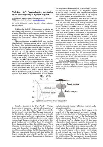
Tolstykh M.L., Naumov V.B., Ozerov A.Yu., Kononkova N.N. Composition of Magmas of the 1996 Eruption at the Karymskii Volcanic Center, Kamchatka: Evidence from Melt Inclusions // Geochemistry International. 2001. Vol. 39. № 5. P. 447-458.
Waltham Tony A guide to the volcanoes of southern Kamchatka, Russia // Proceedings of the Geologists' Association. 2001. Vol. 112. № 1. P. 67 - 78. doi: 10.1016/S0016-7878(01)80051-1.
Аннотация
The remote sub-arctic wilderness of Kamchatka contains a line of active volcanoes above the Pacific Ocean plate subduction zone. This guide is based on the itinerary of the 1999 GA excursion to sites around Petropavlovsk. Descriptions cover the Uzon caldera and its Valley of Geysers, and the volcanoes of Avacha, Karimsky, Gorely and Mutnovsky.
Алмеев Р.Р., Арискин A.A., Озеров А.Ю. ЭВМ-модель кристаллизации известково-щелочных магм (на примере вулканов Ключевской и Безымянный) / Проблемы геологии континентов и океанов: докл. рос. ученых - участников 31-го МГК (школа семинар на НИС "Академик Иоффе", июль-авг. 2000 г.). Магадан: ОГГГГН РАН. 2001. С. 167-174.
Апрелков С.Е., Попруженко С.В., Богдан П.С., Касьянюк Е.Е. Структуры фундамента и локализация вулканизма Южной Камчатки / Геодинамика и вулканизм Курило-Камчатской островодужной системы. Петропавловск-Камчатский: ИВГиГ ДВО РАН. // Геодинамика и вулканизм Курило-Камчатской островодужной системы. Петропавловск-Камчатский: ИВГиГ ДВО РАН. 2001. С. 34-44.
Аннотация
На основе анализа комплекса геолого-геофизических и петрофизических данных рассмотрены особенности развития геологической структуры и истории вулканизма Южной Камчатки. Отмечено сложное зонально-блоковое строение основания четвертичных вулканов, показаны различия в их структурной позиции по отношению региональным структурным элементам Южной Камчатки.
Базанова Л.И., Брайцева О.А., Мелекесцев И.В., Пузанков М.Ю. Потенциальная опасность от извержений Авачинского вулкана / Геодинамика и вулканизм Курило-Камчатской островодужной системы. Петропавловск-Камчатский: ИВГиГ ДВО РАН. 2001. С. 390-407.
Аннотация
Реконструирована история эруптивной активности Авачинского вулкана за последние 10 тыс.лет, определены возраст, частота и параметры прошлых извержений, характер и масштабы опасных вулканических явлений. Дана оценка вулканической опасности, связанной с деятельностью Молодого конуса вулкана, начавшего формироваться 3800 лет назад. Характер и параметры его извержений положены в основу составленной карты вулканической опасности для прилегающих территорий.