Гирина О.А., Лупян Е.А., Сорокин А.А., Романова И.М., Маневич А.Г., Мельников Д.В., Крамарева Л.С., Королев С.П., Нуждаев А.А., Уваров И.А. Информационные технологии для выявления и анализа термальной активности вулканов Камчатки и Курильских островов в 2021-2022 гг. // Информационные технологии и высокопроизводительные вычисления: материалы VII Международной науч.- практ. конф., Хабаровск, 11-13 сентября 2023 г. Хабаровск: ХФИЦ ДВО РАН. 2023. С. 52-56.
Annotation
Based on the processing of data from daily satellite monitoring carried out using the information system "Remote monitoring of the activity of volcanoes in Kamchatka and the Kuril Islands (VolSatView)", an analysis of the 2021-2022 thermal activity of Kamchatka and the Kuril Islands volcanoes is presented.
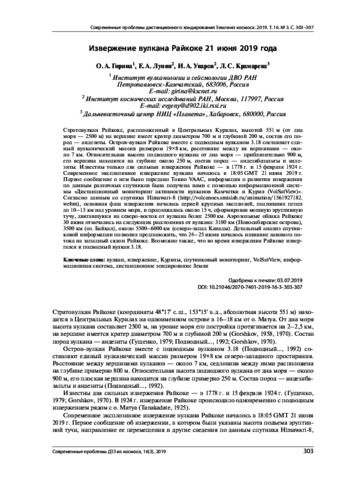
Гирина О.А., Лупян Е.А., Уваров И.А., Крамарева Л.С. Извержение вулкана Райкоке 21 июня 2019 года // Современные проблемы дистанционного зондирования Земли из космоса. 2019. Т. 16. № 3. С. 303-307. https://doi.org/10.21046/2070-7401-2019-16-3-303-307.
Annotation
Raikoke stratovolcano is located in the Central Kuril Islands, with a height of 551 m (or 2500 m from the bottom of the sea), it has a crater on its peak with a diameter of 700 m and a depth of 200 m, the composition of its rocks is andesites. The island-volcano Raikoke together with the underwater volcano 3.18 is a single volcanic massif of 19×8 km in size, the distance between their peaks is about 7 km. The relative height of the underwater volcano from the bottom of the sea is about 900 m, its top is at a depth of about 250 m, the composition of the rocks of the underwater volcano is andesibasalts and andesites. There were only two known strong eruptions of Raikoke: in 1778 and on 15 February 1924. The current explosive eruption of Raikoke volcano began at 18:05 GMT on 21 June 2019. The first message about the eruption was transmitted by Tokyo VAAC; the information about the development of the eruption based on various satellites was obtained by us using the information system “Remote monitoring of the activity of volcanoes of Kamchatka and the Kuriles (VolSatView)”. According to the Himawari-8 satellite data (http://volcanoes.smislab.ru/animation/1561927182.webm), the main phase of the eruption began with a series of large explosions that raised ash to 10–13 km above sea level, and lasted about 15 hours, forming a powerful eruptive cloud moving over 2500 km North-East from the volcano. On 30 June, the aerosol clouds from Raikoke were observed at distances from the volcano: 3100 km (Novosibirsk Islands), 3500 km (Lake Baikal), about 5500–6000 km (Northwest Canada). A detailed analysis of satellite information suggested that on 24–25 June a lava flow began to pour out on the western slope of Raikoke. It is also possible that during the eruption of Raikoke, the underwater volcano 3.18 also erupted.
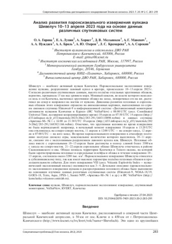
Гирина О.А., Лупян Е.А., Хорват А., Мельников Д.В., Маневич А.Г., Нуждаев А.А., Бриль А.А., Озеров А.Ю., Крамарева Л.С., Сорокин А.А. Анализ развития пароксизмального извержения вулкана Шивелуч 10–13 апреля 2023 года на основе данных различных спутниковых систем // Современные проблемы дистанционного зондирования Земли из космоса. 2023. Т. 20. № 2. С. 283-291. https://doi.org/10.21046/2070-7401-2023-20-2-283-291.
Annotation
Sheveluch volcano is the most active volcano in Kamchatka. The paroxysmal explosive eruption of the volcano that destroyed the lava dome in the volcanic crater continued on April 10–13, 2023. According to various satellite data, the height of the separate eruptive clouds probably exceeded 15 km a. s. l. A powerful cyclone, which dominated the entire Kamchatka Peninsula, pulled the eruptive cloud to the west, turned it to the south, stretched it to the north and directed it to the east from the volcano. The dynamics of the development of ash and aerosol clouds of this eruption is reflected in the animations made from a series of Himawari-9 satellite images in the VolSatView IS from 08:00 UTC (Coordinated Universal Time) on April 10 to 07:50 UTC on April 14 (http://d33.infospace.ru/jr_d33/materials/2023v20n2/283-291/1683110898.webm) and of the Arctica-M1 satellite from 16:00 to 21:30 UTC April 10 (http://d33.infospace.ru/jr_d33/materials/2023v20n2/283-291/1683821166.webm). It was noted that the eruptive column was not vertical: for example, at the initial moment of the eruption on April 10 at 13:20 UTC, it deviated to the north-northeast, on April 11 at 12:00 UTC to the northwest, and on April 12 at 07:00 UTC to the southwest. During the paroxysmal eruption, sulfur dioxide continuously entered the atmosphere, the maximum amount of which was released on April 10–11, as a result of the explosive destruction of the lava dome of the Sheveluch volcano. Ash clouds along with aerosol clouds on April 10–13 were stretched into a strip more than 3500 km long from west to northeast. On April 21–22, the Sheveluch aerosol cloud was observed in the region of the Scandinavian Peninsula. The total area of the territory of Kamchatka and the Pacific Ocean where ash and aerosol plumes and clouds were observed during the April 10–13 eruption was about 3280 thousand km2. The paroxysmal eruption of Sheveluch volcano belongs to the sub-Plinian type because it is characterized by a big height of eruptive cloud and a long event duration. For this eruption, the VEI (Volcanic Explosivity Index) is estimated to be 3–4. A detailed description of the paroxysmal explosive eruption of Sheveluch volcano and the spread of the eruptive cloud was performed based on data from various satellite systems (Himawari-9, NOAA-18/19, GOES-18, Terra, Aqua, JPSS-1, Suomi NPP, Arctica-M1 etc.) in the information system “Remote monitoring of the activity of the volcanoes of the Kamchatka and the Kuriles” (VolSatView, http://kamchatka.volcanoes.smislab.ru).
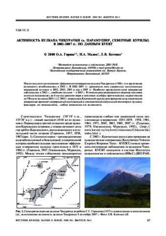
Гирина О.А., Малик Н.А., Котенко Л.В. Активность вулкана Чикурачки (о. Парамушир, Северные Курилы) в 2002-2007 гг. по данным KVERT // Вестник КРАУНЦ. Серия: Науки о Земле. 2008. Вып. 11. № 1. С. 67-73.
Annotation
После сильного эксплозивно-эффузивного извержения вулкана Чикурачки в 1986 г. его эруптивная активность возобновилась в 2002 г. В 2002-2007 гг. произошло пять умеренных эксплозивных извержений вулкана: в 2002, 2003, 2005 и два в 2007 гг. Наиболее продолжительное извержение наблюдалось в 2002 г., наиболее сильное – в 2003 г. В течение рассматриваемого периода пепловая колонна поднималась до 6 км над уровнем моря и пепловые шлейфы протягивались на расстояния до 700 км от вулкана (2003 г.). С 2002 г. сотрудники Камчатской группы реагирования на вулканические извержения проводят непрерывный спутниковый и эпизодический визуальный мониторинг вулкана, фиксируя, по возможности, любые изменения его активности.
Гирина О.А., Малик Н.А., Котенко Л.В. Действующие вулканы Северных Курил и их активность в 2004-2005 гг. // Материалы конференции, посвященной Дню вулканолога, Петропавловск-Камчатский, 30 марта - 1 апреля 2005 г. Петропавловск-Камчатский: ИВиС ДВО РАН. 2005. С. 79-87.
Гирина О.А., Мальковский С.И., Сорокин А.А. Ретроспективный анализ извержения 1964 г. вулкана Шивелуч (Камчатка) с помощью информационной системы VolSatView // Современные проблемы дистанционного зондирования Земли из космоса. Тезисы докладов. Шестнадцатая Всероссийская открытая конференция. 12-16 ноября 2018 г. М.: ИКИ РАН. 2018.
Гирина О.А., Мальковский С.И., Сорокин А.А., Лупян Е.А. Ретроспективный анализ извержения 1964 г. вулкана Шивелуч (Камчатка) с помощью информационной системы VolSatView // Информационные технологии в дистанционном зондировании Земли - RORSE 2018. Электронный сборник статей 16-й конференции (12-16 ноября 2018 г., Москва, Россия) (2019 г.). М.: ИКИ РАН. 2019. С. 34-41. https://doi.org/10.21046/rorse2018.34.
Annotation
Owing to modern development of information technologies and computer simulation systems, and datasets derived from open historical meteorological data archives, it appeared possible to perform retrospective analysis of large explosive volcanic eruptions. This work analyzes the results of simulation of the events associated with the eruptive cloud propagation during the catastrophic eruption of the November, 1964 Sheveluch volcano. The obtained additional eruptive cloud parameters enabled us to reproduce the dynamics of the explosive eruption and to validate its magmatic genesis.
Гирина О.А., Мальковский С.И., Сорокин А.А., Лупян Е.А. Ретроспективный анализ распространения эруптивной тучи во время катастрофического извержения вулкана Шивелуч в ноябре 1964 г. // Вулканизм и связанные с ним процессы. Материалы XXII Всероссийской научной конференции, посвящённой Дню вулканолога, 28-29 марта 2019 г. Петропавловск-Камчатский: ИВиС ДВО РАН. 2019. С. 55-58.
Гирина О.А., Маневич А.Г., Лупян Е.А., Уваров И.А., Романова И.М., Сорокин А.А., Королев С.П., Крамарева Л.С. Термальная активность вулканов Северной группы Камчатки в 2015-2022 гг. // Вулканизм и связанные с ним процессы. Материалы XXVII ежегодной научной конференции, посвящённой Дню вулканолога, 27-29 марта 2024 г. Петропавловск-Камчатский: ИВиС ДВО РАН. 2024. С. 52-55.
Annotation
Исходя из анализа Величины Разницы Температур термальной Аномалии и Фона (ВРТАФ) в информационной системе VolSatView определен «фон активности» вулканов Шивелуч, Ключевской и Безымянный для периода 2015-2022 гг. Совместный анализ динамики извержения каждого вулкана и изменения его термальной активности позволил установить диапазон ВРТАФ для разных фаз извержения вулкана.