Гришин С.Ю. Воронки взрывов у края лавового потока Толбачинского извержения (Камчатка, 2012-2013 гг.) // Вестник КРАУНЦ. Серия: Науки о Земле. 2015. Вып. 28. № 4. С. 72-79.
Annotation
Investigation of place of contact between the fresh lava flow from the 2012-2013 Tolbachik eruption and forest vegetation revealed an unusual phenomenon such as craters from explosions, partially destroyed old lava cover and soil-pyroclastic cover. Besides, traces of powerful scorching on the trunks of alder thickets adjacent to the craters were also found. Most likely, these craters have resulted from explosions that occurred due to the concentration of methane in the cracks and cavities in the old lava. The methan was caused by wood pyrolysis, buried by red-hot lava of 2012 eruption.
Гришин С.Ю. Поражение древесной растительности на острове Матуа (Курилы, 2007 г.) под воздействием газовой эмиссии вулкана Пик Сарычева // Вестник КРАУНЦ. Серия: Науки о Земле. 2013. Вып. 21. № 1. С. 66-76.
Annotation
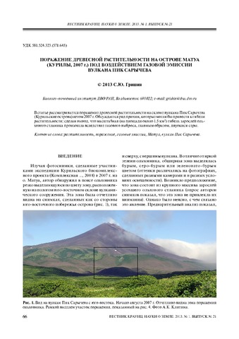
The article describes the affected woody vegetation on the slope of Sarychev Peak, the Kuriles, in 2007 and discusses some reasons that could have lead to the vegetation death. Besides, the article provided a conclusion that a large-scale destruction of alder elfin wood was caused by gas emission, chiefly by SO2.
Гришин С.Ю., Белоусов А.Б, Белоусова М.Г., Ауэр A., Koзырев И.А. Эксплозивное извержение острова-вулкана Райкоке (Курилы) в 2019 г.: пирокластические отложения и их воздействие на рельеф и экосистемы // Вулканология и сейсмология. 2021. № 6. С. 30-42.
Annotation
В июне 2019 г. на небольшом острове-вулкане Райкоке, расположенном в центральной части Курильской дуги, произошло короткое, но сильное эксплозивное извержение, кульминационная стадия которого продолжалась 3.5 ч, высота пеплового облака достигла 13 км. Анализ серии спутниковых изображений в сочетании с наземными исследованиями позволили охарактеризовать пирокластические отложения извержения и определить масштаб их воздействия на экосистемы острова. Установлено, что извержение имело фреатомагматический субплинианский–плинианский характер.
Гришин С.Ю., Гирина О.А., Верещага Е.М., Витер И.В. Мощное извержение вулкана Пик Сарычева (Курильские острова, 2009 г.) и его воздействие на растительный покров // Вестник ДВО РАН. 2010. № 3. С. 40-50.
Annotation
Very powerful eruption of Sarychev Peak volcano (Matua Isl., the Central Kuriles) in June 2009 is examined in the paper. Nature of the eruption and its catastrophic impact on the island ecosystem (using vegetation as an example) are described based on remote sensing data (photos from the space) and ground observations, carried out in summer of 2009.
Гришин С.Ю., Комачкова И.В. Температура отложений мощного пирокластического потока 2005 г. на вулкане Шивелуч (Камчатка) и начало его зарастания // Вестник КРАУНЦ. Серия: Науки о Земле. 2011. Вып. 18. № 2. С. 128-134.
Annotation
Thick deposits of pyroclastic flow from Shiveluch Volcano (February 2005) have remained high temperature for 6 years after the eruption. Despite the increased temperature of the deposits, plants began its colonization in recent years. To identify features of succession certain characteristics of unusual ecotope have been studied, including distribution of temperature background.
Гришин С.Ю., Мелекесцев И.В. Лавовые потоки (извержение 2009 г.) вулкана Пик Сарычева (Центральные Курилы) // Вестник КРАУНЦ. Серия: Науки о Земле. 2010. Вып. 15. № 1. С. 232-239.
Annotation
This paper contains a first brief description for two lava flows from the 12-15 June, 2009 catastrophic eruption produced by Sarychev Peak, Matua Island, the Central Kuriles. Previously this eruption was considered to be explosive. The flows from the eruption are about 2.4 and 2.7 km long and 100 to 150 m wide, in some places they are as wide as 350 m. The flows occupy the territory of 0.8 km2 with lava volume of 10 million km3. They travelled along sector grabens simultaneously with pyroclastic flows burning elder woods and mountain meadows and were partially overlapped by pyroclastics.
Гришин С.Ю., Перепелкина П.А., Бурдуковский М.Л., Яковлева А.Н. Начало восстановления лесной растительности после воздействия пирокластической волны вулкана Шивелуч (Камчатка) 27 февраля 2005 г. // Вестник КРАУНЦ. Серия: Науки о Земле. 2017. Вып. 36. № 4. С. 28-38.
Annotation
In the spruce forest destroyed by a powerful pyroclastic surge, willow has been reestablishing on the surge deposits. Over a decade, the willow has formed a 6–8 m high canopy. The authors have specified the following factors that contributed to such a rapid reestablishing: a favourable moisture regime of the root zone caused by the deposition of the surge, the resources of the buried soil that feed the willows, and a certain protective role of dead trees. Prospects of further succession are being discussed; the authors have concluded that over about a 50-year-long period the willow will mostly fall out; by the end of the century the spruce will have partially restored its positions, but the stand will be mixed.
Гришин С.Ю., Шляхов С.А. Растительность и почвы Толбачинского Дола (Камчатка) // Вестник КРАУНЦ. Серия: Науки о Земле. 2009. Вып. 14. № 2. С. 130-142.
Annotation
On the basis of the original materials obtained since 1978, the authors examine soil and vegetational cover within the zone of the strongest basalt eruption in Kamchatka. An intense ashfall in the summertime of 1975 caused the fall of enormous quantity of volcanites (0.7 km3). The ashfall destroyed vegetational cover over 100 km2 and damaged it over even larger territory. We consider the vegetational cover that existed prior to the eruption, the impact of the ashfall on the forest and alpine vegetation, and unclosed vegetation of the old lava flows. We calculated the area of the damaged vegetational cover and revealed the damage factors. The authors compared the damage factor of the vegetational cover caused by other ashfalls of the last century in Kurile-Kamchatkan region. Regional soils were studied for the first time.
Гузиев И.С. Щелочная оливин-базальтовая формация Западной Камчатки / Вулканизм и геохимия его продуктов. Труды Института вулканологии СО АН СССР. М.: Наука. 1967. Вып. 24. С. 126-144.