Двигало В. Н., Дрознин В. А. Аэрофототепловая съемка побочного извержения Ключевского вулкана // Вулканология и сейсмология. 1980. № 5. С. 77
Annotation
На извержении, начавшемся 5.III.1980 г., выполнен комплекс аэросъемочных работ, включавший аэрофото- и тепловую съемки района.
Двигало В.Н., Кирсанов И.Т., Селезнев Б.В. Аэрофотограмметрические наблюдения на побочном извержении Ключевского вулкана // Вулканология и сейсмология. 1981. № 1. С. 74-76.
Двигало В.Н., Мелекесцев И.В. Крупные современные обвалы на конусе вулкана Ключевской (по результатам ревизии последствий событий 1944-1945 и 1984-1985 гг.) // Вулканология и сейсмология. 2000. № 1. С. 3-17.
Annotation
Выявленные с помощью методов фотограмметрии изменения морфологии конуса вулкана Ключевской и ревизия других последствий извержений 1984-1985, 1944-1945 и 1994 гг. позволили по-новому проинтерпретировать ранг и геолого-геоморфологический эффект этих событий. Показано, что их видимый "катастрофизм" обусловлен крупными (0.006 км3-2.12.1985 г. и 0.05 км3- 1.01.1945 г.) обвалами привершинной части вулкана, а возникшие отрицательные формы - типичные шарра, в понимании А. Риттманна. Извержение вулкана Ключевской 1.01.1945 г. нельзя считать пароксизмальным, поскольку не было характерных для такого типа его извержений массового выброса юве-нильной пирокластики и резкого прекращения эруптивной активности.
Двигало В.Н., Федотов С.А., Чирков А.М. Вулкан Плоский Толбачик / Действующие вулканы Камчатки. В 2-х т. Т. 1. М.: Наука. 1991. С. 200-211.
Двигало В.Н., Чирков А.М., Федотов С.А. Новая вершинная кальдера Плоского Толбачика / Большое трещинное Толбачинское извержение. Камчатка. 1975-1976. М.: Наука. // Большое трещинное Толбачинское извержение (1975-1976 гг., Камчатка). М.: Наука. 1984. С. 75-84.
The first results of tephrachronological researches of the Sarychev Peak volcano, the Matua Island, (Central Kuriles) are represented including the reconstruction of its eruptive history in the Holocene. Based on the study of the distribution of petrogenous oxides and microelements in the tephra sampled layer-by-layer from the reference section of soil-pyroclastic cover of Matua Island, a general trend of the geochemical evolution of the volcano products during the Holocene epoch is traced, their typification was made. The horizons of the transition ashes were identified.
Дегтерев А.В., Рыбин А.В., Разжигаева Н.Г. Исторические извержения вулкана Пик Сарычева (о. Матуа, Курильские острова) // Вестник КРАУНЦ. Серия: Науки о Земле. 2011. Вып. 17. № 1. С. 102-119.
Annotation
The article provides data on historical events of the Kurile island arc’s most active Peak Sarychev Volcano, Matua Island, the Central Kuriles. During the study period the volcano was producing short terminal eruptions of explosive and explosive-effusive types discharging volcanites chiefly with pyroclastic flows and related formations.
Дегтерев А.В., Чибисова М.В., Романюк Ф.А. Эффузивно-эксплозивное извержение вулкана Алаид в 2022 г. (о. Атласова, Северные Курильские острова) // Вестник КРАУНЦ. Серия: Науки о Земле. 2023. Вып. 2. № 58. С. 17-28. 12 с. doi: 10.31431/1816-5524-2023-2-58-17-28.
Annotation
Data are presented on a moderate effusive-explosive eruption of the summit crater of Alaid volcano (Atlasov Island, Northern Kuril Islands) observed from September 10 to December 1, 2022. Based on satellite and visual data, it was found that as a result of Strombolian-Volcan activity two lava flows, 2.6 and 1 km long, were poured out on the southern slope of the volcano, and at least 16 emissions occurred to a height of 2.5 to 6 km a.s.l. The ash plumes spread out mainly in the southeast and east-southeast directions, their maximum length reaching 300–500 km. The eruption posed a danger to local airlines. The lava outpouring provoked the formation of lahars that descended the southern slope of the volcano and reached the island coast. The alluvial fan formed from mudflow masses partially deposited beyound the coastline, causing an increase in the island land.
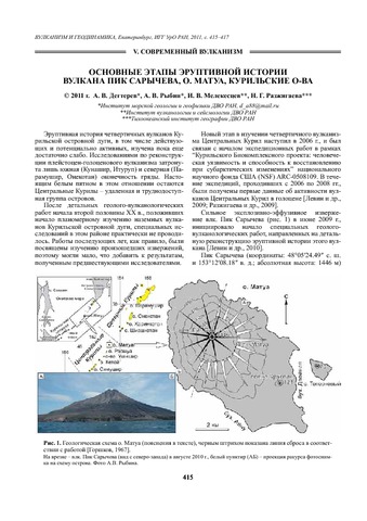
Дегтярев А.В., Рыбин А.В., Мелекесцев И.В., Разжигаева Н.Г. Основные этапы эруптивной истории вулкана Пик Сарычева, о. Матуа, Курильские острова // Вулканизм и геодинамика. Материалы V Всероссийского симпозиума по вулканологии и палеовулканологии, г. Екатеринбург, 21-25 ноября 2011 г. Екатеринбург: ИГГ УрО РАН. 2011. С. 415-417.
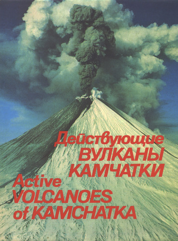
Действующие вулканы Камчатки. В 2-х т. Т. 1 / Отв. ред. Федотов С.А., Масуренков Ю.П. М.: Наука. 1991. 302 с.
Annotation
The book provides a systematic description of active volcanoes of Kamchatka — one of the most active volcanic regions of the world. Distribution, shape and activity of the volcanoes, their position in complex and long-lived volcanic centres, as well as their geologic structure and composition are presented.
The book is illustrated with colour maps, schemes, and sketches. Over 300 colour photographs show volcanic landscapes, diverse volcanic forms (cones, craters, lava flows, calderas, etc.) and various manifestations of post-volcanic activity (hydrotherms, famous Kamchatka geysers).
Concise, lavishly illustrated with colourful and high-quality photographs, the book makes an interesting and useful reading not only for specialists (volcanologists, geologists, geochemists, geophysicists, geographes, etc.) but for a bioad readership as well. The publication is unique and unparalleled in scientific literature. The text is presented in Russian and in English.
This monography is written by scientists from the Institute of volcanology, Far East Division, the Academy of Science of the USSR.