Koulakov Ivan, Jaxybulatov Kayrly, Shapiro Nikolay M., Abkadyrov Ilyas, Deev Evgeny, Jakovlev Andrey, Kuznetsov Pavel, Gordeev Evgeny, Chebrov Viktor Asymmetric caldera-related structures in the area of the Avacha group of volcanoes in Kamchatka as revealed by ambient noise tomography and deep seismic sounding // Journal of Volcanology and Geothermal Research. 2014. Vol. 285. P. 36 - 46. doi: 10.1016/j.jvolgeores.2014.08.012.
Аннотация
Avacha group includes two active and potentially dangerous volcanoes, Avachinsky and Koryaksky, located close to Petropavlovsk-Kamchatsky, the main city of Kamchatka. We present the results of two independent seismic studies of shallow crustal structures beneath the Avacha group based on passive and active source observations. The first study is based on the analysis of continuous recording by 11 seismic stations installed over the Avacha group in 2012 and 7 permanent stations in the same region. We present a series of 2D Rayleigh-wave group velocity maps based on correlation of ambient noise, that were then converted into 3D distribution of shear wave velocity. The second work was based on the reprocessing of an active source deep seismic sounding profile across the Avachinsky volcano that was shot in 1982–1984. We made the analysis of travel times of refracted waves using a 2D tomography inversion. The resulting seismic models appear to be consistent with each other and show clear low-velocity zone to the SW of the Avachinsky volcano and high velocity structures to NE. These observations also agree with the existing gravity and magnetotelluric measurements. Based on the obtained seismic models we identify two large buried calderas and large lava flows that are thought to be related to a series of large eruption episodes of Avachinsky occurred within the last 30,000 years.
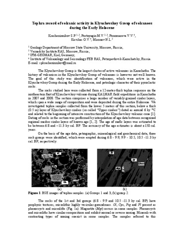
Krasheninnikov Stepan, Portnyagin Maxim, Ponomareva V.V., Bergal-Kuvikas Olga, Mironov Nikita Periodic volcanic activity of Klyuchevskoy and Ushkovsky volcanoes during the early Holocene inferred from tephra study 2009.
Krippner J., Belousov A., Belousova M., Ramsey M. Parametric analysis of lava dome-collapse events and pyroclastic deposits at Shiveluch volcano, Kamchatka, using visible and infrared satellite data // Journal of Volcanology and Geothermal Research. 2018. № 354. P. 115-129.
Kugaenko Yulia, Titkov Nikolay, Saltykov Vadim Constraints on unrest in the Tolbachik volcanic zone in Kamchatka prior the 2012–13 flank fissure eruption of Plosky Tolbachik volcano from local seismicity and GPS data // Journal of Volcanology and Geothermal Research. 2015. Vol. 307. P. 38 - 46. doi: 10.1016/j.jvolgeores.2015.05.020.
Аннотация
Abstract A new fissure eruption began on 27 November 2012 on the southern slope of Plosky Tolbachik volcano, which is located in central Kamchatka, Russia, and is part of the Klyuchevskoy volcano group. We analyzed the displacement of the earth surface and the seismicity during several months before the eruption onset. According to seismic and GPS data the eruption was preceded by about 4–5 months (July–November 2012) of synchronous crustal deformation and seismicity. The seismic anomaly comprises low energy level seismicity (mainly M = 1.2–2.3) under Plosky Tolbachik volcano at a depth of less than 5 km. In the 2–3 weeks immediately preceding the eruption the rate of seismicity and the amount of radiated seismic energy exceeded the long-term average values (2000–2011) by more than 40 times. The deformation anomaly was recorded by displacement of the GPS points at distances from 20 to 60 km to the north of Tolbachik. The principal axis of the compressive strain was approximately directed towards the Tolbachik eruption site. The permanent GPS network detected radial compression and tangential stretching. The compressive strain reached about 10− 7 prior to eruption onset. The comparable duration of seismic and deformation anomalies (~ 4–5 months before the eruption) is consistent with a common origin, connected to magma rising from depth, and is interpreted as indicating that they were medium-term precursors to the eruption. Data recorded during this unrest episode of the Tolbachik volcanic zone will contribute to understanding of the reawakening of volcanic activity in this region and others worldwide with similar characteristics.
Kugaenko Yulia, Volynets Anna O. Magmatic plumbing systems of the monogenetic volcanic fields: A case study of Tolbachinsky Dol, Kamchatka // Journal of Volcanology and Geothermal Research. 2018. doi:10.1016/j.jvolgeores.2018.03.015.
Аннотация
Clusters of small-volume volcanoes that individually may be defined as monogenetic, but have interlinked and
interconnected plumbing systems, are used to be categorized as monogenetic volcanic fields (MVF).We argue
that such volcanic clusters should be distinguished as separate type of volcanism, intermediate between monogenetic and polygenetic. The magma plumbing system structure of the MVF (its complexity and polymagmatic
character) is the key argument for the potential separation of themin a classification. To avoid confusion caused by geneticmeaning of the used words we suggest using a term “areal volcanism” or “areal volcanic fields” (AVF instead of MVF) as defining this special type of volcanic activity. Herewe provide a reviewof themain characteristic features of one of the largest Holocene AVF, which is active now – the Tolbachik field of cinder cones in the southern part of Klyuchevskaya volcano group (Kamchatka), known in the literature as Tolbachinsky Dol. This paper is focused on the research of magma plumbing system. We consider structural,morphological, geological, geochemical and petrological data on the erupted basalts and their genesis. Specially planned seismic experiments made in 2010–2015 (seismic tomography and microseismic sounding) allowedmodeling of the principal elements of the magma plumbing system of Tolbachik AVF. Analysis of the investigations made in this area shows that Tolbachik AVF has a complex, dynamic, variable magmatic feeding system, which can be visualized as a superposition of subvertical and sublateral magma conduits. The contrast composition of the erupted rocks is caused by their different, although genetically connected, magma sources and mixing processes. One of the long-lived eruptive centers of Tolbachik AVF is Plosky Tolbachik stratovolcano, which lost its independent activity and was captured by Tolbachik AVF in Holocene. The AVF formed rejuvenated volcanism using the feeding system of the stratovolcano like an “old anthill”. The magma plumbing system characteristics of Tolbachinsky Dol strongly support the idea of separation of AVF from monogenetic volcanism type in the classification.
Kuno H. Petrology of Alaid volcano, north Kurile // Japanese journal of geology and geography. 1935. Vol. 12. P. 153-162.
Kuznetsova E., Muravyev Y.D., Motenko R. The physical and chemical properties of volcanic ashes of different ages (Kamchatka) // Вулканизм и геодинамика. Мат-лы IY ВС по Вулканологии и палеовулканологии. сентябрь 2011 г., Петропавловск-Камчатский. 2011.
Аннотация
Большая часть Камчатки покрыта почвенно-пирокластическим чехлом, который представляет собой непрерывно накапливающийся "слоёный пирог", состоящий из горизонтов тефры и погребенных почв. Пеплы крупнейших извержений образуют чёткие маркирующие прослои во вмещающих отложениях, которые прослеживаются на огромных территориях. Толща между маркирующими прослоями пеплов имеет также пирокластическую природу и включает как продукты менее мощных или дальних извержений, так и вторично переотложенные пеплы [2]. В данной работе представлены результаты исследования физико-химических свойств вулканических пеплов, представленных как пеплами-маркерами, так и неопознанной тефрой.
В работе использовались следующие экспериментальные методы исследования:
- гранулометрический состав определялся пипеточным методом (ГОСТ…).
- теплопроводные характеристики вулканических пеплов определяли методом регулярного режима I рода [7].
- фазовый состав влаги и температура начала замерзания определялись криоскопическим и контактным методами [7].
- минеральный анализ определен на ИК-спектрометре ФСМ-1201 (Россия) в интервале 400-4000 cм-1 при комнатной температуре. Спектральное разрешение составляло 2,0 cм-1, абсолютная калибровочная ошибка волнового числа - не больше ±0,1 cм-1 [6]. Состав стекол этих пеплов был проанализирован на микрозонде "Jeol JSM-6480LV", энергодисперсионным спектрометром "INCA-Energy 350" (окно ATW-2) в Лаборатории локальных методов исследования вещества МГУ.
Были исследованы образцы вулканического пепла, отобранные в районе Ключевской группы вулканов и в долине р. Камчатка, в диапазоне высот 129-1650 м. Почти все пеплы относятся к голоценовым, за исключением образца, отобранного из отложений озерных диатомовых глин яра Половинка в долине р. Камчатки, возраст которых относится ко второй половине раннего плейстоцена (Q21). Образец представляет собой белый рыхлый витрокластический пепел кислого состава.
Согласно ГОСТ 25100-95 по гранулометрическому составу вулканические пеплы относятся к пескам пылеватым. По содержанию SiO2 вулканическое стекло исследуемых пеплов относится к трем типам: риолитовый, андезитовый и базальтовый. Согласно данным ИК-спектроскопии в камчатских пеплах с андезитовым и базальтовым стеклом был найден аллофан, с риолитовым стеклом - опал (аллофан - аморфный слоистый алюмосиликат, опал - минерал подкласса гидроксидов, не является глинистым минералом).
Получены следующие результаты исследования физ.-хим. свойств рассматриваемых пеплов.
Фазовый состав влаги. Впервые в наших исследованиях был получен фазовый состав влаги (т.е. содержание льда, незамерзшей воды и пара) в мерзлых вулканических пеплах Камчатки (ссылки на наши работы). Наиболее важная характеристика фазового состава влаги в мёрзлой породе - зависимость содержания незамерзшей воды Ww от температуры t. Экспериментально установлены зависимости содержания незамерзшей воды от температуры для мёрзлых вулканических пеплов в диапазоне температур от 0 до -15 оС, содержание Ww при температуре ниже -3 оС изменяется незначительно. Установлено, что, например, при температуре определения теплофизических характеристик -10оС в исследуемых образцах содержание незамерзшей воды изменяется от 0 до 11%. Это связано с преобразованием вулканического стекла и появлением глинистых минералов (аллофанов). Последние характеризуются большой удельной поверхностью, что и определяет появление разного количества незамерзшей воды.
Теплопроводные свойства. Получены экспериментальные данные по изучению теплопроводности вулканических пеплов для талого и мерзлого состояния в широком диапазоне влажности и плотности (ссылки на наши работы). При изменении влажности от 0 до 78% и плотности скелета ?d от 0,7 до 1,7 г/см3 коэффициент теплопроводности ? закономерно увеличивается от 0,13 до 1,0 Вт/(м·К) в талом и от 0,14 до 1,27 Вт/(м·К) в мерзлом состоянии. При этом не смотря на то, что вулканические пеплы по гранулометрическому составу относятся к пескам пылеватым, они очень сильно отличаются от последних. Так, сравнение данных по теплопроводности для вулканогенно-обломочных и осадочных дисперсных пород показало, что вулканические дисперсные породы имеют очень низкую теплопроводность как в талом, так и в мерзлом состоянии, что объясняется многими причинами, например, разностью теплопроводностей скелета пород (теплопроводности кварца и вулканического стекла отличаются в 3-4 раза), так и формой самих частиц.
Засоленность. Анализ засоленности пеплов показал, что по ГОСТ 25100-95 все исследованные пеплы, за исключением образца, отобранного из яра Половинка, относятся к незасоленным, суммарное содержание легкорастворимых солей в них около 0,02-0,03%; пепел из яра относится к сильно засоленным. По результатам химического анализа водной вытяжки этого пепла сумма солей составляет 1,815% от массы вещества, а по химическому составу представлена преимущественно сульфатами (содержание SO42- составляет 1,242% от массы вещества). Также отмечено очень низкое pH=3,4.
Kyle Philip R., Ponomareva Vera V., Rourke Schluep Rachelle Geochemical characterization of marker tephra layers from major Holocene eruptions, Kamchatka Peninsula, Russia // International Geology Review. 2011. Vol. 53. № 9. P. 1059-1097. doi:10.1080/00206810903442162.
Аннотация
Kamchatka Peninsula is one of the most active volcanic regions in the world. Many Holocene explosive eruptions have resulted in widespread dispersal of tephra-fall
deposits. The largest layers have been mapped and dated by the 14C method. The tephra provide valuable stratigraphic markers that constrain the age of many geological
events (e.g. volcanic eruptions, palaeotsunamis, faulting, and so on). This is the first systematic attempt to use electron microprobe (EMP) analyses of glass to characterize
individual tephra deposits in Kamchatka. Eighty-nine glass samples erupted from 11 volcanoes, representing 27 well-identified Holocene key-marker tephra layers, were analysed. The glass is rhyolitic in 21 tephra, dacitic in two, and multimodal in three.
Two tephra are mixed with glass compositions ranging from andesite/dacite to rhyolite. Tephra from the 11 eruptive centres are distinguished by their glass K2O,
CaO, and FeO contents. In some cases, individual tephra from volcanoes with multiple eruptions cannot be differentiated. Trace element compositions of 64 representative
bulk tephra samples erupted from 10 volcanoes were analysed by instrumental neutron activation analysis (INAA) as a pilot study to further refine the geochemical haracteristics; tephra from these volcanoes can be characterized using Cr and Th contents and La/Yb ratios.
Unidentified tephra collected at the islands of Karaginsky (3), Bering (11), and Attu (5) as well as Uka Bay (1) were correlated to known eruptions. Glass compositions and
trace element data from bulk tephra samples show that the Karaginsky Island and Uka Bay tephra were all erupted from the Shiveluch volcano. The 11 Bering Island tephra
are correlated to Kamchatka eruptions. Five tephra from Attu Island in the Aleutians are tentatively correlated with eruptions from the Avachinsky and Shiveluch volcanoes.