Melekestsev I.V., Dvigalo V.N., Kirianov V.Yu., Kurbatov A.V., Nesmachnyi I.A. Ebeko volcano, Kuril Islands: eruptive history and potential volcanic hazards. Part I // Volcanology and Seismology. 1994. Vol. 15. № 3. P. 339-354.
Annotation
The eruptive history of Ebeko Volcano is described since its origin about 2400 years ago until the beginning of the 17th century. Six stages of increased activity each lasting 200-300 years were separated by repose periods of the same duration. The eruption of juvenile material (lava and pyroclastics) took place at the first stage only (420-200 B.C.). All eruptions that followed were phreatic events of varying vigor. It is shown that, except for the first eruptive stage, the main volcanic hazard for the Ebeko area and the town of Severo-Kurilsk near by comes from large lahars and tephra fallout. -from Journal summary
Melekestsev I.V., Dvigalo V.N., Kirianov V.Yu., Kurbatov A.V., Nesmachnyi I.A. Ebeko volcano, Kuril Islands: eruptive history and potential volcanic hazards. Part II // Volcanology and Seismology. 1994. Vol. 15. № 4. P. 411-430.
Annotation
По историческим сведениям, дополненным тефрохронологическими исследованиями и материалами аэрофотосъемок I960, 1987, 1988, 1990 гг. района в. Эбеко, детально восстановлены последствия его извержений XVII-XX вв. Показано, что все извержения были фреатическими и условно фреатомагматическими с источником теплового питания в виде сильно нагретого дайково-силлового комплекса объемом более 1 км . приуроченного к зоне растяжения ССВ (аз. 25°) простирания, вдоль которого расположены вулканы хр. Вернадского на о-в Парамушир. Предполагается, что в будущем главная опасность для г. Северо-Курильска и прилежащих участков связана с прохождением большеобъемных лахаров по рекам Кузьминка и Матросская, начинающихся на в. Эбеко, в меньшей степени - с пеплопадами этого и других вулканов Северных Курил и Южной Камчатки. Доказывается, что серьезная угроза городу может возникнуть при будущем извержении в. Эбеко типа его извержения 1934-1935 гг. Рекомендованы меры для защиты города.
Melekestsev I.V., Kartasheva E.V., Kirsanova T.P., Kuzmina A.A. Water Contaminated Fresh Tephra as a Natural Hazard Factor: the 2008-2009 Eruption of Koryakskii Volcano, Kamchatka // Journal of Volcanology and Seismology. 2011. Vol. 5. № 1. P. 17-30. doi: 10.1134/S0742046311010064.
Annotation
Abstract-This study is the first to show, using data from the eruption of Koryakskii Volcano, Kamchatka that began in December 2008 and continued through 2009 that the water in permanent and temporary streams that start on the slopes of the volcanic cone and in temporary lakes when contaminated with fresh tephra is a specific hazard factor related to long-continued hydrothemial-phreatic eruptions on that volcano. This water is characterized by increased acidity (pH 4.1-4.35) and large amounts (up to 50-100 cm /liter) of solid suspension and is unfit for drinking and irrigation. When combined with tephra, it probably produced mass destruction of a number of animals who lived on the slopes and at the base of the volcano. The water contaminated with tephra is an important component of the atmospheric mud tlows occurring on Koryakskii Volcano; for several future years it will be a potential source for enhancing the acidity of ground water in the volcanic edifice.
Melekestsev I.V., Kirianov V.Yu. When will Avacha Volcano in Kamchatka erupt? // Volcanology and Seismology. 1988. Vol. 6. № 6. P. 943-952.
Melekestsev I.V., Sulerzhitskiy L.D., Bazanova L.I., Braitseva O.A., Florenskaya N.I. Holocene catastrophic lahars at Avacha and Koryakskiy volcanoes in Kamchatka // Volcanology and Seismology. 1996. Vol. 17. № 4-5. P. 561-570.
Annotation
Remnants of five catastrophic lahars have been discovered, described, and dated by the carbon-14 method. They occurred during eruptions of Avacha (violent explosions with voluminous juvenile pyroclastics) and Koryakskiy (large fissure lava flows): 3500 to 3200 14C years ago or 1900-1500 years B.C. These lahars were much higher in vigor, hazard, and effect on the environment than the lahars generated by the historic eruptions of these volcanoes. -from Journal summary
Melekestsev Ivan V., Ponomareva Vera V., Volynets Oleg N. Kizimen volcano, Kamchatka — A future Mount St. Helens? // Journal of Volcanology and Geothermal Research. 1995. Vol. 65. № 3-4. P. 205-226.
Annotation
Melnik O., Lyakhovsky V., Shapiro Nikolay M., Galina N., Bergal-Kuvikas Olga Deep long period volcanic earthquakes generated by degassing of volatile-rich basaltic magmas // Nature Communications. 2020. Vol. 11. № 3918. doi: 10.1038/s41467-020-17759-4.
Annotation
Deep long-period (DLP) earthquakes observed beneath active volcanoes are sometimes considered as precursors to eruptions. Their origin remains, however, unclear. Here, we present a possible DLP generating mechanism related to the rapid growth of gas bubbles in response to the slow decompression of over-saturated magma. For certain values of the gas and bubble content, the elastic deformation of surrounding rocks forced by the expanding bubbly magma can be fast enough to generate seismic waves. We show that amplitudes and frequencies of DLP earthquakes observed beneath the Klyuchevskoy volcano (Kamchatka, Russia) can be predicted by our model when considering pressure changes of ~107 Pa in a volume of ~103–104 m3 and realistic magma compositions. Our results show importance of the deep degassing in the generation of volcanic seismicity and suggest that the DLP swarms beneath active volcanoes might be related to the pulses of volatile-rich basaltic magmas rising from the mantle.
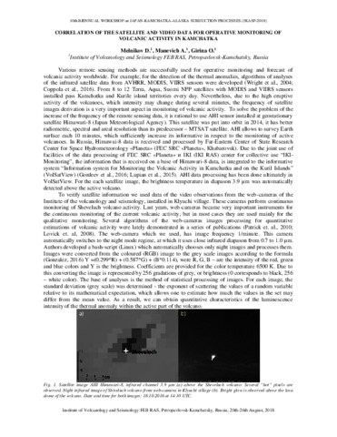
Melnikov D.V., Manevich A.G., Girina O.A. Correlation of the satellite and video data for operative monitoring of volcanic activity in Kamchatka // JKASP-2018. Petropavlovsk-Kamchatsky: IVS FEB RAS. 2018.
Melnikov D.V., Ushakov S.V., Galle B. Estimation of the sulfur dioxide emission by Kamchatka volcanoes using differential optical absorption spectroscopy // 8-th Biennial Workshop on Japan-Kamchatka-Alaska Subduction Processes, JKASP 2014. 22-26 September, 2014, Sapporo, Japan. 2014.
Annotation
During the 2012-2013 we have measured SO2 on Kamchatka volcanoes (Gorely, Mutnovsky, Kizimen, Tolbachik, Karymsky, Avachinsky) using DOAS (differential optical absorption spectroscopy). Mobile-DOAS, on a base of USB2000+, has been used as an instrument. The goal of this work was to estimate SO2 emission by Kamchatka volcanoes with the different types of activity. Mutnovsky and Avachinsky during the measurements period passively degassed with SO2 emission ~ 480 t/d and 210 t/d, respectively. Gorely volcano was very active, with intensive vapor-gas activity with gas discharge rate 800-1200 t/d. During the measurements at Karymsky volcano there were relatively weak explosive events (ash plum rose up to 0.5 km above the crater) with 5-10 minutes periodicity. For this time, SO2 discharge rate was ~350-400 t/d. Due to the remoteness and difficulties for accessibility of Kizimen volcano, the measurements were done only once – on October 15th, 2012. 5 traverses have been done above the gas plume. SO2 emission was ~ 700 t/d. On Tolbachik fissure eruption we have measured SO2 emission repeatedly from January until August 2013. The intensive effusion of the lava flows (basaltic andesite by composition) and frequent explosions in the crater of the cinder cone were characteristic features of this eruption. The measured gas emission was from ~1500-2200 t/d in January until 600-800 t/d in August 2013. All measurements were made not permanently, but to the extent possible. Therefore, it is difficult to make detailed conclusions on the SO2 emission on these volcanoes. Nevertheless, this research may become a starting point for the development of the system of the constant monitoring of volcanic gases emission by the active volcanoes of Kamchatka.
Estimation of the sulfur dioxide emission by Kamchatka volcanoes using differential optical absorption spectroscopy.
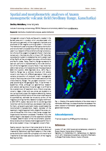
Melnikov D.V., Volynets Anna Spatial and morphometric analyses of Anaun monogenetic volcanic field (Sredinny Range, Kamchatka) // 7th International Maar Conference, Olot, Catalonia, Spain. 2018. P. 61
Annotation
Monogenetic volcanic fields are frequently located in the faulted area and in clusters which are associated with the particular geometry of the magmatic chambers and structures of the magma plumbing system in the crust. The method of cluster analyses of the spatial distribution and morphometric characteristics of the cinder cones was used in our research of the conditions of origin and evolution of one of the largest monogenetic fields in Kamchat-ka back-arc-the Anaunsky Dol, or Anaun MVF. Kamchat-ka subduction system is located at the northwestern part of the Pacific at the convergent boundary of the Okhotsk and Pacific plates. Today, Sredinny Range represents its back-arc part and is characterized by the wide distribution of the monogenetic volcanic fields: it has more than 1000 cinder cones, which deposits cover the area of about 8500 km2 (Laverov, 2005; Ogorodov et al., 1972) (Fig. 1). Sredinny Range has a complex structure with several volcanic provinces with different geological history and variable composition of products. Anaun monogenetic volcanic field occupies one of the lowest sections of the whole Sredinny Range. The youngest volcanism in this area (according to the geological map, it was formed in Quaternary times, although our geochemical research and isotopic dating shows its earlier age) is confined to the lowered block of basement rocks. Shield volcanoes, volcanic ridges, cinder and lava cones are located on a low-laying volcanic dale. We made an attempt to make a spatial analysis of distribution of the volcanic edifices and to quantitatively estimate the structural control of the magma plumbing channels. Based on a digital relief model (DEM SRTM, spatial resolution 30 m) we distinguished more than 100 morphometrically expressed cinder cones. For them, using semi-automatic mode, we estimated the morphometric characteristics: height, diameter of the basement, height/basement ratio, angle of the slope, volume of the edifice. With time, cinder cones change their shape due to the erosion processes. Therefore, finally the edifice height is decreased while the basement diameter increased. Determination of the morphometric parameters allowed us to compose a relative age scale for the cinder cones located in Anaun monogenetic volcanic field. Spatial analysis has shown that cones tend to form series of clusters, which are associated with the systems of lineaments. Statistically significant patterns in the cinder cones distribution were then compared with the strike of lineaments to estimate possible location of the magma feeding channels.