Рашидов В.А., Блох Ю.И., Бондаренко В.И., Долгаль А.С., Новикова П.Н., Трусов А.А. Применение современных геофизических технологий для узучения подводного вулкана Обручева в Курильской островной дуге // Физика геосфер: Девятый Всероссийский симпозиум, г. Владивосток 21-24 сентября 2015 г. Владивосток: Дальнаука. 2015. С. 393-397.
Рашидов В.А., Пилипенко О.В., Петрова В.В. Петромагнитные и микрозондовые исследования пород подводной вулканической группы Софу (Идзу-Бонинская островная дуга, Тихий океан) // Вулканология и сейсмология. 2015. № 3. С. 36-51. doi: 10.7868/S0203030615030049.
Annotation
A multidisciplinary study of samples that were dredged during cruises of the R/V Vulkanolog was continued in order to interpret results from a survey of the anomalous magnetic field on the Pacific seafloor. We acquired data on the main ferromagnetic carrier and the nature of magnetization. The naturally occurring magnetic parameters and petromagnetic properties of the rocks that make up the edifices of the Sofu underwater volcanic cluster at the Izu-Bonin island arc have been studied. We provide the results of thermomagnetic, petrologic, and microprobe studies of the dredged samples. It is shown that the main magnetic mineral carriers of natural remanent magnetization are unaltered titanomagnetite and oxidized titanomagnetite. The differentiation of rocks over values of natural remanent magnetization was due to different crystallization conditions for titanomagnetite, while that over magnetic susceptibility was controlled by the magnetic grain size. The structural, mineralogic, and petrographic features of the samples show that they were taken from rocks that were discharged during different phases of eruptions.
Романова И.М., Гирина О.А. Информация KVERT в сети Интернет // Вулканизм и связанные с ним процессы. Материалы XVIII региональной конференции, посвященной Дню вулканолога, 30 марта - 1 апреля 2015 г. Петропавловск-Камчатский: ИВиС ДВО РАН. 2015. С. 106-109.
Романова И.М., Гирина О.А. Информация KVERT о мониторинге вулканов Камчатки и Северных Курил в Геопортале ИВиС ДВО РАН // Геодинамические процессы и природные катастрофы. Опыт Нефтегорска: Всероссийская научная конференция с международным участием, Южно-Сахалинск, 26 - 30 мая 2015 г.: сборник материалов. В 2-х томах. Владивосток: Дальнаука. 2015. Т. 2. С. 261-265.
Романова И.М., Зеленин Е.А., Михайлюкова П.Г., Пономарева В.В. Геопортал Института вулканологии и сейсмологии ДВО РАН и геосервис «Голоценовый вулканизм Камчатки» // Геодезия и картография. 2015. № 8. С. 17-23. doi: 10.22389/0016-7126-2015-902-8-17-23.
Annotation
Development of spatial data infrastructure (SDI) is one of the modern trends of geoinformation technologies. SDI of the Institute of Volcanology and Seismology (IVS) FEB RAS has been developing since 2008. Metadata management system, storage and management of spatial data system and geoportal are the main elements of the SDI. Metadata management system provides powerful tools for creation, editing, browsing of metadata, efficient instruments for searching for data and services. The geoportal is a single point of access to metadata catalogue, collections of volcanological and seismological data, and geoservices. One of the collections is available in the Volcanoes of Kurile-Kamchatka Island Arc (VOKKIA) information web system, which integrates available volcanological data related to the volcanoes in Kamchatka, the Kurile Islands and adjacent seas. Today the VOKKIA system includes the sections: Volcanoes, Eruptions, Rocks, Monitoring, Images, Geoservices, Bibliography. Kamchatka Holocene Volcanism geoservice of the VOKKIA system shows the centers of both historic and prehistoric volcanic eruptions, age and composition of deposits etc. This paper gives a detailed description of development and core capabilities of the geoservice. Based on the international OGC standards, the geoservices allow the wider range of users to access the spatial data in contrast with the desktop GIS. Spatial metadata, data and geoservices published on the IVS FEB RAS Geoportal can be easily found through the Internet and are available for the international scientific society contributing into increased rate of data exchange between researchers.
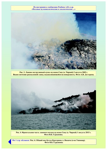
Рыбин А.В., Богомолов Л.М., Дегтерев А.В., Чибисова М.В., Копанина А.В., Власова И.И., Гурьянов В.Б., Коротеев И.Г., Давыдова М.Ю., Климанцов И.М. Полевые вулканологические и экологические исследования на Курильских островах в 2015 г. // Вестник КРАУНЦ. Серия: Науки о Земле. 2015. Вып. 28. № 4. С. 94-99.
Савельева О.Л., Савельев Д.П., Карташова Е.В. Известняки Вахильского поднятия (Восточная Камчатка): литологическая и геохимическая характеристика // Вестник КРАУНЦ. Серия: Науки о Земле. 2015. Вып. 26. № 2. С. 37-50.
Annotation
The authors studied siliceous limestones from the Vetlovsky complex of the Vakhil rise (Eastern Kamchatka). The paper provides their lithological and geochemical characteristic. The new limestones were compared with the previously studied limestones from the Albian-Cenomanian Smagin association of the Kamchatsky Mys peninsula, as well as with Cretaceous carbonates from the Pacific underwater rises. Limestones from the Vetlovsky complex deposited in the pelagic environments at low sedimentation rates, and under oxidizing conditions. Terrigenous input in deposits was insignificant. According to the geochemical data, some layers of limestones contain pyroclastics of various composition, which indicate a deposition in the area of island arc volcanism effect. The sedimentation occurred on the oceanic intraplate volcanic rise or on the internal rise of backarc basin. The major part of siliceous-carbonate oozes were forming between depths of 1-1.5km.
Соловьев А.В., Лучицкая М.В., Селянгин О.Б., Хоуриган Дж.К. Позднемеловой гранитоидный магматизм Срединного хребта Камчатки: геохронология и особенности состава // Стратиграфия. Геологическая корреляция. 2015. Т. 23. № 1. С. 60-82. doi:10.7868/S0869592X15010081.
Annotation
Представлены новые результаты детального геолого-структурного, геохронологического, петрографического и петрогеохимического изучения позднемеловых гранитоидов южной части Срединного хребта. U-Pb SIMS и LA-ICPMS датирование цирконов этих гранитоидов свидетельствует о том, что на юге Срединного хребта Камчатки в кампане (от 83.1 ± 2.0 до 76.2 ± 1.5 млн лет назад) широко проявился гранитоидный магматизм. Кампанские гранитоиды маркируют начало становления “новообразованной” континентальной коры Камчатки. Особенности состава позднемеловых гранитоидов указывают на их сходство с высокоглиноземистыми гранитами I-типа. Полученные данные позволяют выделить кампанский этап магматической активности на юге Камчатки.
Сорокин А.А., Королев С.П., Верхотуров А.Л., Шестаков Н.В., Лупян Е.А. , Гирина О.А. Информационная система для исследования опасных природных явлений на Дальнем Востоке России по данным спутниковых и наземных инструментальных наблюдений // Тринадцатая Всероссийская открытая конференция "Современные проблемы дистанционного зондирования Земли из космоса". Материалы . Москва: ИКИ РАН. 2015.
Сорокин А.А., Королев С.П., Урманов И.П., Верхотуров А.Л., Шестаков Н.В., Гирина О.А. Информационная система для работы c данными инструментальных наблюдений с целью проведения исследований и мониторинга опасных природных явлений на Дальнем Востоке России // Геодинамические процессы и природные катастрофы. Опыт Нефтегорска: Всероссийская научная конференция с международным участием, Южно-Сахалинск, 26 - 30 мая 2015 г.: сборник материалов. В 2-х томах. Владивосток: Дальнаука. 2015. Т. 2. С. 443-447.