Хренов А.П. Модель формирования стратовулканов: роль субвулканических тел в их строении // Вулканизм и геодинамика. Материалы Всесоюзного симпозиума, г. Улан-Удэ. 2006. Т. 3. С. 608-612.
Хренов А.П. Исследование вулканов методами дистанционного спутникового зондирования // Земля и Вселенная. 2011. Вып. 5. С. 12-22.
Хренов А.П. Исследование активных вулканов методами дистанционного зондирования // Современные проблемы дистанционного зондирования Земли из космоса. 2011. Т. 8. № 2. С. 166-178.
Бондаренко В.И., Рашидов В.А. Вулканический массив Черных Братьев (Курильские острова) // Вулканология и сейсмология. 2003. № 3. С. 35-51.
Annotation
The geological and geophysical research carried out during the five cruises of R/V/ Vulkanolog in the 1980s and early 1990s provided new evidence of the structure and evolution of the Chernye Bratya volcanic massif. Five phases have been identified in its evolution. The first phase which began in the Early - Middle Pleistocene, or possibly Neogene, involvel the generation of a major shield-shaped, mostly laval, volcanic massif with dimensions 30 km by 35 km. The secondphase seems to have been a catastrophic explosive eruption producing the older caldera (Gorshkov Outer Caldera) of dimensions 15 km by 20 km. It is not younger than the mid-Late Pleistocene. A large volcanic structure formed during the third phase in the north and central parts of the older caldera, filling most of the caldera and overlapping its rim. A major explosive eruption occurred during the fourth phase producing the younger caldera (Gorshkov Caldera) of dimensions 7.5 km by 11.5 km. The generations time of that caldera corresponds to a powerful burst of acid explosive volcanism in the Kuril-Kamchatka region about 45.000 to 30.000 years ago. The final phase involved high volcanic activity within the younger caldera producing the present-day volcanic edifices of Chirpoy and Brat Chirpoev islands near the caldera rim. The total volume of ejecta discharged in the area may be in excess of 1000-1300 km 3; of these, 400-600 km 3 consist of pyroclastic material produced by the caldera-generating eruptions.
Бондаренко В.И., Рашидов В.А. О возможной подводной вулканической активности в районе островов Черные Братья (Курильские острова) // Вестник КРАУНЦ. Серия: Науки о Земле. 2003. № 2. С. 80-88.
Будников А.Е. Морфологические особенности ледника Козельского (Авачинская группа вулканов) / Проблемы оледенения Алтая. Томск: Изд-во Томского университета. 1972.
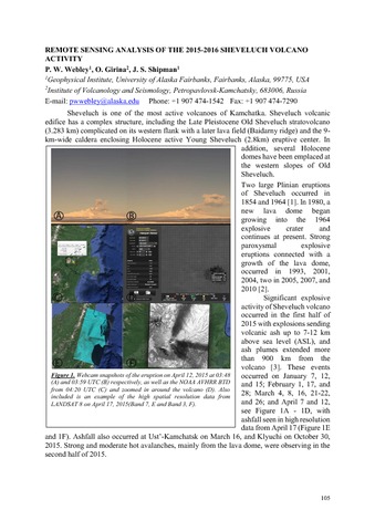
Webley P, Girina O.A., Shipman J Remote Sensing Analysis of the 2015-2016 Sheveluch Volcano Activity // 9th Biennial Workshop on Japan-Kamchatka-Alaska Subduction Processes (JKASP 2016). Fairbanks, Alaska: UAF. 2016. P. 105-106.
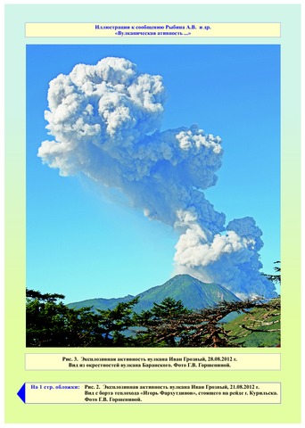
Рыбин А.В., Дегтерев А.В., Чибисова М.В., Гурьянов В.Б., Коротеев И.Г. Вулканическая активность на Курильских островах в 2012-2015 гг. // Вестник КРАУНЦ. Серия: Науки о Земле. 2016. Вып. 30. № 2. С. 77-87.
Annotation
The paper presents data that describe the Kuril Island Arc volcanic activity over the 2012-2015 period collected using satellite monitoring and visual observations, as well as the results of field studies at the active volcanoes. The authors analyzed eruptions of Ivan Grozny, Kudryavy (Iturup Island), Snow (Chirpoi Island), Chirinkotan (Chirinkotan Island), Sinarka (Shiashkotan Island), Chikurachki (Paramushir Island), and Alaid (Atlasov Island) volcanoes.