Kiryukhin A.V., Bergal-Kuvikas O.V., Lemzikov M.V. Magmatic System of Shiveluch Volcano from Seismic Data with Geomechanical Interpretation // Journal of Volcanology and Seismology. 2026. Vol. 20. № 2. P. 136-164. https://doi.org/10.1134/S0742046326700077
Tolstykh M.L., Melnikov D.V., Babansky A.D. Dacitic Ash from the Andesitic Sheveluch Volcano, Kamchatka // Journal of Volcanology and Seismology. 2026. Vol. 20. № 1. P. 31-50. https://doi.org/10.1134/S0742046325700642
Аннотация
Sheveluch Volcano is one of the most productive volcanoes in Kamchatka, characterized during the Holocene by alternating periods of predominantly extrusive and explosive activity. New data on the volumetric parameters of fine ash emissions have been obtained, indicating that the mass of erupted material of dacitic composition during a single moderate-strength eruption can exceed 2 million tons. In those years when gas and ash cloud eruptions were particularly frequent (sometimes more than twenty per month), the total mass of fine dacitic ash can be comparable to the annual discharge of andesitic material (extrusive lavas and tephra), providing a new perspective on the genesis of andesites.
Бахматова Я.А., Озеров А.Ю., Мельников Д.В. Первые результаты эксплуатации вулканологического многопараметрического автоматизированного комплекса (ВМАК) на Авачинском вулкане // Вулканизм и связанные с ним процессы. Материалы XXIX научной конференции, посвященной Дню вулканолога, 30 марта - 4 апреля 2026 г. Петропавловск-Камчатский: ИВиС ДВО РАН. 2026. С. 19-22.
Аннотация
Представлены первые результаты эксплуатации ВМАК на Авачинском вулкане (Камчатка, Россия). В ходе непрерывного мониторинга с 28.08.2025 г. по настоящее время (февраль 2026 г.) комплекс обеспечивает передачу данных в реальном времени в приемно-аналитический центр ИВиС ДВО РАН.
Бергаль-Кувикас Ольга, Чугаев А.В., Ларионова Ю.О., Окина О.И. Происхождение и эволюция магм моногенного конуса г. Шлаковая (Малко-Петропавловская зона поперечных дислокаций) // Вулканизм и связанные с ним процессы. Материалы XXIX научной конференции, посвященной Дню вулканолога, 30 марта - 4 апреля 2026 г. Петропавловск-Камчатский: ИВиС ДВО РАН. 2026. С. 27-29.
Гирина О.А. Вулкан Ключевской: боковой прорыв 2025 г. – миф или реальность // Вулканизм и связанные с ним процессы. Материалы XXIX научной конференции, посвященной Дню вулканолога, 30 марта - 4 апреля 2026 г. Петропавловск-Камчатский: ИВиС ДВО РАН. 2026. С. 42-45.
Аннотация
В работе описана активность вулкана Ключевской в 2025 г., в том числе его деятельность после окончания вершинного извержения.
Гирина О.А., Маневич А.Г., Мельников Д.В., Романова И.М., Нуждаев А.А., Лупян Е.А., Сорокин А.А., Крамарева Л.С., Королев С.П., Демянчук Ю.В. Активность вулканов Камчатки и Курил в 2025 г. и их опасность для авиации // Вулканизм и связанные с ним процессы. Материалы XXIX научной конференции, посвященной Дню вулканолога, 30 марта - 4 апреля 2026 г. Петропавловск-Камчатский: ИВиС ДВО РАН. 2026. С. 46-49.
Аннотация
В работе описана активность вулканов Камчатки и Курил в 2025 г. Эксплозивные извержения вулканов Шивелуч, Ключевской и Безымянный представляли опасность для международных и местных авиаперевозок, Карымский, Крашенинникова и Эбеко − для местных авиаперевозок.
Гирина О.А., Мельников Д.В., Маневич А.Г., Романова И.М., Лупян Е.А., Сорокин А.А., Крамарева Л.С., Королев С.П. Активность вулкана Крашенинникова (Камчатка) в 2025-2026 гг. // Вулканизм и связанные с ним процессы. Материалы XXIX научной конференции, посвященной Дню вулканолога, 30 марта - 4 апреля 2026 г. Петропавловск-Камчатский: ИВиС ДВО РАН. 2026. С. 50-53.
Аннотация
В работе описана активность вулкана Крашенинникова в 2025-2026 гг. Первое историческое извержение вулкана началось 2 августа 2025 г. и продолжается до настоящего времени.
Гирина О.А., Мельников Д.В., Маневич А.Г., Романова И.М., Сергеева А.В., Лупян Е.А., Сорокин А.А., Крамарева Л.С., Цветков В.А., Демянчук Ю.В. Пароксизмальные эксплозивные извержения вулкана Безымянный в 2025 г. // Вулканизм и связанные с ним процессы. Материалы XXIX научной конференции, посвященной Дню вулканолога, 30 марта - 4 апреля 2026 г. Петропавловск-Камчатский: ИВиС ДВО РАН. 2026. С. 54-57.
Аннотация
В работе описана активность вулкана Безымянный в 2025 г. и состав тефры извержений. Произошло два пароксизмальных эксплозивных извержения вулкана в апреле и ноябре, они представляли опасность для международных и местных авиаперевозок.
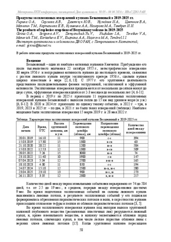
Гирина О.А., Сергеева А.В., Демянчук Ю.В., Нуждаев И.А., Цветков В.А., Маневич А.Г., Карташева Е.В., Кузьмина А.А., Назарова М.А., Тембрел И.И. Продукты эксплозивных извержений вулкана Безымянный в 2019-2025 гг. // Вулканизм и связанные с ним процессы. Материалы XXIX научной конференции, посвященной Дню вулканолога, 30 марта - 4 апреля 2026 г. Петропавловск-Камчатский: ИВиС ДВО РАН. 2026. С. 58-61.
Литвинова Н.В., Бергаль-Кувикас О.В., Долгая А.А. Влияние антропогенных и природных факторов на динамику посещения Мутновского вулкана и его окрестностей // Вулканизм и связанные с ним процессы. Материалы XXIX научной конференции, посвященной Дню вулканолога, 30 марта - 4 апреля 2026 г. Петропавловск-Камчатский: ИВиС ДВО РАН. 2026. С. 332-335.