Романова И.М., Зеленин Е.А., Михайлюкова П.Г., Пономарева В.В. Геопортал Института вулканологии и сейсмологии ДВО РАН и геосервис «Голоценовый вулканизм Камчатки» // Геодезия и картография. 2015. № 8. С. 17-23. doi: 10.22389/0016-7126-2015-902-8-17-23.
Annotation
Development of spatial data infrastructure (SDI) is one of the modern trends of geoinformation technologies. SDI of the Institute of Volcanology and Seismology (IVS) FEB RAS has been developing since 2008. Metadata management system, storage and management of spatial data system and geoportal are the main elements of the SDI. Metadata management system provides powerful tools for creation, editing, browsing of metadata, efficient instruments for searching for data and services. The geoportal is a single point of access to metadata catalogue, collections of volcanological and seismological data, and geoservices. One of the collections is available in the Volcanoes of Kurile-Kamchatka Island Arc (VOKKIA) information web system, which integrates available volcanological data related to the volcanoes in Kamchatka, the Kurile Islands and adjacent seas. Today the VOKKIA system includes the sections: Volcanoes, Eruptions, Rocks, Monitoring, Images, Geoservices, Bibliography. Kamchatka Holocene Volcanism geoservice of the VOKKIA system shows the centers of both historic and prehistoric volcanic eruptions, age and composition of deposits etc. This paper gives a detailed description of development and core capabilities of the geoservice. Based on the international OGC standards, the geoservices allow the wider range of users to access the spatial data in contrast with the desktop GIS. Spatial metadata, data and geoservices published on the IVS FEB RAS Geoportal can be easily found through the Internet and are available for the international scientific society contributing into increased rate of data exchange between researchers.
Романова И.М., Мелекесцев И.В., Гирина О.А. Информационная система «Вулканы Курило-Камчатской островной дуги» // Проблемы комплексного геофизического мониторинга Дальнего Востока России. Труды Третьей научно-технической конференции, Петропавловск-Камчатский, 9-15 октября 2011 г. Обнинск: ГС РАН. 2011. С. 395-398.
Романова И.М., Рашидов В.А., Бондаренко В.И., Палуева А.А. Геоинформационная система «Геомагнитные исследования подводных вулканов Курильской островной дуги» // Проблемы комплексного геофизического мониторинга Дальнего Востока России. Труды Второй региональной научно-технической конференции. Петропавловск-Камчатский, 11-17 октября 2009 г. Петропавловск-Камчатский: ГС РАН. 2010. С. 288-292.
Рудич К.Н. О соотношении субвулканических образований с магматическими породами других фаций (на примере хребта Сарычева) // Труды Лаборатории вулканологии АН СССР. 1962. Вып. 21. С. 57-64.
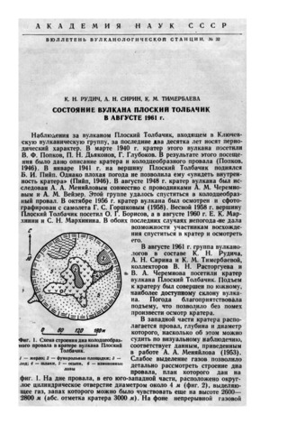
Рудич К.Н., Сирин А.Н., Тимербаева К.М. Состояние вулкана Плоский Толбачик в августе 1961 г. // Бюллетень вулканологической станции. 1961. № 32. С. 20-22.
Рыбалов Б.Л. О происхождении некоторых туфолав юго-западных отрогов Северного Тянь-Шаня // Труды Лаборатории вулканологии АН СССР. 1957. Вып. 14. С. 48-67.
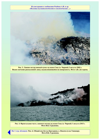
Рыбин А.В., Богомолов Л.М., Дегтерев А.В., Чибисова М.В., Копанина А.В., Власова И.И., Гурьянов В.Б., Коротеев И.Г., Давыдова М.Ю., Климанцов И.М. Полевые вулканологические и экологические исследования на Курильских островах в 2015 г. // Вестник КРАУНЦ. Серия: Науки о Земле. 2015. Вып. 28. № 4. С. 94-99.
Рыбин А.В., Дегтерев А.В., Кравчуновская Е.А., Чибисова М.В., Нерода А.С., Мелекесцев И.В., Разжигаева Н.Г., Чащин А.А., Чирков С.А., Коротеев И.Г., Арсланов Х.А. Слабое фреатическое извержение вулкана Экарма (Курильские о-ва) в июне 2010 г. как возможный предвестник его будущего сильного магматического извержения // Вулканология и сейсмология. 2012. № 5. С. 13-24.
Annotation
We provide data concerning a weak phreatic eruption of Ekarma Volcano on Ekarma Island, in the Kurils, in June 2010. The ash plumes did not rise higher than 3 km above sea level. A preliminary estimate of the volume of erupted resurgent material (mostly tephra) is on order 2 х 10^5 м^3. Reconstruction of the volcano's history and the dynamics of its eruptive activity for the last 4500-5000 years suggests that a larger eruption can occur during the next few decades that will discharge juvenile pyroclastics and/or lava.
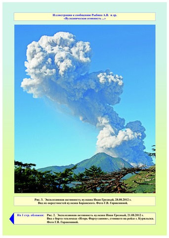
Рыбин А.В., Дегтерев А.В., Чибисова М.В., Гурьянов В.Б., Коротеев И.Г. Вулканическая активность на Курильских островах в 2012-2015 гг. // Вестник КРАУНЦ. Серия: Науки о Земле. 2016. Вып. 30. № 2. С. 77-87.
Annotation
The paper presents data that describe the Kuril Island Arc volcanic activity over the 2012-2015 period collected using satellite monitoring and visual observations, as well as the results of field studies at the active volcanoes. The authors analyzed eruptions of Ivan Grozny, Kudryavy (Iturup Island), Snow (Chirpoi Island), Chirinkotan (Chirinkotan Island), Sinarka (Shiashkotan Island), Chikurachki (Paramushir Island), and Alaid (Atlasov Island) volcanoes.