Гирина О.А., Лупян Е.А., Мельников Д.В., Кашницкий А.В., Уваров И.А., Бриль А.А., Константинова А.М., Бурцев М.А., Маневич А.Г., Гордеев Е.И., Крамарева Л.С., Сорокин А.А., Мальковский С.И., Королев С.П. Создание и развитие информационной системы «Дистанционный мониторинг активности вулканов Камчатки и Курил» // Современные проблемы дистанционного зондирования Земли из космоса. 2019. Т. 16. № 3. С. 249-265. https://doi.org/10.21046/2070-7401-2019-16-3-249-265.
Annotation
In 2011, the experts of the Institute of Volcanology and Seismology FEB RAS in cooperation with Space Research Institute RAS, Far-Eastern Center of SRC Planeta and Computing Center FEB RAS created the first version of the information system named “Remote Monitoring of Kamchatka and Kuril Islands Volcanic Activity” (IS VolSatView). The system provides experts with access to a variety of information, including long-term archives of remote sensing data needed for remote monitoring of volcanic activity. A number of web interfaces are developed to deal with the data provided by the system. They enable comprehensive data analysis and processing. However working with the system does not require any specialized desktop applications, but only a web browser and Internet connection to use the system. Since the launch of the system, the list of available data, as well as tools for their analysis, has been continuously expanding. By now, there is a lot of experience in daily use of the system by the experts in volcanology and for solving various problems in the studies of volcanoes and volcanic activity. This article describes the current state of the system, including recent developments, such as determination of the height of ash plumes, improvement of the time series analysis tools, implementation of specialized data processing products.
Гирина О.А., Лупян Е.А., Уваров И.А., Крамарева Л.С. Извержение вулкана Райкоке 21 июня 2019 года // Современные проблемы дистанционного зондирования Земли из космоса. 2019. Т. 16. № 3. С. 303-307. https://doi.org/10.21046/2070-7401-2019-16-3-303-307.
Annotation
Raikoke stratovolcano is located in the Central Kuril Islands, with a height of 551 m (or 2500 m from the bottom of the sea), it has a crater on its peak with a diameter of 700 m and a depth of 200 m, the composition of its rocks is andesites. The island-volcano Raikoke together with the underwater volcano 3.18 is a single volcanic massif of 19×8 km in size, the distance between their peaks is about 7 km. The relative height of the underwater volcano from the bottom of the sea is about 900 m, its top is at a depth of about 250 m, the composition of the rocks of the underwater volcano is andesibasalts and andesites. There were only two known strong eruptions of Raikoke: in 1778 and on 15 February 1924. The current explosive eruption of Raikoke volcano began at 18:05 GMT on 21 June 2019. The first message about the eruption was transmitted by Tokyo VAAC; the information about the development of the eruption based on various satellites was obtained by us using the information system “Remote monitoring of the activity of volcanoes of Kamchatka and the Kuriles (VolSatView)”. According to the Himawari-8 satellite data (http://volcanoes.smislab.ru/animation/1561927182.webm), the main phase of the eruption began with a series of large explosions that raised ash to 10–13 km above sea level, and lasted about 15 hours, forming a powerful eruptive cloud moving over 2500 km North-East from the volcano. On 30 June, the aerosol clouds from Raikoke were observed at distances from the volcano: 3100 km (Novosibirsk Islands), 3500 km (Lake Baikal), about 5500–6000 km (Northwest Canada). A detailed analysis of satellite information suggested that on 24–25 June a lava flow began to pour out on the western slope of Raikoke. It is also possible that during the eruption of Raikoke, the underwater volcano 3.18 also erupted.
Хренов А.П. Современный базальтовый вулканизм Камчатки (результаты аэрокосмических и петрологических исследований). 2003. Дисс. докт. геол.-мин. наук. 203 с.
Мархинин Е.К., Подклетнов Н.Е. Явление образования предбиологических соединений при извержении вулкана Толбачик // Доклады АН СССР. 1977. Т. 235. № 5. С. 1203-1206.
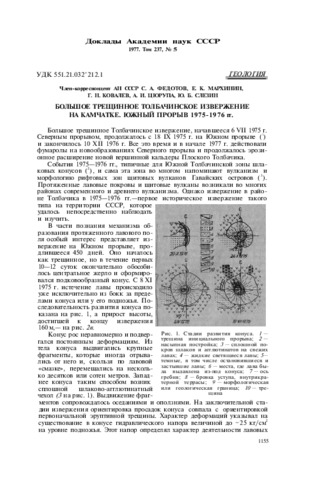
Федотов С.А., Мархинин Е.К., Ковалёв Г.Н., Цюрупа А.И., Слезин Ю.Б. Большое трещинное Толбачинское извержение на Камчатке. Южный прорыв 1975-1976 гг. // Доклады АН СССР. 1977. Т. 237. № 5. С. 1155-1158.
Максимов А.П., Фирстов П.П., Чернев И.И. Закономерности вариаций газового состава скважин Мутновской ГеоЭС в 2018 г. // Вулканизм и связанные с ним процессы. Материалы XXII Всероссийской научной конференции, посвящённой Дню вулканолога, 28-29 марта 2019 г. Петропавловск-Камчатский: ИВиС ДВО РАН. 2019. С. 198-201.
Хубуная С.А., Гонтовая Л.И., Максимов А.П., Хубуная В.С. О гетерогенности мантии и магматических камерах под Ключевской группой вулканов (Камчатка) // Вулканизм и связанные с ним процессы. Материалы XXII Всероссийской научной конференции, посвящённой Дню вулканолога, 28-29 марта 2019 г. Петропавловск-Камчатский: ИВиС ДВО РАН. 2019. С. 120-123.
Annotation
Исследованы минералогические и геохимические особенности умереннокалиевых и субщелочных базальтоидов Ключевской группы вулканов. Изучены природнозакаленные стекла расплавных включений в отношении Fe, Mg, Al, Ca, S, Cl в оливинах шлаковых лапилли вулкана Ключевской. Под вулканом Ключевской предполагается малоглубинный магматический очаг. Радиогенные изотопные отношения Sr, Nd и Pb в К-трахиандезибазальтах указывают на их мантийное происхождении. Оценка условий образования исходных умереннокалиевых и субщелочных расплавов свидетельствует о разной глубине и разной степени плавления мантии при их образовании.