Мархинин Е.К., Сидоров С.С. Систематическое описание гидротермальных проявлений вулканов Эбеко и Влодавца по состоянию на 1959—1960 гг. / Опыт комплексного исследования района современного и новейшего вулканизма (на примере хр. Вернадского о. Парамушир). Труды СахКНИИ СО АН СССР. Южно-Сахалинск: Дальневост. кн. изд-во. 1966. Вып. 16. С. 135-147.
Мархинин Е.К., Стратула Д.С. Некоторые новые данные о вулканах Курильских островов / Четвертичный вулканизм некоторых районов СССР. М.: Наука. 1965. С. 14-28.
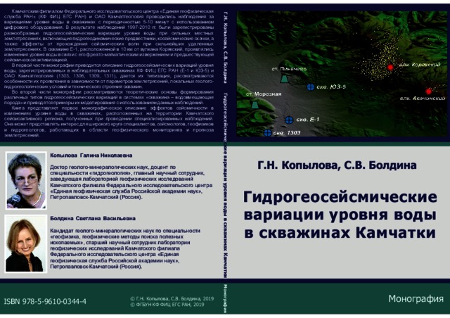
Копылова Г.Н., Болдина С.В. Гидрогеосейсмические вариации уровня воды в скважинах Камчатки. Петропавлоск-Камчатский: ООО "Камчатпресс". 2019. 144 с.
Annotation
Камчатским филиалом Федерального исследовательского центра «Единая геофизическая служба РАН» (КФ ФИЦ ЕГС РАН) и ОАО Камчатгеология проводились наблюдения за вариациями уровня воды в скважинах с периодичностью 5-10 минут с использованием цифрового оборудования. В результате наблюдений 1997-2010 гг. были зарегистрированы разнообразные гидрогеосейсмические вариации уровня воды при сильных местных землетрясениях, включающие гидрогеодинамические предвестники, косейсмические скачки, а также эффекты от прохождения сейсмических волн при сильнейших удаленных землетрясениях. В скважине Е-1, расположенной в 10 км от вулкана Корякский, проявлялись изменения уровня воды в связи с его фреатомагматическим извержением и предшествующей сейсмической активизацией.
В первой части монографии приводится описание гидрогеосейсмических вариаций уровня воды, зарегистрированных в наблюдательных скважинах КФ ФИЦ ЕГС РАН (Е-1 и Ю З-5) и ОАО Камчатгеология (1303, 1306, 1309, 1311), дается их типизация, рассматриваются особенности их проявления в зависимости от параметров землетрясений, локальных геолого-гидрогеологических условий и технического строения скважин.
Во второй части монографии рассматриваются теоретические основы формирования различных типов гидрогеосейсмических вариаций в системах «скважина – водовмещающая порода» и приводятся примеры их моделирования с использованием данных наблюдений.
Книга представляет первое монографическое описание эффектов сейсмичности в изменениях уровня воды в скважинах, расположенных на территории Камчатского сейсмоактивного региона, полученных при проведении специализированных наблюдений. Она может представлять интерес для широкого
круга специалистов, сейсмологов, геофизиков и гидрогеологов, работающих в области геофизического мониторинга и прогноза землетрясений.
Гирина О.А., Лупян Е.А., Сорокин А.А., Мельников Д.В., Маневич А.Г., Кашницкий А.В., Уваров И.А., Балашов И.В., Романова И.М., Марченков В.В., Константинова А.М., Крамарева Л.С., Мальковский С.И., Королев С.П. Основные результаты 2019 г. комплексного мониторинга вулканов Камчатки и Курил с помощью информационной системы VolSatView // Материалы 17-ой Всероссийской открытой конференции "Современные проблемы дистанционного зондирования Земли из космоса". М.: ИКИ РАН. 2019. https://doi.org/10.21046/17DZZconf-2019a.
Гирина О.А., Мельников Д.В., Лупян Е.А., Маневич А.Г., Нуждаев А.А., Крамарева Л.С. Сильное эксплозивное извержение вулкана Райкоке (Курилы) в 2019 г. // Материалы 17-ой Всероссийской открытой конференции "Современные проблемы дистанционного зондирования Земли из космоса". М.: ИКИ РАН. 2019. https://doi.org/10.21046/17DZZconf-2019a.
Гирина О.А., Мельников Д.В., Маневич А.Г., Мальковский С.И., Сорокин А.А., Уваров И.А., Марченков В.В., Кашницкий А.В., Крамарева Л.С., Нуждаев А.А. Анализ извержений вулкана Безымянный в 2019 г. с помощью дистанционных методов исследований // Материалы 17-ой Всероссийской открытой конференции "Современные проблемы дистанционного зондирования Земли из космоса". М.: ИКИ РАН. 2019. https://doi.org/10.21046/17DZZconf-2019a.
Гирина О.А., Романова И.М., Мельников Д.В., Маневич А.Г., Лупян Е.А., Сорокин А.А., Крамарева Л.С., Уваров И.А., Кашницкий А.В., Константинова А.М., Мальковский С.И., Королев С.П. Анализ эксплозивных извержений вулканов Камчатки и Курил с помощью информационных технологий // Информационные технологии и высокопроизводительные вычисления. Материалы V Международной научно-практической конференции. Хабаровск, 16-19 сентября 2019 г. Хабаровск: Тихоокеанский государственный университет. 2019. С. 18-23.
Annotation
Daily monitoring of Kamchatka volcanoes has been carried out since 1993, Kuril - since 2003. Since 2009, using modern information technologies and methods, informa tion systems equipped with modern tools for data analysis have been developed, with the help of which there are carried out in the IVS FEB RAS comprehensive studies of volcanogenic processes in the Kuril - Kamchatka region, including the most dangerous explosive eruptions for humans, as well as products of volcanic eruptions. The created systems allow volcanologists to work with various satellite data together with weather and video information for continuous monitoring and research of volcanic activity; simulate the spread of ash clouds and plumes to assess their danger to aviation; combine and systematize various information about volcanoes and their eruptions.
Романова И.М., Гирина О.А., Маневич А.Г., Мельников Д.В., Горбач Н.В. Информационные системы VOKKIA и KVERT для анализа активности вулканов Камчатки и Курил // Информационные технологии и высокопроизводительные вычисления. Материалы V Международной научно-практической конференции. Хабаровск, 16-19 сентября 2019 г. Хабаровск: Тихоокеанский государственный университет. 2019. С. 278-282.
Annotation
A large amount of unique scientific data about the Kamchatka and the Kurile Island Arc volcanoes has been collected in the Institute of Volcanology and Seismology FEB RAS. The paper describes VOKKIA and KVERT information web-systems. VOKKIA is designed to integration and systematization of heterogeneous scientific data on the terrestrial and submarine volcanoes of Kurile-Kamchatka Island Arc including data on their eruptions. The KVERT system provides collection and storage of operational data of monitoring of active volcanoes. Besides, the article describes graphical visualization services that helps to detect the relationship, patterns and trends in volcanic processes over time.
Мальковский С.И., Сорокин А.А., Гирина О.А. Развитие информационной системы численного моделирования распространения пепловых облаков от вулканов Камчатки и Курил // Вычислительные технологии. 2019. Т. 24. № 6. С. 79-89. https://doi.org/10.25743/ICT.2019.24.6.010.
Annotation
Purpose. Ash clouds and plumes arising due to explosive eruptions of the volcanoes of Kamchatka and the Kuril Islands pose a great danger to aviation flights. In this regard, the urgent and important task is to predict and analyze distribution of volcanic ash in the atmosphere . To solve this task, AIS "Signal"was designed. It includes a modelling subsystem using the PUFF model. It allows predicting the direction, speed and height of the propagation of ash clouds and plumes in the atmosphere. At the same time, for more accurate assessment of the danger of ash clouds and plumes, it is necessary to determine not only their qualitative, but also quantitative characteristics, for example, the concentration of ash at the flight levels of aircrafts, the amount of ash deposited on the surface, etc. To solve this problem, research was done to expand the capabilities of the AIS "Signal"by integrating the Eulerian FALL3D model into it. The present article presents the results of this work.
Methodology. Implementation of system and user interfaces for automating the processes of collecting and preparing auxiliary data (reference information about volcanoes, meteorological data, etc.), performing numerical calculations in the FALL3D model and visualizing the obtained results both were carried out on the basis of similar interfaces created earlier in AIS “Signal” for the PUFF model. All these features significantly accelerate the process of integration the FALL3D model into the existing AIS modelling subsystem. Implementation of the operating modes of the subsystem and evaluating the efficiency of its functioning were carried out as part of the study of ash clouds and plumes propagation which are formed during explosive events of the Kamchatka volcanoes.
Findings. As part of the integration of the FALL3D model into the modelling subsystem, informational interaction of its software components with the services of AIS “Signal” was organized. Algorithms for the formation of collections of meteorological data necessary for the functioning of the model were proposed and implemented. User interfaces have been created that allow specialists to calculate the characteristics of ash clouds with the ability to set detailed initial parameters for an explosive event and model settings.
Originality. The integration of the FALL3D model in the AIS “Signal” significantly expands its ability to predict propagation of ash clouds and plumes formed during explosive eruptions of the volcanoes of Kamchatka and the Kuril Islands. In addition to the instruments for determining the direction, speed, and height of the spread of volcanic ash, tools have been developed to determine the ash concentration at the flight levels of aircrafts, as well as the thickness and mass of the ash falling on the surface of the Earth. Numerical experiments have showed a good agreement between Originality. The integration of the FALL3D model in the AIS “Signal” significantly expands its ability to predict propagation of ash clouds and plumes formed during explosive eruptions of the volcanoes of Kamchatka and the Kuril Islands. In addition to the instruments for determining the direction, speed, and height of the spread of volcanic ash, tools have been developed to determine the ash concentration at the flight levels of aircrafts, as well as the thickness and mass of the ash falling on the surface of the Earth. Numerical experiments have showed a good agreement between the obtained modelling results and the satellite data.the obtained modelling results and the satellite data.
Мархинин Е.К. О приуроченности парогидротермальных проявлений на острове Кунашир к разрывным нарушениям // Бюллетень вулканологической станции. 1956. № 24. С. 39-46.