Мархинин Е.К., Божкова Л.И. Зависимость химического состава термальных вод от сейсмической активности // Бюллетень вулканологических станций. 1976. № 52. С. 37-41.
Степанов В.В., Чирков А.М. Активность вершинного кратера Ключевского вулкана в январе – марте 1980 г. // Вулканология и сейсмология. 1981. № 1. С. 103-105.
Абдурахманов А.И., Злобин Т.К., Мархинин Е.К., Тараканов Р.З. Извержение вулкана Иван Грозный в 1989 г. // Вулканология и сейсмология. 1990. № 4. С. 3-9.
Annotation
Recent activity of the volcano is associated with its multiaction central effusion dome. The N—N—E top of this dome has a crater of the specific shape with a radial fissure 250—270 m long and 15—70 m wide. Small phreatic eruptions were noted in 1951, 1968, 1970, and 1973. The eruption of 1989 started on May 3. Explosions produced ash-gas cloud which rose to a height of 1,5 km on May 8. The very first explosions were followed by formation of a new fissure on the northern flank of the volcano, its length being about 70 m. The eruption was preceded by earthquakes which occurred beneath the volcano and were oriented across the strike of the Kuril Island arc. These earthquakes can be subdivided into two groups with focal depths close to 30 km and 60— 80 km. The layer between the depths from 30 to 55—60 km seems to be aseismic indicating that in the depth range of 30—60 km beneath the volcano a magma chamber can be present. It is suggested that current intensified activity of the volcano has been caused by tectonic movements associated with transverse faulting. A sort-term forecast of the volcano activity is presented.
Мархинин Е.К. Прогнозное определение зон вулканической опасности // Вулканизм и связанные с ним процессы. Геотермия, действующие гидротермальные системы и рудообразование. Тезисы докладов VI Всесоюзного вулканологического совещания, Петропавловск-Камчатский, сентябрь 1985 г. Петропавловск-Камчатский: АН СССР ДВНЦ Институт вулканологии. 1985. Вып. 3. С. 245-247.
Будников В.А., Мархинин Е.К., Овсянников А.А. Количество, распространение и петрохимические особенности пирокластики Большого трещинного Толбачинского извержения / Геологические и геофизические данные о Большом трещинном Толбачинском извержении 1975-1976 гг.. М.: Наука. 1978. С. 32-43.
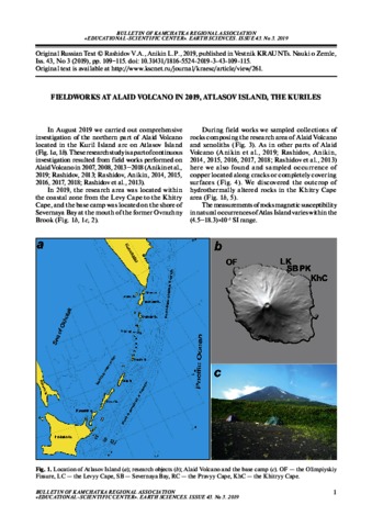
Рашидов В.А., Аникин Л.П. Полевые работы на вулкане Алаид (о. Атласова, Курильские острова) в 2019 году // Вестник КРАУНЦ. Серия: Науки о Земле. 2019. Вып. 43. № 3. С. 109-115. doi: 10.31431/1816-5524-2019-3-43-109-115.
Блох Ю.И., Бондаренко В.И., Долгаль А.С., Новикова П.Н., Петрова В.В., Пилипенко О.В., Рашидов В.А., Трусов А.А. Комплексные геолого-геофизические исследования подводного вулканического массива Архангельского (Курильская островная дуга) // Вестник КРАУНЦ. Серия: Науки о Земле. 2019. Вып. 44. № 4. С. 35-50. doi: 10.31431/1816-5524-2019-4-44-35-50.
Annotation
The article presents the results of integrated geologic-geophysical investigation of the Arkhangelsky submarine volcanic massif, which is located in the Bussol Strait in the central zone of the Kurile Island Arc. The massif consists of amalgamated and eroded volcanic edifices and is built up of endogenous basalts and exogenous tuffs. Rocks and minerals to the exclusion of quartz are hydrothermally altered; moreover they were altered after the formation of tuff. High values of the natural remnant magnetization of dredged rocks are caused by the high content of single-domain and pseudo-single-domain grains of titanomagnetite and magnetite. The Arkhangelsky massif most likely was formed during periods of global geomagnetic disturbances. The authors have revealed feeders of the near-vertical and southeastern trends and causative magnetic blocks with different geometric and magnetic characteristics in the edifice of the massif. A peripheral magma chamber has been revealed between depths of 1100–1200 m. At the southeast foot of the massif we found large landslide blocks.