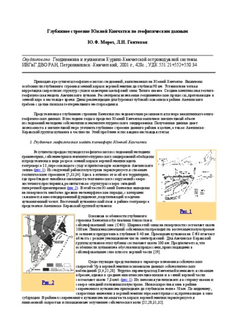
Мороз Ю.Ф., Гонтовая Л.И. Глубинное строение Южной Камчатки по геофизическим данным / Геодинамика и вулканизм Курило-Камчатской островодужной системы. Петропавловск-Камчатский: ИВГиГ ДВО РАН. // Геодинамика и вулканизм Курило-Камчатской островодужной системы. Петропавловск-Камчатский: ИВГиГ ДВО РАН. 2001. С. 58-74.
Аннотация
Приводятся результаты геофизических исследований, выполненных на Южной Камчатке. Выявлены особенности глубинного строения земной коры и верхней мантии до глубины 90 км. Установлена четкая корреляция скоростных структур суши и акватории шельфовой зоны Тихого океана. Создана комплексная геолого-геофизическая модель Авачинского вулкана. Рассмотрены возможные геодинамические процессы, протекающие в земной коре в настоящее время. Даны рекомендации для бурения глубокой скважины в районе Авачинского грабена с целью поисков геотермального месторождения.
Представления о глубинном строении Камчатки последовательно развиваются по мере накопления геолого-геофизических данных. В последние годы в пределах Южной Камчатки выполнен значительный объем исследований методами сейсмологии и магнитотеллурического зондирования. Полученные данные дают возможность в значительной мере уточнить глубинное строение данного района в целом, а также Авачинско-Корякской группы вулканов в частности. Этой проблеме и посвящена настоящая статья.
Апрелков С.Е. Вулкан Кошелева / По Камчатке (к 225-летию Петропавловска-Камчатского). Петропавловск-Камчатский: Дальиздат. 1965. С. 104-106.
Гирина О.А., Маневич А.Г., Мельников Д.В., Нуждаев А.А., Романова И.М., Лупян Е.А., Сорокин А.А., Крамарева Л.С. Активность вулканов Камчатки и Курильских островов в 2020-2021 гг. и их опасность для авиации // Вулканизм и связанные с ним процессы. Материалы XXIV ежегодной научной конференции, посвящённой Дню вулканолога, 29-30 марта 2021 г. Петропавловск-Камчатский: ИВиС ДВО РАН. 2021. С. 25-28.
Гирина О.А., Мельников Д.В., Маневич А.Г., Нуждаев А.А., Романова И.М., Лупян Е.А., Кашницкий А.В., Сорокин А.А., Крамарева Л.С. Эксплозивное извержение вулкана Безымянный 21 октября 2020 г. // Вулканизм и связанные с ним процессы. Материалы XXIV ежегодной научной конференции, посвящённой Дню вулканолога, 29-30 марта 2021 г. Петропавловск-Камчатский: ИВиС ДВО РАН. 2021. С. 29-31.
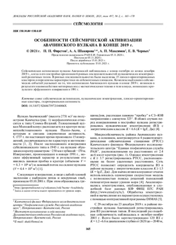
Фирстов П.П., Шакирова А.А., Максимов А.П., Черных Е.В. Особенности сейсмической активизации Авачинского вулкана в конце 2019 г. // Доклады Российской Академии наук. Науки о Земле. 2021. Т. 497. № 2. С. 165-170. doi: 10.31857/S268673972104006X.
Аннотация
Сейсмическая активизация вулкана Авачинский наблюдалась с конца октября до конца декабря 2019 г., когда в его постройке произошло 6 роевых последовательностей вулканических землетрясений различных типов. В роевых последовательностях были выделены 15 плоско-ориентированных кластеров и определены характеристики их сейсмогенных площадок. Комплексный анализ сейсмических событий указывает на то, что активизация Авачинского вулкана в конце 2019 г. возникла в результате взаимодействия метеорных вод с магматическими телами в теле конуса, возникших в результате эффузивного извержения в 1991 г.
Фирстов П.П., Шакирова А.А., Максимов А.П., Черных Е.В. Активизация Авачинского вулкана в 2019 г. // Вулканология и сейсмология. 2021. № 3. С. 1-15. doi: 10.31857/S0203030621030032.
Аннотация
На основании изучения волновых форм и спектрального состава землетрясений, зарегистрированных в период активизации Авачинского вулкана в 2019 г., были выделены три общепринятых типа вулканических землетрясений (ВЗ): вулкано-тектонические, гибридные и длиннопериодные, а также четвертый – “особый” тип ВЗ, отличающийся особенностями волновых форм. Выделены 15 плоско-ориентированных кластеров и определены характеристики сейсмогенных площадок. Анализ сейсмических событий, зафиксированных осенью 2019 г. в Молодом конусе Авачинского вулкана, позволил предположить связь активизации с магматическими телами извержения 1991 г. в теле конуса и их взаимодействием с атмосферными осадками. Наиболее вероятной причиной световых вспышек над кратером, наблюдавшихся 8 декабря, представляется взаимодействие обогащенного водородом вулканического газа при контакте с кислородом воздуха.
Belousov Vladimir, Belousova Irina, Khubaeva Olga Long-lived Volcanic Centers of Kamchatka Geothermal Areas // World Geothermal Congress 2020+1. Reykjavik, Iceland: 2020. С. 1-8.
Аннотация
The current problems of hydrothermal processes and ore-forming systems are volcanic heat sources and mechanisms of heat
transfer. In Pauzhetsky, Semyachik and Mutnovsky geothermal areas in Kamchatka, active long-lived volcanic centers have been
studied, with which high-temperature hydrothermal systems are associated. In the Banno-Paratunsky geothermal area the Paleogene
and Neogene long-lived volcanic centers were identified, with which low-temperature hydrothermal systems are associated. The
geological history of the long-lived volcanic centers development is characterized by changes in their structure as a result of
hydrothermal-magmatic activity. These changes are manifested in the generation and evolution of magma chambers in the mantle
and in the Earth’s crust. Basalt melts of the mantle chambers transport the deep heat to the Earth’s surface through plane magmatic
channels without significant losses. The heat flow of these volcanic centers is short-lived and is characterized by a significant
capacity of ~8,000 kcal/km2s. The long-lived volcanic centers are characterized by the presence of magma chambers in the Earth's
crust. They shield the part of the mantle heat flow. Their thermal capacity on the Earth's surface is estimated from 1000 kcal/km2s
to 5000 kcal/km2s. It is assumed that a significant amount of thermal energy is retained in the long-lived volcanic centers. It is
spent on formation and activity of the chambers as well as the convective hydrothermal ore-forming systems. The evolution of such
centers is accompanied by the formation of complexes of metamorphic rocks which interaction with high-temperature mantle melts
is accompanied by redox reactions like combustion. As a result of these reactions, thermal energy is produced in such magma
chambers. A long-lived jet magmatic system is formed, and it provides the transfer of mantle heat. Heat transfer in the system is
accompanied by minimization of heat losses, accumulation of heat and its additional generation which is necessary for the heat
transfer in the structures with low thermal conductivity. The formation, evolution and extinction of magma chambers and reservoirs
in such heat-conducting structures are controlled by the thermophysical properties of the rocks, their geological structure and redox processes in them.
Girina O.A., Loupian E.A., Ozerov A.Yu., Melnikov D.V., Manevich A.G., Petrova E.G. The Activity of Kamchatka Volcanoes and theirs Danger to Human Society (oral report) // JpGU - AGU Joint Meeting 2021: Virtual. 30 May - 06 July, 2021, Japan, Tokyo. 2021. № C001019.
Аннотация
There are 30 active volcanoes in the Kamchatka, and several of them are continuously active. In the XX-XXI centuries 17 volcanoes of Kamchatka erupted. During this time, 183 volcanic eruptions occurred, including three catastrophic eruptions (Ksudach, 1907; Bezymianny, 1956; Sheveluch, 1964). Strong explosive eruptions of volcanoes were the most dangerous for human society because they produce in a few hours or days to the atmosphere till 2-3 cubic kilometers of volcanic products. Ash plumes and the clouds, depending on the power of the eruptions, the strength and wind speed, to traveled thousands of kilometers from the volcanoes for several days. Any territory of the Kamchatka Peninsula has repeatedly been exposed to ash falls, the thickness of ash in settlements was from less than 1 mm to 4-5 cm. Strong explosive eruptions of volcanoes Sheveluch, Klyuchevskoy, Bezymianny, Kizimen, Karymsky, Zhupanovsky, Avachinsky, Kambalny were the most dangerous for air travel not only over Kamchatka, but also hundreds of kilometers away from the peninsula.
The strong explosive and effusive eruptions of Sheveluch, Klyuchevskoy, Bezymianny, Kizimen and the other were often accompanied by the formation of hot mud flows (lahars), which sometimes disrupted transport communications (roads, bridges) of nearby settlements.
Scientists of KVERT monitor Kamchatkan volcanoes since 1993. Thanks to satellite monitoring of volcanoes carried out by KVERT, several explosive eruptions were predicted in the XXI century, and early warnings were made to the population about possible ashfalls in settlements and about hazard to aviation.
Horváth Á, Carr J.L., Girina O.A., Wu D.L., Bril A.A., Mazurov A.A., Melnikov D.V., Hoshyaripour G.A., Buehler S.A. Geometric estimation of volcanic eruption column height from GOES-R near-limb imagery – Part 1: Methodology // Atmospheric Chemistry and Physics. 2021. Vol. 21. Vol. 16. P. 12189-12206. https://doi.org/10.5194/acp-21-12189-2021, 2021.
Аннотация
A geometric technique is introduced to estimate the height of volcanic eruption columns using the generally discarded near-limb portion of geostationary imagery. Such oblique observations facilitate a height-by-angle estimation method by offering close-to-orthogonal side views of eruption columns protruding from the Earth ellipsoid. Coverage is restricted to daytime point estimates in the immediate vicinity of the vent, which nevertheless can provide complementary constraints on source conditions for the modeling of near-field plume evolution. The technique is best suited to strong eruption columns with minimal tilting in the radial direction. For weak eruptions with severely bent plumes or eruptions with expanded umbrella clouds the radial tilt/expansion has to be corrected for either visually or using ancillary wind profiles. Validation on a large set of mountain peaks indicates a typical height uncertainty of ±500 m for near-vertical eruption columns, which compares favorably with the accuracy of the common temperature method.
Horváth Á, Girina O.A., Carr J.L., Wu D.L., Bril A.A., Mazurov A.A., Melnikov D.V., Hoshyaripour G.A., Buehler S.A. Geometric estimation of volcanic eruption column height from GOES-R near-limb imagery – Part 2: Case studies // Atmospheric Chemistry and Physics. 2021. Vol. 21. Vol. 16. P. 12207-12226. https://doi.org/10.5194/acp-21-12207-2021.
Аннотация
In a companion paper (Horváth et al., 2021), we introduced a new technique to estimate volcanic eruption column height from extremely oblique near-limb geostationary views. The current paper demonstrates and validates the technique in a number of recent eruptions, ranging from ones with weak columnar plumes to subplinian events with massive umbrella clouds and overshooting tops that penetrate the stratosphere. Due to its purely geometric nature, the new method is shown to be unaffected by the limitations of the traditional brightness temperature method, such as height underestimation in subpixel and semitransparent plumes, ambiguous solutions near the tropopause temperature inversion, or the lack of solutions in undercooled plumes. The side view height estimates were in good agreement with plume heights derived from ground-based video and satellite stereo observations, suggesting they can be a useful complement to established techniques.