Kiryukhin A.V., Fedotov S.A., Kiryukhin P.A. Magmatic Systems and the Conditions for Hydrothermal Circulation at Depth in the Klyuchevskoi Volcanic Cluster as Inferred from Observations of Local Seismicity and Thermo-Hydrodynamic Simulation // Journal of Volcanology and Seismology. 2018. Vol. 12. № 4. P. 231-241. doi:10.1134/S0742046318040036.
Annotation
An analysis of local seismicity within the Klyuchevskoi Volcanic Cluster and Shiveluch Volcano for the period 2000–2017 revealed a sequence of plane-oriented earthquake clusters that are interpreted here as the emplacement of dikes and sills (magmatic fracking). The geometry of magma bodies reflects the geomechanical conditions in volcanic plumbing systems and at the bases of the volcanoes. Magmatic fracking within active magmatic plumbing systems results in the formation of permeable reservoirs whose vertical extent can reach 35 km (Klyuchevskoi) and can be as wide as 15 km across (Shiveluch), depending on the geomechanical condition of the host rocks. These reservoirs will be the arena of subsequent hydrothermal circulation, producing geothermal and ore fields, as well as hydrocarbon fields. TOUGH2-EOS1sc simulation tools were used to estimate the conditions for the formation of hydrothermal reservoirs at temperatures below 1200°С and pressures below 1000 bars.
Kiryukhin A.V., Fedotov S.A., Kiryukhin P.A., Chernykh E.V. Magmatic plumbing systems of the Koryakskii–Avacha Volcanic Cluster as inferred from observations of local seismicity and from the regime of adjacent thermal springs // Journal of Volcanology and Seismology. 2017. Vol. 11. № 5. P. 321-334. doi:10.1134/S0742046317050049.
Annotation
An analysis of local seismicity within the Avacha–Koryakskii Volcanic Cluster during the 2000–2016 period revealed a sequence of plane-oriented earthquake clusters that we interpret as a process of dike and sill emplacement. The highest magmatic activity occurred in timing with the 2008–2009 steam–gas eruption of Koryakskii Volcano, with magma injection moving afterwards into the cone of Avacha Volcano (2010–2016). The geometry of the magma bodies reflects the NF geomechanical conditions (tension and normal faults, Sv >SHmax >Shmin ) at the basement of Koryakskii Volcano dominated by vertical stresses Sv, with the maximum horizontal stress SHmax pointing north. A CFRAC simulation of magma injection into a fissure under conditions that are typical of those in the basement of Koryakskii Volcano (the angle of dip is 60о, the size is 2 × 2 km2, and the depth is –4 km abs.) showed that when the magma discharge is maintained at the level of 20000 kg/s during 24 hours the fissure separation increases to reach 0.3 m and the magma injection is accompanied by shear movements that occur at a rate as high as 2 × 10⁻³ m/s, thus corresponding to the conditions of local seismic events with Mw below 4.5. We are thus able to conclude that the use of planeoriented clusters of earthquakes for identification of magma emplacement events is a physically sound procedure. The August 2, 2011 seismicity increase in the area of the Izotovskii hot spring (7 km from the summit of Koryakskii Volcano), which is interpreted as the emplacement of a dike, has been confirmed by an increase in the spring temperature by 10–12°С during the period from October 2011 to July 2012.
Kochegura V.V., Zubov A.G. Paleomagnetic chronostratigraphy of young eruptive series // Abstracts: generation of major basalt types. August 15-22, 1982. Reykjavik, Island: IAVCEI-IAGC Scientific Assembly. 1982. Vol. 81.
Kochegura V.V., Zubov A.G., Braytseva O.A. Magnetostratigraphy of Kamchatkan Holocene formations of soil and pyroclastics // Volcanology and Seismology. 1990. Vol. 8. № 6. P. 825-849.
Annotation
An account is given of magnetostratigraphic studies of Kamchatkan Holocene formations: the cover of soil and pyroclastics and the rocks of the cinder cones from the flank eruptions of Klyuchevskoi Volcano. А study was made of seven sections of the soil and pyroclastics and of samples from 17 cinder cones. А detailed account is given of the data processing procedure. Consideration is given to the reasons for the established incompleteness of the paleomagnetic record in the sections and it is demonstrated that adequately detailed reconstruction of the history of the geomagnetic 1ield is possible only provided that а study is made of а series of рагаllеl sections. The trajесtory of the geomagnetic field vector over the last 4000 years is determined on the basis of the material on radiocarbon datings. Seven cycles of paleosecular variations are distinguished in the age range investigated; each of these cycles has individual features by which they can be recognised and used for stratigraphic correlation. The, features taken were the direction of rotation of the vector, the shape and size of its loops, and the length of the cycles. Correlation of the sections based on paleomagnetic data was found to be in good agreement with the tephrostratigraphic correlation and enabled corrections to be made to the age of some horizons, including the archeological layers of the primitive settlement at Zhupanovo and the cinder cones. The metachronous magnetization present in some tephra layers was found to be an obstacle to any improvement in the accuracy and detail of magnetochronological reconstructions.
Koloskov A.V., Flerov G.B., Perepelov A.B., Melekestsev I.V., Puzankov M.Yu., Filosofova T.M. Evolution Stages and Petrology of the Kekuknai Volcanic Massif as Reflecting the Magmatismin Backarc Zone of Kuril-Kamchatka Island Arc System. Part 1. Geological Position and Geochemistry of Volcanic Rocks // Journal of Volcanology and Seismology. 2011. Vol. 5. № 5. P. 312-334. doi: 10.1134/S074204631104004X.
Annotation
Выделено пять стадий эволюции четвертичного Кекукнайского вулканического массива (западный фланг Срединного хребта Камчатки): 1) докальдерная трахибазальтовая-андезибазальтовая, 2) экструзивная трахиандезит-трахидацитовая, 3) ранняя трахибазальтовая, 4) средняя гавайит-муджиеритовая (с единичными проявлениями андезибазальтов) и 5) поздняя трахибазальт-гавайит-муджиеритовая (с единичными проявлениями андезитов) - ареального вулканизма. По петрологическим данным среди пород массива выделены островодужный и внутриплитный геохимические типы. Ведущую роль в пет-рогенезисе играла динамика флюидной фазы при подчиненной роли процессов фракционной кристаллизации и гибридизма. Последовательное насыщение пород флюидной фазой в ходе эволюции расплавов было прервано в период кальдерообразования, когда осуществилась экстракция большей части флюидомобильных элементов и кремнезема. Геологические и петрологические материалы свидетельствуют о том, что формирование массива произошло в обстановке задугового вулканического бассейна в условиях начавшегося рифтогенеза, при активном участии компонентов мантийного плюма.
Koloskov A.V., Flerov G.B., Perepelov A.B., Melekestsev I.V., Puzankov M.Yu., Filosofova T.M. The Evolutionary Stages and Petrology of the Kekuknai Volcanic Massif Reflecting the Magmatism in the Backarc Zone of the Kuril-Kamchatka Island Arc System. Part II. Petrologic and Mineralogical Features, Petrogenesis Model // Journal of Volcanology and Seismology. 2013. Vol. 7. № 2. P. 145-169. doi: 10.1134/S0742046313020048.
Annotation
Кекукнайский массив сформировался в результате тектоно-магматической деятельности, выразившейся образованием щитообразного вулкана, кальдерной депрессии с сопутствующим внедрением экструзий, и завершившейся интенсивным посткальдерным ареальным вулканизмом. Проведено детальное рассмотрение особенностей минералогического состава пород массива. Использование уже имеющихся и дополнительно выявленных индикаторных возможностей породообразующих минералов позволило восстановить общую картину эволюции магматических расплавов и условия кристаллизации пород (различная флюидонасыщенность-обводненность и окисленность системы). Существенно островодужные или внутриплитные характеристики в составе пород массива проявлены на разных стадиях развития единой флюидно-магматической системы. Декомпрессионная эволюция материнской глубинной базанитовой магмы была реализована появлением в промежуточных очагах дочерних магм трахибазальтового (докальдерный этап развития системы) или гавайитового (ареальный вулканизм) состава. Дальнейшая эманационно-магматическая дифференциация этих расплавов в сочетании с кристаллизационной дифференциации в условиях меняющейся P-T-f02 обстановки и привела к образованию всего многообразия пород Кекукнайского массива.
Kontorovich A.E., Bortnikova S.B., Karpov G.A., Kashirtsev V.A., Kostyreva E.A., Fomin A.N. Uzon volcano caldera (Kamchatka): A unique natural laboratory of the present-day naphthide genesis // Russian Geology and Geophysics. 2011. Vol. 52. № 8. P. 768 - 772. doi: 10.1016/j.rgg.2011.07.002.
Annotation
Oil shows from the thermal springs of the Uzon volcano caldera have been studied by gas chromatography–mass spectrometry methods. Based on the composition and distribution of biomarker molecules, their genetic identity with the organic matter of Pliocene–Quaternary deposits has been established. It has been shown that the Uzon caldera is a unique natural laboratory of the present-day oil formation from the organic matter of Pliocene–Quaternary sediments. It has been stated that attempts to consider the compounds forming these oil shows as a product of hydrothermal abiogenic synthesis are absolutely unfounded.
Kopylova G.N., Boldina S.V. On the Relationships of Water-Level Variations in the E-1 Well, Kamchatka to the 2008–2009 Resumption of Activity on Koryakskii Volcano and to Large (M ≥ 5) Earthquakes // Journal of Volcanology and Seismology. 2012. Vol. 6. № 5. P. 312-328. doi: 10.1134/S074204631205003X.
Annotation
Abstract—We discuss the water!level variations in the E!1 well for the time period between May 2006 and
2010, inclusive. A trend towards an increasing level at an abnormally high rate occurred from mid!2006 to
December 2009. This increase is regarded as the response of the aquifer of gas!saturated ground water that
exists in the volcanogenic–sedimentary deposits of the Avacha volcano!tectonic depression to volumetric
strain changes during the precursory period and the occurrence of a swarm of small earthquakes ( = 8.3)
in the area of Koryakskii Volcano and to its phreatic eruption. We estimated the volumetric compression as
Δε = –(4.1 × 10⁻⁶–1.5 × 10⁻⁵) from the amplitude of water!level rise using the elastic parameters of the wa!
ter!saturated rocks. While the strain source was active, we observed a decreasing sensitivity of the hydrologic
regime in the well to the precursory processes before large (M ≥ 5.0) tectonic earthquakes.
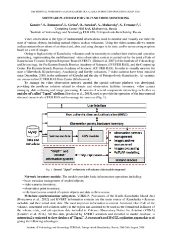
Korolev S.P., Sorokin A.A., Urmanov I.P., Kamaev A., Girina O.A. Classification of Video Observation Data for Volcanic Activity Monitoring Using Computer Vision and Modern Neural NetWorks (on Klyuchevskoy Volcano Example) // Remote Sensing. 2021. Vol. 13. Vol. 23. № 4747. P. 1-20. https://doi.org/10.3390/rs13234747.
Annotation
Currently, video observation systems are actively used for volcano activity monitoring. Video cameras allow us to remotely assess the state of a dangerous natural object and to detect thermal anomalies if technical capabilities are available. However, continuous use of visible band cameras instead of special tools (for example, thermal cameras), produces large number of images, that require the application of special algorithms both for preliminary filtering out the images with area of interest hidden due to weather or illumination conditions, and for volcano activity detection. Existing algorithms use preselected regions of interest in the frame for analysis. This region could be changed occasionally to observe events in a specific area of the volcano. It is a problem to set it in advance and keep it up to date, especially for an observation network with multiple cameras. The accumulated perennial archives of images with documented eruptions allow us to use modern deep learning technologies for whole frame analysis to solve the specified task. The article presents the development of algorithms to classify volcano images produced by video observation systems. The focus is on developing the algorithms to create a labelled dataset from an unstructured archive using existing and authors proposed techniques. The developed solution was tested using the archive of the video observation system for the volcanoes of Kamchatka, in particular the observation data for the Klyuchevskoy volcano. The tests show the high efficiency of the use of convolutional neural networks in volcano image classification, and the accuracy of classification achieved 91%. The resulting dataset consisting of 15,000 images and labelled in three classes of scenes is the first dataset of this kind of Kamchatka volcanoes. It can be used to develop systems for monitoring other stratovolcanoes that occupy most of the video frame.