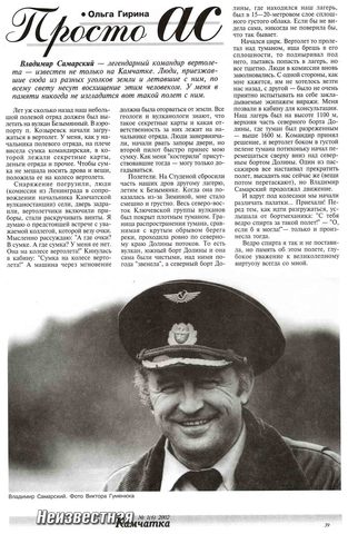
Bibliography
Volcano:
Group by:  
Jump to:     All     Articles     Books     Books sections     Dissertations     Conference Items     Documents     Copyright certificates     Weblinks     Other     
Records: 2683
Articles
Гирина О.А., Лупян Е.А., Мельников Д.В., Маневич А.Г., Нуждаев А.А., Крамарева Л.С., Уваров И.А., Кашницкий А.В., Сорокин А.А., Мальковский С.И., Королев С.П. Результаты мониторинга эксплозивно-эффузивного извержения вулкана Ключевской в 2019-2020 гг. с помощью информационной системы VolSatView // Материалы Восемнадцатой Всероссийской Открытой конференции с международным участием «Современные проблемы дистанционного зондирования Земли из космоса. 16–20 ноября. 2020. М.: ИКИ РАН. 2020. С. 75 https://doi.org/10.21046/18DZZconf-2020a.
Гирина О.А., Лупян Е.А., Мельников Д.В., Маневич А.Г., Нуждаев А.А., Сорокин А.А., Крамарева Л.С., Романова И.М., Кашницкий А.В., Уваров И.А., Мальковский С.И., Королев С.П. Спутниковый мониторинг эксплозивного извержения вулкана Чиринкотан (Северные Курилы) в 2021 г. // Материалы 19-й Международной конференции «Современные проблемы дистанционного зондирования Земли из космоса». Электронный сборник материалов конференции. Москва: ИКИ РАН. 2021. № XIX.G.100. https://doi.org/10.21046/19DZZconf-2021a.
Гирина О.А., Лупян Е.А., Мельников Д.В., Маневич А.Г., Сорокин А.А., Крамарева Л.С., Романова И.М., Нуждаев А.А., Кашницкий А.В., Уваров И.А., Мальковский С.И., Королев С.П. Дистанционный мониторинг вершинного и побочного извержений вулкана Ключевской в 2020-2021 гг. // Материалы 19-й Международной конференции «Современные проблемы дистанционного зондирования Земли из космоса». Электронный сборник материалов конференции. Москва: ИКИ РАН. 2021. № XIX.G.27. https://doi.org/10.21046/19DZZconf-2021a.
Гирина О.А., Лупян Е.А., Мельников Д.В., Маневич А.Г., Сорокин А.А., Крамарева Л.С., Уваров И.А., Кашницкий А.В. Извержение вулкана Безымянный 20 декабря 2017 года // Современные проблемы дистанционного зондирования Земли из космоса. 2018. Т. 15. № 3. С. 88-99. https://doi.org/10.21046/2070-7401-2018-15-3-88-99.
   Annotation
Bezymianny is one of the most active volcanoes in Kamchatka and the world. The intensification of its activity began in December 2016 after four years of silence during 2012–2016. There were three paroxysmal explosive volcanic eruptions in 2017; the paper is devoted to the event on December 20 with ash removal up to 15 km above sea level. We describe the course of the eruption and the results of its analysis, including an animated image of the motion of the ash cloud from the volcano, performed on a series of images of Himawari-8 (http://dvrcpod.planeta.smislab.ru/animation/1513757110.gif), with overlaid on it results of modeling the distribution of this ash cloud (http://dvrcpod.planeta.smislab.ru/animation/1513777733.gif). The eruptive cloud moved northeast of the volcano at an average speed of 100 km/h, the main area covered by ash clouds was about 78 000 km2, including 42 600 km2 on land. Ash clouds after the eruption were recorded in the atmosphere at a distance of 1500–2000 km to the northeast of the volcano until December 22, 2017. In addition to ash deposits, as a result of the eruption, deposits of pyroclastic flows (with run out to 5–6 km from the volcano) and mud streams (about 18 km) were formed in Vostochnaya Valley and Sukhaya Khapitsa River. Satellite monitoring of the volcano and analysis of the eruption data was carried out using information systems VolSatView and Signal.
Гирина О.А., Лупян Е.А., Сорокин А.А., Крамарева Л.С. Вулканы и космос // Земля и Вселенная. 2022. № 5. С. 5-18. https://doi.org/10.7868/S0044394822050012.
   Annotation
Вулканы – грандиозные создания Природы, никогда не оставляющие равнодушным человечество. Они существуют на всех планетах Солнечной системы. Возможно, именно благодаря вулканам появилась жизнь на планете Земля. Для одних вулканы – страх и ужас, для других – бесконечный восторг... Изучению вулканов на планете Земля наземными и космическими методами и необходимости ведения таких исследований посвящена эта статья.
Гирина О.А., Лупян Е.А., Сорокин А.А., Мельников Д.В., Маневич А.Г., Кашницкий А.В., Уваров И.А., Балашов И.В., Романова И.М., Марченков В.В., Константинова А.М., Крамарева Л.С., Мальковский С.И., Королев С.П. Основные результаты 2019 г. комплексного мониторинга вулканов Камчатки и Курил с помощью информационной системы VolSatView // Материалы 17-ой Всероссийской открытой конференции "Современные проблемы дистанционного зондирования Земли из космоса". М.: ИКИ РАН. 2019. https://doi.org/10.21046/17DZZconf-2019a.
Гирина О.А., Лупян Е.А., Сорокин А.А., Мельников Д.В., Маневич А.Г., Маневич Т.М. Спутниковые и наземные наблюдения эксплозивных извержений вулкана Жупановский (Камчатка, Россия) в 2013 и 2014–2016 гг. // Вулканология и сейсмология. 2018. № 1. С. 3-17. https://doi.org/10.7868/S0203030618010017.
   Annotation
Активный андезитовый вулкан Жупановский состоит из четырех слившихся конусов стратовулканов. Исторические эксплозивные извержения в 1940, 1957, 2014–2016 гг. происходили из конуса Приемыш. Недавние извержения Жупановского были изучены с использованием спутниковых данных, полученных из информационной системы “Мониторинг активности вулканов Камчатки и Курил” (VolSatView), а также некоторых видео- и визуальных наблюдений вулкана. Первое извержение Жупановского началось 22 октября и продолжалось до 24 октября 2013 г. Центрами мощного выноса газовых шлейфов, содержащих некоторое количество пепла, были фумаролы, расположенные на западном склоне Приемыша. Новое извержение вулкана началось 6 июня 2014 г. и продолжалось до 20 ноября 2016 г. Эксплозивная активность Жупановского в 2014–2016 гг. была неравномерной, на спутниковых снимках пепловые шлейфы были отмечены примерно 112 дней в течение 17 месяцев. Наиболее активно вулкан работал с июня до октября и в ноябре 2014 г., с января до апреля 2015 г. и в январе–феврале 2016 г., в это время на спутниковых снимках в районе конуса Приемыш почти постоянно отмечалась яркая термальная аномалия. Кульминацией извержения вулкана Жупановский в 2014–2016 гг. были эксплозивные события и обрушения частей конуса Приемыш 12 и 14 июля и 30 ноября 2015 г. и 12 февраля и 20 ноября 2016 г.
Гирина О.А., Лупян Е.А., Уваров И.А., Крамарева Л.С. Извержение вулкана Райкоке 21 июня 2019 года // Современные проблемы дистанционного зондирования Земли из космоса. 2019. Т. 16. № 3. С. 303-307. https://doi.org/10.21046/2070-7401-2019-16-3-303-307.
   Annotation
Raikoke stratovolcano is located in the Central Kuril Islands, with a height of 551 m (or 2500 m from the bottom of the sea), it has a crater on its peak with a diameter of 700 m and a depth of 200 m, the composition of its rocks is andesites. The island-volcano Raikoke together with the underwater volcano 3.18 is a single volcanic massif of 19×8 km in size, the distance between their peaks is about 7 km. The relative height of the underwater volcano from the bottom of the sea is about 900 m, its top is at a depth of about 250 m, the composition of the rocks of the underwater volcano is andesibasalts and andesites. There were only two known strong eruptions of Raikoke: in 1778 and on 15 February 1924. The current explosive eruption of Raikoke volcano began at 18:05 GMT on 21 June 2019. The first message about the eruption was transmitted by Tokyo VAAC; the information about the development of the eruption based on various satellites was obtained by us using the information system “Remote monitoring of the activity of volcanoes of Kamchatka and the Kuriles (VolSatView)”. According to the Himawari-8 satellite data (http://volcanoes.smislab.ru/animation/1561927182.webm), the main phase of the eruption began with a series of large explosions that raised ash to 10–13 km above sea level, and lasted about 15 hours, forming a powerful eruptive cloud moving over 2500 km North-East from the volcano. On 30 June, the aerosol clouds from Raikoke were observed at distances from the volcano: 3100 km (Novosibirsk Islands), 3500 km (Lake Baikal), about 5500–6000 km (Northwest Canada). A detailed analysis of satellite information suggested that on 24–25 June a lava flow began to pour out on the western slope of Raikoke. It is also possible that during the eruption of Raikoke, the underwater volcano 3.18 also erupted.
Гирина О.А., Лупян Е.А., Хорват А., Мельников Д.В., Маневич А.Г., Нуждаев А.А., Бриль А.А., Озеров А.Ю., Крамарева Л.С., Сорокин А.А. Анализ развития пароксизмального извержения вулкана Шивелуч 10–13 апреля 2023 года на основе данных различных спутниковых систем // Современные проблемы дистанционного зондирования Земли из космоса. 2023. Т. 20. № 2. С. 283-291. https://doi.org/10.21046/2070-7401-2023-20-2-283-291.
   Annotation
Sheveluch volcano is the most active volcano in Kamchatka. The paroxysmal explosive eruption of the volcano that destroyed the lava dome in the volcanic crater continued on April 10–13, 2023. According to various satellite data, the height of the separate eruptive clouds probably exceeded 15 km a. s. l. A powerful cyclone, which dominated the entire Kamchatka Peninsula, pulled the eruptive cloud to the west, turned it to the south, stretched it to the north and directed it to the east from the volcano. The dynamics of the development of ash and aerosol clouds of this eruption is reflected in the animations made from a series of Himawari-9 satellite images in the VolSatView IS from 08:00 UTC (Coordinated Universal Time) on April 10 to 07:50 UTC on April 14 (http://d33.infospace.ru/jr_d33/materials/2023v20n2/283-291/1683110898.webm) and of the Arctica-M1 satellite from 16:00 to 21:30 UTC April 10 (http://d33.infospace.ru/jr_d33/materials/2023v20n2/283-291/1683821166.webm). It was noted that the eruptive column was not vertical: for example, at the initial moment of the eruption on April 10 at 13:20 UTC, it deviated to the north-northeast, on April 11 at 12:00 UTC to the northwest, and on April 12 at 07:00 UTC to the southwest. During the paroxysmal eruption, sulfur dioxide continuously entered the atmosphere, the maximum amount of which was released on April 10–11, as a result of the explosive destruction of the lava dome of the Sheveluch volcano. Ash clouds along with aerosol clouds on April 10–13 were stretched into a strip more than 3500 km long from west to northeast. On April 21–22, the Sheveluch aerosol cloud was observed in the region of the Scandinavian Peninsula. The total area of the territory of Kamchatka and the Pacific Ocean where ash and aerosol plumes and clouds were observed during the April 10–13 eruption was about 3280 thousand km2. The paroxysmal eruption of Sheveluch volcano belongs to the sub-Plinian type because it is characterized by a big height of eruptive cloud and a long event duration. For this eruption, the VEI (Volcanic Explosivity Index) is estimated to be 3–4. A detailed description of the paroxysmal explosive eruption of Sheveluch volcano and the spread of the eruptive cloud was performed based on data from various satellite systems (Himawari-9, NOAA-18/19, GOES-18, Terra, Aqua, JPSS-1, Suomi NPP, Arctica-M1 etc.) in the information system “Remote monitoring of the activity of the volcanoes of the Kamchatka and the Kuriles” (VolSatView, http://kamchatka.volcanoes.smislab.ru).
Гирина О.А., Малик Н.А., Котенко Л.В. Активность вулкана Чикурачки (о. Парамушир, Северные Курилы) в 2002-2007 гг. по данным KVERT // Вестник КРАУНЦ. Серия: Науки о Земле. 2008. Вып. 11. № 1. С. 67-73.
   Annotation
После сильного эксплозивно-эффузивного извержения вулкана Чикурачки в 1986 г. его эруптивная активность возобновилась в 2002 г. В 2002-2007 гг. произошло пять умеренных эксплозивных извержений вулкана: в 2002, 2003, 2005 и два в 2007 гг. Наиболее продолжительное извержение наблюдалось в 2002 г., наиболее сильное – в 2003 г. В течение рассматриваемого периода пепловая колонна поднималась до 6 км над уровнем моря и пепловые шлейфы протягивались на расстояния до 700 км от вулкана (2003 г.). С 2002 г. сотрудники Камчатской группы реагирования на вулканические извержения проводят непрерывный спутниковый и эпизодический визуальный мониторинг вулкана, фиксируя, по возможности, любые изменения его активности.