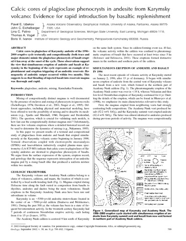
Izbekov Pavel E., Eichelberger John C., Patino Lina C., Vogel Thomas A., Ivanov Boris V. Calcic cores of plagioclase phenocrysts in andesite from Karymsky volcano: Evidence for rapid introduction by basaltic replenishment // Geology. 2002. Vol. 30. № 9. P. 799-802.
Аннотация
Calcic cores in plagioclase of Karymsky andesite of the 1996–2000 eruptive cycle texturally and compositionally (both trace and major elements) mimic the plagioclase phenocrysts of basalt erupted 6 km away at the onset of the cycle. These observations support the view that simultaneous eruption of andesite and basalt at Karymsky in the beginning of the cycle represents an example of replenishment and eruption triggering of an andesitic reservoir. Homogeneity of andesitic output occurred within two months. This suggests to us that blending of injected basalt into reservoir magma was thorough and rapid.
Ji Lingyun, Lu Zhong, Dzurisin Daniel, Senyukov Sergey Pre-eruption deformation caused by dike intrusion beneath Kizimen volcano, Kamchatka, Russia, observed by InSAR // Journal of Volcanology and Geothermal Research. 2013. Vol. 256. P. 87 - 95. https://doi.org/10.1016/j.jvolgeores.2013.02.011
Аннотация
Abstract Interferometric synthetic aperture radar (InSAR) images reveal a pre-eruption deformation signal at Kizimen volcano, Kamchatka, Russia, where an ongoing eruption began in mid-November, 2010. The previous eruption of this basaltic andesite-to-dacite stratovolcano occurred in 1927–1928. InSAR images from both ascending and descending orbital passes of Envisat and ALOS PALSAR satellites show as much as 6 cm of line-of-sight shortening from September 2008 to September 2010 in a broad area centered at Kizimen. About 20 cm of opening of a nearly vertical dike provides an adequate fit to the surface deformation pattern. The model dike is approximately 14 km long, 10 km high, centered 13 km beneath Kizimen, and strikes NE–SW. Time-series analysis of multi-temporal interferograms indicates that (1) intrusion started sometime between late 2008 and July 2009, (2) continued at a nearly constant rate, and (3) resulted in a volume expansion of 3.2 × 10⁷ m3 by September 2010, i.e., about two months before the onset of the 2010 eruption. Earthquakes located above the tip of the dike accompanied the intrusion. Eventually, magma pressure in the dike exceeded the confining strength of the host rock, triggering the 2010 eruption. Our results provide insight into the intrusion process that preceded an explosive eruption at a Pacific Rim stratovolcano following nearly a century of quiescence, and therefore have implications for monitoring and hazards assessment at similar volcanoes elsewhere.
Jiang Guoming, Zhao Dapeng, Zhang Guibin Seismic tomography of the Pacific slab edge under Kamchatka // Tectonophysics. 2009. Vol. 465. № 1–4. P. 190 - 203. https://doi.org/10.1016/j.tecto.2008.11.019
Аннотация
We determine a 3-D P-wave velocity structure of the mantle down to 700 km depth under the Kamchatka peninsula using 678 P-wave arrival times collected from digital seismograms of 75 teleseismic events recorded by 15 portable seismic stations and 1 permanent station in Kamchatka. The subducting Pacific slab is imaged clearly that is visible in the upper mantle and extends below the 660-km discontinuity under southern Kamchatka, while it shortens toward the north and terminates near the Aleutian–Kamchatka junction. Low-velocity anomalies are visible beneath northern Kamchatka and under the junction, which are interpreted as asthenospheric flow. A gap model without remnant slab fragment is proposed to interpret the main feature of high-V anomalies. Combining our tomographic results with other geological and geophysical evidences, we consider that the slab loss may be induced by the friction with surrounding asthenosphere as the Pacific plate rotated clockwise at about 30 Ma ago, and then it was enlarged by the slab-edge pinch-off by the asthenospheric flow and the presence of Meiji seamounts. As a result, the slab loss and the subducted Meiji seamounts have jointly caused the Pacific plate to subduct under Kamchatka with a lower dip angle near the junction, which made the Sheveluch and Klyuchevskoy volcanoes shift westward.
Kalacheva E. G., Kotenko T. A., Voloshina E. V., Erdnieva D. Yu., Melnikov D. V. The Verkhne-Yuriev Thermal Springs: The Evolution of Chemical and Isotope Compositions (1952–2022) in Relation to Active Periods of Ebeko Volcano, Paramushir Island // Journal of Volcanology and Seismology. 2025. Vol. 19. № 1. P. 13-29. 17 p. doi:10.1134/S0742046324700908
Аннотация
This paper describes the chemical composition of the thermal waters discharging on the northwestern slope of the active Ebeko Volcano in the Yuriev River valley. We are using continuous multiyear observations of the evolution of chemical and isotope compositions to estimate the response of volcanic events to the state of the hydrothermal system. It is shown that phreatomagmatic eruptions of the volcano were preceded by a change in the chemical and isotope compositions of thermal waters caused by increased inflow of magmatic volatiles into the system. The springs are observed to show increased concentrations of anion-generating components (chloride, sulfate, and fluorine ions) with concurrent increases in heavier isotopes of oxygen and hydrogen (deuterium) toward “andesitic” water. Recalling that the changes were detected a few months before the eruption, we infer that such geochemical effects can serve as predictive markers when monitoring the state of the volcano.
Kalacheva E.G., Melnikov D.V., Dolgaya A.A., Voloshina E.V. The Formation of the Chemical Composition of Karymsky R. Water As Affected by Hydrothermal and Volcanic Activity in Kamchatka // Journal of Volcanology and Seismology. 2024. Vol. 18. № 2. P. 132-148. 17 p. doi:10.1134/S0742046324700490
Аннотация
This paper examines the Karymsky Volcanic Center to estimate how much volcanic and hydrothermal activity affects the chemical composition of river water. We evaluate the volumes of major and trace elements coming to the Pacific Ocean via the Karymsky River. We assess the quality of river water in compliance with the regulations for potable water, water used for household work, and in fisheries. It is shown that the formation of ion load of the river water mostly occurs by inflow of thermal waters, as well as due to water-soluble complexes of ashes discharged by Karymsky Volcano and coming to the catchment area of the river. The annual volume of dissolved material transported by the river to the Kronotsky Bay of the Pacific Ocean amounts to more than 90 kilotons.
Kalacheva Elena, Taran Yuri, Kotenko Tatiana Geochemistry and solute fluxes of volcano-hydrothermal systems of Shiashkotan, Kuril Islands // Journal of Volcanology and Geothermal Research. 2015. Vol. 296. P. 40-54. doi:10.1016/j.jvolgeores.2015.03.010
Аннотация
Shiashkotan Island belongs to the Northern Kuril island arc and consists of two joined volcanoes, Sinarka and
Kuntomintar, with about 18 km of distance between the summits. Both volcanoes are active, with historic
eruptions, and both emit fumarolic gases. Sinarka volcano is degassing through the extrusive domewith inaccessible
strong and hot (N400 °C) fumaroles. A large fumarolic field of the Kuntomintar volcano situated in a wide
eroded caldera-like crater hosts many fumarolic vents with temperatures from boiling point to 480 °C. Both
volcanoes are characterized by intense hydrothermal activity discharging acid SO4-Cl waters, which are drained
to the Sea of Okhotsk by streams. At least 4 groups of near-neutral Na-Mg-Ca-Cl-SO4 springs with temperatures in
the range of 50–80 °C are located at the sea level,within tide zones and discharge slightly altered diluted seawater.
Volcanic gas of Kuntomintar as well as all types of hydrothermal manifestations of both volcanoes were collected
and analyzed for major and trace elements and water isotopes. Volcanic gases are typical for arc volcanoes
with 3He/4He corrected for air contamination up to 6.4 Ra (Ra=1.4 ×10⁻⁶, the air ratio) and δ13C (CO2) within
−10‰to−8‰VPDB. Using a saturation indices approach it is shown that acid volcanic waters are formed at a
shallow level, whereas waters of the coastal springs are partially equilibrated with rocks at ~180 °C. Trace
element distribution and concentrations and the total REE depend on the water type, acidity and Al+Fe concentration.
The REE pattern for acidic waters is unusual but similar to that found in some acidic crater lake waters.
The total hydrothermal discharge of Cl and S from the island associated with volcanic activity is estimated at
ca. 20 t/d and 40 t/d, respectively, based on the measurements of flow rates of the draining streams and
their chemistry. The chemical erosion of the island by surface and thermal waters is estimated at 27 and 140
ton/km2/year, respectively, which is 2–3 times lower than chemical erosion of tropical volcanic islands.
Kalacheva Elena, Taran Yuri, Kotenko Tatiana, Hattori Keiko, Kotenko Leonid, Solis-Pichardo Gabriela Volcano–hydrothermal system of Ebeko volcano, Paramushir, Kuril Islands: Geochemistry and solute fluxes of magmatic chlorine and sulfur // Journal of Volcanology and Geothermal Research. 2016. Vol. 310. P. 118-131. doi:10.1016/j.jvolgeores.2015.11.006
Аннотация
Ebeko volcano at the northern part of Paramushir Island in the Kuril island arc produces frequent phreatic eruptions and relatively strong fumarolic activity at the summit area ~ 1000 m above sea level (asl). The fumaroles are characterized by low-temperature, HCl- and S-rich gas and numerous hyper-acid pools (pH < 1) without drains. At ~ 550 m asl, in the Yurieva stream canyon, many hot (up to 87 °C) springs discharge ultra-acidic (pH 1–2) SO4–Cl water into the stream and finally into the Sea of Okhotsk. During quiescent stages of degassing, these fumaroles emit 1000–2000 t/d of water vapor, < 20 t/d of SO2 and < 5 t/d of HCl. The measurement of acidic hot Yurieva springs shows that the flux of Cl and S, 60–80 t/d each, is independent on the volcanic activity in the last two decades. Such high flux of Cl is among the highest ever measured in a volcano–hydrothermal system. Oxygen and hydrogen isotopic composition of water and Cl concentration for Yurieva springs show an excellent positive correlation, indicating a mixing between meteoric water and magmatic vapor. In contrast, volcanic gas condensates of Ebeko fumaroles do not show a simple mixing trend but rather a complicated data suggesting evaporation of the acidic brine. Temperatures calculated from gas compositions and isotope data are similar, ranging from 150 to 250 °C, which is consistent with the presence of a liquid aquifer below the Ebeko fumarolic fields. Saturation indices of non-silicate minerals suggest temperatures ranging from 150 to 200 °C for Yurieva springs. Trace elements (including REE) and Sr isotope composition suggest congruent dissolution of the Ebeko volcanic rocks by acidic waters. Waters of Yurieva springs and waters of the summit thermal fields (including volcanic gas condensates) are different in Cl/SO4 ratios and isotopic compositions, suggesting complicated boiling–condensation–mixing processes.
Kardanova O. F., Dubrovskaya I. K., Murav’ev Ya. D. Thermal anomalies on Savich Cone, Kikhpinych Volcano, Kamchatka: IR surveys and land-based observations for 30 years (1982 through 2012) // Journal of Volcanology and Seismology. 2015. Vol. 9. № 6. P. 368-377. doi:10.1134/S0742046315060032
Karpov G.A., Miller Yu.M., Zavarzin G.A. The composition of air and spontaneous gases in the Death Valley in Kamchatka // Volcanology and Seismology. 1987. № 5. P. 481-485.