Melekestsev I.V., Braitseva O.A., Sulerzhitskii L.D., Ogorodov N.V., Kozhemiaka N.N., Egorova I.A., Lupikina E.G. Age of Volcanoes in the Kurille-Kamchatka Zone // International Association of Volcanology and Chemistry of the Earth`s Interior. Sumposium on Volcanoes &Their Roots. Oxford: 1969. P. 138-139.
Melekestsev I.V., Dirksen O.V., Girina O.A. A giant landslide-explosion circue and debris avalanche at Bakening volcano, Kamchatka // Volcanology and Seismology. 1999. Vol. 20. № 3. P. 265-279.
Аннотация
This study revealed that the giant cirque of Bakening Volcano had been produced by its eruption ca. 8000-8500 carbon-14 year ago. The eruption is supposed to have been heralded by a large earthquake (M > 7) resulting in the collapse and slide of the SE sector of the cone. The landslide unroofed the hydrothermal system and triggered an explosion which was followed by an ash-and-block pyroclastic flow. A rockslide avalanche rolled down into the valley of the Srednyaya Avacha River and travelled as far as 10-11 km along it. The avalanche deposited its debris material over an area of 18-20 km2 measuring 0.4-0.5 km3 in volume. These deposits dammed the river, produced two lakes (Bezymyannoe and Verkhneavacha), and gave birth to a large lahar which traveled along the valley much farther.
Melekestsev I.V., Dvigalo V.N., Kirianov V.Yu., Kurbatov A.V., Nesmachnyi I.A. Ebeko volcano, Kuril Islands: eruptive history and potential volcanic hazards. Part I // Volcanology and Seismology. 1994. Vol. 15. № 3. P. 339-354.
Аннотация
The eruptive history of Ebeko Volcano is described since its origin about 2400 years ago until the beginning of the 17th century. Six stages of increased activity each lasting 200-300 years were separated by repose periods of the same duration. The eruption of juvenile material (lava and pyroclastics) took place at the first stage only (420-200 B.C.). All eruptions that followed were phreatic events of varying vigor. It is shown that, except for the first eruptive stage, the main volcanic hazard for the Ebeko area and the town of Severo-Kurilsk near by comes from large lahars and tephra fallout. -from Journal summary
Melekestsev I.V., Dvigalo V.N., Kirianov V.Yu., Kurbatov A.V., Nesmachnyi I.A. Ebeko volcano, Kuril Islands: eruptive history and potential volcanic hazards. Part II // Volcanology and Seismology. 1994. Vol. 15. № 4. P. 411-430.
Аннотация
Consequences of the Ebeko eruptions in the 17th-20th centuries have been reconstructed, using historical records, tephrochronological study, and air photographs. It is shown that all eruptions were phreatic and phreatomagmatic with a heat source of a strongly heated dike-sill complex of more than 1 km3 volume. It is supposed that the main potential hazard for Severo-Kurilsk city and adjacent area may be connected with large-volume lahar flows along the Kuzminka and Matrosskaya Rivers, which are sourced on Ebeko Volcano. Lesser hazard is expected from ashfalls of this and other volcanoes of the north Kurils and south Kamchatka. -from Journal summary
Melekestsev I.V., Kartasheva E.V., Kirsanova T.P., Kuzmina A.A. Water Contaminated Fresh Tephra as a Natural Hazard Factor: the 2008-2009 Eruption of Koryakskii Volcano, Kamchatka // Journal of Volcanology and Seismology. 2011. Vol. 5. № 1. P. 17-30. doi: 10.1134/S0742046311010064.
Аннотация
Abstract-This study is the first to show, using data from the eruption of Koryakskii Volcano, Kamchatka that began in December 2008 and continued through 2009 that the water in permanent and temporary streams that start on the slopes of the volcanic cone and in temporary lakes when contaminated with fresh tephra is a specific hazard factor related to long-continued hydrothemial-phreatic eruptions on that volcano. This water is characterized by increased acidity (pH 4.1-4.35) and large amounts (up to 50-100 cm /liter) of solid suspension and is unfit for drinking and irrigation. When combined with tephra, it probably produced mass destruction of a number of animals who lived on the slopes and at the base of the volcano. The water contaminated with tephra is an important component of the atmospheric mud tlows occurring on Koryakskii Volcano; for several future years it will be a potential source for enhancing the acidity of ground water in the volcanic edifice.
Melekestsev I.V., Kirianov V.Yu. When will Avacha Volcano in Kamchatka erupt? // Volcanology and Seismology. 1988. Vol. 6. № 6. P. 943-952.
Melekestsev I.V., Sulerzhitskiy L.D., Bazanova L.I., Braitseva O.A., Florenskaya N.I. Holocene catastrophic lahars at Avacha and Koryakskiy volcanoes in Kamchatka // Volcanology and Seismology. 1996. Vol. 17. № 4-5. P. 561-570.
Аннотация
Remnants of five catastrophic lahars have been discovered, described, and dated by the carbon-14 method. They occurred during eruptions of Avacha (violent explosions with voluminous juvenile pyroclastics) and Koryakskiy (large fissure lava flows): 3500 to 3200 14C years ago or 1900-1500 years B.C. These lahars were much higher in vigor, hazard, and effect on the environment than the lahars generated by the historic eruptions of these volcanoes. -from Journal summary
Melekestsev Ivan V., Ponomareva Vera V., Volynets Oleg N. Kizimen volcano, Kamchatka — A future Mount St. Helens? // Journal of Volcanology and Geothermal Research. 1995. Vol. 65. № 3-4. P. 205-226.
Аннотация
We studied the tectonic setting, morphology, geologic structure, history of eruptive activity and evolution of the composition of the erupted material of Kizimen volcano, Kamchatka, from the moment of its origination 11–12 thousand years ago to the present time. Four cycles, each 2–3.5 thousand years long, were distinguished that characterize the activity of the volcano. All of the largest eruptions were dated, and their parameters determined. We also estimated the volume and the mass of the erupted products, the volcanic intensity of eruption of material during periods of high activity, and the amount of material the volcano ejected at different stages of its formation. It has been shown that the evolution of the composition of the rocks erupted (from dacite to basaltic andesite) takes place as a result of mixing of dacitic and basaltic magma. It is suggested that future eruptions that may take place at Kizimen may be similar to those at Bandai (1888) and Mount St. Helens (1980) volcanoes.
Melnik O., Lyakhovsky V., Shapiro Nikolay M., Galina N., Bergal-Kuvikas Olga Deep long period volcanic earthquakes generated by degassing of volatile-rich basaltic magmas // Nature Communications. 2020. Vol. 11. № 3918. doi: 10.1038/s41467-020-17759-4.
Аннотация
Deep long-period (DLP) earthquakes observed beneath active volcanoes are sometimes considered as precursors to eruptions. Their origin remains, however, unclear. Here, we present a possible DLP generating mechanism related to the rapid growth of gas bubbles in response to the slow decompression of over-saturated magma. For certain values of the gas and bubble content, the elastic deformation of surrounding rocks forced by the expanding bubbly magma can be fast enough to generate seismic waves. We show that amplitudes and frequencies of DLP earthquakes observed beneath the Klyuchevskoy volcano (Kamchatka, Russia) can be predicted by our model when considering pressure changes of ~107 Pa in a volume of ~103–104 m3 and realistic magma compositions. Our results show importance of the deep degassing in the generation of volcanic seismicity and suggest that the DLP swarms beneath active volcanoes might be related to the pulses of volatile-rich basaltic magmas rising from the mantle.
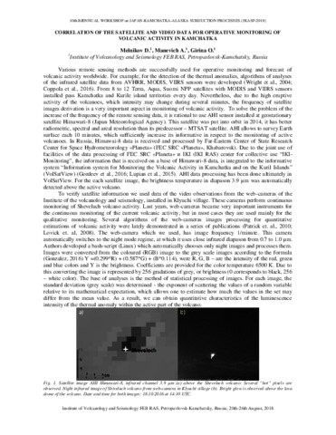
Melnikov D.V., Manevich A.G., Girina O.A. Correlation of the satellite and video data for operative monitoring of volcanic activity in Kamchatka // JKASP-2018. Petropavlovsk-Kamchatsky: IVS FEB RAS. 2018.