|
Записей: 130
Gusev A.A., Ponomareva V.V., Braitseva O.A., Melekestsev I.V., Sulerzhitsky L.D. Great explosive eruptions on Kamchatka during the last 10,000 years: Self-similar irregularity of the output of volcanic products // Journal of Geophysical Research. 2003. Vol. 108. № B2. doi:10.1029/2001JB000312
Аннотация
Temporal irregularity of the output of volcanic material is studied for the sequence of large (V ≥ 0.5 km3, N = 29) explosive eruptions on Kamchatka during the last 10,000 years. Informally, volcanic productivity looks episodic, and dates of eruptions cluster. To investigate the probable self-similar clustering behavior of eruption times, we determine correlation dimension Dc. For intervals between events 800 and 10,000 years, Dc ≈ 1 (no self-similar clustering). However, for shorter delays, Dc = 0.71, and the significance level for the hypothesis Dc < 1 is 2.5%. For the temporal structure of the output of volcanic products (i.e., for the sequence of variable-weight points), a self-similar “episodic” behavior holds over the entire range of delays 100–10,000 years, with Dc = 0.67 (Dc < 1 at 3.4% significance). This behavior is produced partly by the mentioned common clustering of event dates, and partly by another specific property of the event sequence, that we call “order clustering”. This kind of clustering is a property of a time-ordered list of eruptions, and is manifested as the tendency of the largest eruptions (as opposed to smaller ones) to be close neighbors in this list. Another statistical technique, of “rescaled range” (R/S), confirms these results. Similar but weaker-expressed behavior was also found for two other data sets: historical Kamchatka eruptions and acid layers in Greenland ice column. The episodic multiscaled mode of the output of volcanic material may be a characteristic property of a sequence of eruptions in an island arc, with important consequences for climate forcing by volcanic aerosol, and volcanic hazard.


|
Kirsanov I.T. Acid volcanism and thermal manifestations in the area of Mutnovsky and Gorely volcanoes (Southern Kamchatka) // Bulletin Volcanologique. 1967. Vol. 30. Vol. 1. P. 139-151. 13 p. doi:10.1007/BF02597664
|
Kiryukhin A.V., Polyakov A.Y., Voronin P.O., Zhuravlev N.B., Usacheva O.O., Solomatin A.V., Kiryukhin P.A. Magma fracking and production reservoirs beneath and adjacent to Mutnovsky volcano based on seismic data and hydrothermal activity // Geothermics. 2022. Vol. 105. № 102474. 1 p. doi:10.1016/j.geothermics.2022.102474
Аннотация
Mutnovsky geothermal area in Kamchatka, Russia where 62 MWe GeoPP installed - is a source of geothermal electricity supply, as well as a hazard volcanic area. We used local seismicity micro-earthquakes (MEQ’s) data from 2009 to 2021 to define seismogenic faults beneath and adjacent to Mutnovsky volcano, which interpreted as magma injections in form of dykes and sills. Magma fracking beneath Mutnovsky volcano pointed on shear mode low angle dykes in northeast sector and opening mode geomechanical conditions at -3000 m, where sills in area of 62 km2 are suggested to be formed. Low angle dykes injections were reproduced by hydromechanical simulation using CFRAC, modeling results matches with MEQ’s statistics observed.
Mutnovsky GeoPP steam collection system shows sensitivity to non-condensable gasses (NCG) content (partial gas pressure) variations (2019—2020), that is used as indicator of magmatic gasses recharge via magma fracking volcano system to production geothermal reservoir. Partial gas pressure measured at GeoPP condenser unit. Magma injections associated with NCG (CO2) release in production reservoirs seems to be synchronize with partial NCG pressure excursions at GeoPP condenser. Some signs of magma fracking events were also revealed using discreet observations (2016–2021) on a blowing wells on a foothills of Mutnovsky volcano. Magma fracking beneath Mutnovsky volcano is associate with small and medium hydrothermal explosions and landslide (2009–2021). Magma fracking distributions pointed on a new potentially production geothermal reservoir beneath northeast foothills of Mutnovsky volcano (depth range from -4000 to -2000 m, accessible area of 30 km2).

|
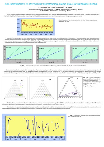
Maximov A.P., Firstov P.P., Chernev I.I., Shapar V.N. Gas composition in Mutnovsky geothermal field: Role of meteoric water // 11th Gas Workshop. 1-10 September 2011, Kamchatka, Russia. 2011. P. 31.
|
Melnikov D.V., Ushakov S.V., Galle B. Estimation of the sulfur dioxide emission by Kamchatka volcanoes using differential optical absorption spectroscopy // 8-th Biennial Workshop on Japan-Kamchatka-Alaska Subduction Processes, JKASP 2014. 22-26 September, 2014, Sapporo, Japan. 2014.
Аннотация
During the 2012-2013 we have measured SO2 on Kamchatka volcanoes (Gorely, Mutnovsky, Kizimen, Tolbachik, Karymsky, Avachinsky) using DOAS (differential optical absorption spectroscopy). Mobile-DOAS, on a base of USB2000+, has been used as an instrument. The goal of this work was to estimate SO2 emission by Kamchatka volcanoes with the different types of activity. Mutnovsky and Avachinsky during the measurements period passively degassed with SO2 emission ~ 480 t/d and 210 t/d, respectively. Gorely volcano was very active, with intensive vapor-gas activity with gas discharge rate 800-1200 t/d. During the measurements at Karymsky volcano there were relatively weak explosive events (ash plum rose up to 0.5 km above the crater) with 5-10 minutes periodicity. For this time, SO2 discharge rate was ~350-400 t/d. Due to the remoteness and difficulties for accessibility of Kizimen volcano, the measurements were done only once – on October 15th, 2012. 5 traverses have been done above the gas plume. SO2 emission was ~ 700 t/d. On Tolbachik fissure eruption we have measured SO2 emission repeatedly from January until August 2013. The intensive effusion of the lava flows (basaltic andesite by composition) and frequent explosions in the crater of the cinder cone were characteristic features of this eruption. The measured gas emission was from ~1500-2200 t/d in January until 600-800 t/d in August 2013. All measurements were made not permanently, but to the extent possible. Therefore, it is difficult to make detailed conclusions on the SO2 emission on these volcanoes. Nevertheless, this research may become a starting point for the development of the system of the constant monitoring of volcanic gases emission by the active volcanoes of Kamchatka.
Estimation of the sulfur dioxide emission by Kamchatka volcanoes using differential optical absorption spectroscopy.

|
Ozerova N., Ozerov A. Atmochemical halos of mercury (Hg) within the area of active volcanic edifices in Kamchatka // IAVCEI 2008 - General Assembly, Reykjavik, Iceland. Abstracts. 2008. P. 7.
|
Ozerova N., Ozerov A. Mercury (Hg) in the near-ground atmosphere of active volcanic edifices in Kamchatka // 33rd International Geological Congress. Oslo, Norway. Abstracts. 2008.
|
Ozerova N.A., Ozerov A.Yu. Mercury in vapor-gas fumarole jets and products of their sedimentation at the Mutnovsky volcano // Commission on the chemistry of volcanic gases (CCVG) - IAVCEI. 11th Gas Workshop, Kamchatka, Russia. 1-10 September 2011. 2011. P. 36.
|
Ponomareva V.V., Churikova T., Melekestsev I.V., Braitseva O.A., Pevzner M., Sulerzhitskii L. Late Pleistocene-Holocene Volcanism on the Kamchatka Peninsula, Northwest Pacific Region / Volcanism and Subduction: The Kamchatka Region. Washington, D. C.: American Geophysical Union. 2007. Vol. 172. P. 165-198. https://doi.org/10.1029/172GM15
Аннотация
Late Pleistocene-Holocene volcanism in Kamchatka results from the subduction of the
Pacific Plate under the peninsula and forms three volcanic belts arranged in en echelon manner
from southeast to northwest. The cross-arc extent of recent volcanism exceeds 250 km and
is one of the widest worldwide. All the belts are dominated by mafic rocks. Eruptives with
SiO2>57% constitute ~25% of the most productive Central Kamchatka Depression belt and
~30% of the Eastern volcanic front, but <10% of the least productive Sredinny Range belt.
All the Kamchatka volcanic rocks exhibit typical arc-type signatures and are represented
by basalt-rhyolite series differing in alkalis. Typical Kamchatka arc basalts display a strong
increase in LILE, LREE and HFSE from the front to the back-arc. La/Yb and Nb/Zr increase
from the arc front to the back arc while B/Li and As, Sb, B, Cl and S concentrations decrease.
The initial mantle source below Kamchatka ranges from N-MORB-like in the volcanic front
and Central Kamchatka Depression to more enriched in the back arc. Rocks from the Central
Kamchatka Depression range in 87Sr/86Sr ratios from 0.70334 to 0.70366, but have almost
constant Nd isotopic ratios (143Nd/144Nd 0.51307–0.51312). This correlates with the highest
U/Th ratios in these rocks and suggest the highest fluid-flux in the source region.
Holocene large eruptions and eruptive histories of individual Holocene volcanoes have been
studied with the help of tephrochronology and 14C dating that permits analysis of time-space
patterns of volcanic activity, evolution of the erupted products, and volcanic hazards.

|
Ponomareva Vera V., Melekestsev Ivan V., Dirksen Oleg V. Sector collapses and large landslides on Late Pleistocene–Holocene volcanoes in Kamchatka, Russia // Journal of Volcanology and Geothermal Research. 2006. Vol. 158. № 1-2. P. 117-138. doi:10.1016/j.jvolgeores.2006.04.016
Аннотация
On Kamchatka, detailed geologic and geomorphologic mapping of young volcanic terrains and observations on historical eruptions reveal that landslides of various scales, from small (0.001 km3) to catastrophic (up to 20–30 km3), are widespread. Moreover, these processes are among the most effective and most rapid geomorphic agents. Of 30 recently active Kamchatka volcanoes, at least 18 have experienced sector collapses, some of them repetitively. The largest sector collapses identified so far on Kamchatka volcanoes, with volumes of 20–30 km3 of resulting debris-avalanche deposits, occurred at Shiveluch and Avachinsky volcanoes in the Late Pleistocene. During the last 10,000 yr the most voluminous sector collapses have occurred on extinct Kamen' (4–6 km3) and active Kambalny (5–10 km3) volcanoes. The largest number of repetitive debris avalanches (> 10 during just the Holocene) has occurred at Shiveluch volcano. Landslides from the volcanoes cut by ring-faults of the large collapse calderas were ubiquitous. Large failures have happened on both mafic and silicic volcanoes, mostly related to volcanic activity. Orientation of collapse craters is controlled by local tectonic stress fields rather than regional fault systems.
Specific features of some debris avalanche deposits are toreva blocks — huge almost intact fragments of volcanic edifices involved in the failure; some have been erroneously mapped as individual volcanoes. One of the largest toreva blocks is Mt. Monastyr' — a ∼ 2 km3 piece of Avachinsky Somma involved in a major sector collapse 30–40 ka BP.
Long-term forecast of sector collapses on Kliuchevskoi, Koriaksky, Young Cone of Avachinsky and some other volcanoes highlights the importance of closer studies of their structure and stability.

|
|