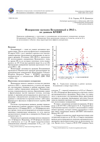
Извержение вулкана Безымянный в 2012 г. по данным KVERT (2012)
Гирина О.А., Демянчук Ю.В. Извержение вулкана Безымянный в 2012 г. по данным KVERT // Вулканизм и связанные с ним процессы. Материалы региональной научной конференции, посвящённой Дню вулканолога (к 50-летию ИВиС ДВО РАН). Петропавловск-Камчатский, 29 - 30 марта 2012 г. Петропавловск-Камчатский: ИВиС ДВО РАН. 2012. С. 24-27.
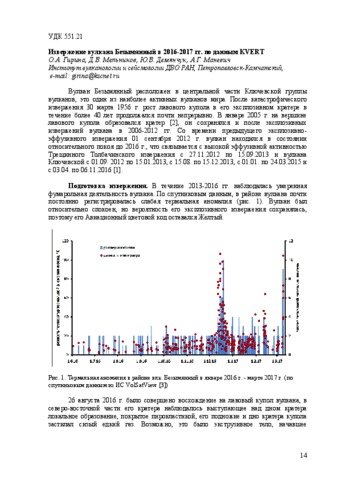
Извержение вулкана Безымянный в 2016-2017 гг. по данным KVERT (2017)
Гирина О.А., Мельников Д.В., Демянчук Ю.В., Маневич А.Г. Извержение вулкана Безымянный в 2016-2017 гг. по данным KVERT // Материалы XX региональной научной конференции «Вулканизм и связанные с ним процессы», посвящённой Дню вулканолога, 30-31 марта 2017 г. Петропавловск-Камчатский: ИВиС ДВО РАН. 2017. С. 14-17.
Извержение вулкана Безымянный в июне 1986 г. (1991)
Максимов А.П., Фирстов П.П., Гирина О.А., Малышев А.И. Извержение вулкана Безымянный в июне 1986 г. // Вулканология и сейсмология. 1991. № 1. С. 3-20.
Annotation
The study presents the results of field observations, granulometric and seismoacustic investigations related to a small eruption of the Bezymianny volcano. The characteristic features of the eruption illustrated in the scheme are interpreted to be due to the deeper position in the volcanic channel of the zone enriched in the gas phase.
Кирсанов И.Т. Извержение вулкана Горелого в 1980 г. // Вулканология и сейсмология. 1981. № 1. С. 70-74.
Извержение вулкана Горелый в 1985 г. (1988)
Иванов Б.В., Дрознин В.А., Вакин Е.А., Иванов В.В., Овсянников А.А., Разина А.А. Извержение вулкана Горелый в 1985 г. // Вулканология и сейсмология. 1988. № 4. С. 93-98.
Извержение вулкана Жупановский (Природный парк "Налычево") в 2013-2015 гг. (2017)
Гирина О.А., Ненашева Е.М. Извержение вулкана Жупановский (Природный парк "Налычево") в 2013-2015 гг. // Особо охраняемые природные территории Камчатского края: опыт работы, проблемы управления и перспективы развития: доклады Второй региональной научно-практической конференции. Петропавловск-Камчатский: Камчатпресс. 2017. С. 89-93.
Извержение вулкана Заварицкого на острове Симушир осенью 1957 г. (1960)
Мархинин Е.К. Извержение вулкана Заварицкого на острове Симушир осенью 1957 г. // Бюллетень вулканологической станции. 1960. № 29. С. 7-14.
Абдурахманов А.И., Злобин Т.К., Мархинин Е.К., Тараканов Р.З. Извержение вулкана Иван Грозный в 1989 г. // Вулканология и сейсмология. 1990. № 4. С. 3-9.
Annotation
Recent activity of the volcano is associated with its multiaction central effusion dome. The N—N—E top of this dome has a crater of the specific shape with a radial fissure 250—270 m long and 15—70 m wide. Small phreatic eruptions were noted in 1951, 1968, 1970, and 1973. The eruption of 1989 started on May 3. Explosions produced ash-gas cloud which rose to a height of 1,5 km on May 8. The very first explosions were followed by formation of a new fissure on the northern flank of the volcano, its length being about 70 m. The eruption was preceded by earthquakes which occurred beneath the volcano and were oriented across the strike of the Kuril Island arc. These earthquakes can be subdivided into two groups with focal depths close to 30 km and 60— 80 km. The layer between the depths from 30 to 55—60 km seems to be aseismic indicating that in the depth range of 30—60 km beneath the volcano a magma chamber can be present. It is suggested that current intensified activity of the volcano has been caused by tectonic movements associated with transverse faulting. A sort-term forecast of the volcano activity is presented.
Гирина О.А., Мельников Д.В., Маневич А.Г., Нуждаев А.А. Извержение вулкана Камбальный в 2017 г. // Современные проблемы дистанционного зондирования Земли из космоса. 2017. Т. 14. № 2. С. 263-267. https://doi.org/10.21046/2070-7401-2017-14-2-263-267.
Annotation
The first historical eruption of Kambalny volcano began on March 24, 2017 with a powerful ash emission up to 6 km above sea level from the pre-summit crater. According to tephrochronology, it is assumed that the strong eruptions of the volcano occurred 200 (?) and 600 years ago. The maximum intensity of ash emission occurred on 25–26 March: uninterrupted plume laden with ash particles spread over several thousand kilometers, changing the direction of propagation from the volcano from the south-west to the south and south-east. On 27–29 March, the ash plume extended to the west, on 30 March – to the southeast, and on April 02 – to the east of the volcano. On March 31 and April 01, the volcano was relatively quiet. The resumption of the volcano activity after two days of rest was expressed in powerful ash emissions up to 7 km above sea level. A small ash plume was noted on 04 April, and powerful ash emissions up to 7 km above sea level occurred on 09 April. The area of ashes on the land was 1300 km2, the total area covered by ash falls, for example, on 25 March, – 650 thousand km2. To observe the Kambalny volcano eruption we used mainly satellite images of medium resolution available in the information system "Monitoring activity of volcanoes of Kamchatka and Kurile Islands" (VolSatView).