Kugaenko Yulia, Volynets Anna O. Magmatic plumbing systems of the monogenetic volcanic fields: A case study of Tolbachinsky Dol, Kamchatka // Journal of Volcanology and Geothermal Research. 2018. doi:10.1016/j.jvolgeores.2018.03.015.
Annotation
Clusters of small-volume volcanoes that individually may be defined as monogenetic, but have interlinked and
interconnected plumbing systems, are used to be categorized as monogenetic volcanic fields (MVF).We argue
that such volcanic clusters should be distinguished as separate type of volcanism, intermediate between monogenetic and polygenetic. The magma plumbing system structure of the MVF (its complexity and polymagmatic
character) is the key argument for the potential separation of themin a classification. To avoid confusion caused by geneticmeaning of the used words we suggest using a term “areal volcanism” or “areal volcanic fields” (AVF instead of MVF) as defining this special type of volcanic activity. Herewe provide a reviewof themain characteristic features of one of the largest Holocene AVF, which is active now – the Tolbachik field of cinder cones in the southern part of Klyuchevskaya volcano group (Kamchatka), known in the literature as Tolbachinsky Dol. This paper is focused on the research of magma plumbing system. We consider structural,morphological, geological, geochemical and petrological data on the erupted basalts and their genesis. Specially planned seismic experiments made in 2010–2015 (seismic tomography and microseismic sounding) allowedmodeling of the principal elements of the magma plumbing system of Tolbachik AVF. Analysis of the investigations made in this area shows that Tolbachik AVF has a complex, dynamic, variable magmatic feeding system, which can be visualized as a superposition of subvertical and sublateral magma conduits. The contrast composition of the erupted rocks is caused by their different, although genetically connected, magma sources and mixing processes. One of the long-lived eruptive centers of Tolbachik AVF is Plosky Tolbachik stratovolcano, which lost its independent activity and was captured by Tolbachik AVF in Holocene. The AVF formed rejuvenated volcanism using the feeding system of the stratovolcano like an “old anthill”. The magma plumbing system characteristics of Tolbachinsky Dol strongly support the idea of separation of AVF from monogenetic volcanism type in the classification.
Manevich A.G., Girina O.A., Melnikov D.V., Nuzhdaev A.A. 2016-2017 explosive eruptions of Kamchatka volcanoes based on KVERT data // JKASP-2018. Petropavlovsk-Kamchatsky: IVS FEB RAS. 2018.
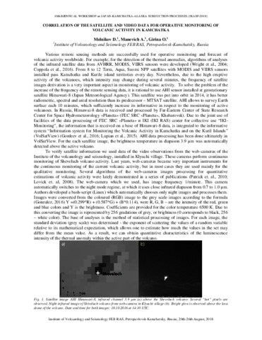
Melnikov D.V., Manevich A.G., Girina O.A. Correlation of the satellite and video data for operative monitoring of volcanic activity in Kamchatka // JKASP-2018. Petropavlovsk-Kamchatsky: IVS FEB RAS. 2018.
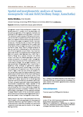
Melnikov D.V., Volynets Anna Spatial and morphometric analyses of Anaun monogenetic volcanic field (Sredinny Range, Kamchatka) // 7th International Maar Conference, Olot, Catalonia, Spain. 2018. P. 61
Annotation
Monogenetic volcanic fields are frequently located in the faulted area and in clusters which are associated with the particular geometry of the magmatic chambers and structures of the magma plumbing system in the crust. The method of cluster analyses of the spatial distribution and morphometric characteristics of the cinder cones was used in our research of the conditions of origin and evolution of one of the largest monogenetic fields in Kamchat-ka back-arc-the Anaunsky Dol, or Anaun MVF. Kamchat-ka subduction system is located at the northwestern part of the Pacific at the convergent boundary of the Okhotsk and Pacific plates. Today, Sredinny Range represents its back-arc part and is characterized by the wide distribution of the monogenetic volcanic fields: it has more than 1000 cinder cones, which deposits cover the area of about 8500 km2 (Laverov, 2005; Ogorodov et al., 1972) (Fig. 1). Sredinny Range has a complex structure with several volcanic provinces with different geological history and variable composition of products. Anaun monogenetic volcanic field occupies one of the lowest sections of the whole Sredinny Range. The youngest volcanism in this area (according to the geological map, it was formed in Quaternary times, although our geochemical research and isotopic dating shows its earlier age) is confined to the lowered block of basement rocks. Shield volcanoes, volcanic ridges, cinder and lava cones are located on a low-laying volcanic dale. We made an attempt to make a spatial analysis of distribution of the volcanic edifices and to quantitatively estimate the structural control of the magma plumbing channels. Based on a digital relief model (DEM SRTM, spatial resolution 30 m) we distinguished more than 100 morphometrically expressed cinder cones. For them, using semi-automatic mode, we estimated the morphometric characteristics: height, diameter of the basement, height/basement ratio, angle of the slope, volume of the edifice. With time, cinder cones change their shape due to the erosion processes. Therefore, finally the edifice height is decreased while the basement diameter increased. Determination of the morphometric parameters allowed us to compose a relative age scale for the cinder cones located in Anaun monogenetic volcanic field. Spatial analysis has shown that cones tend to form series of clusters, which are associated with the systems of lineaments. Statistically significant patterns in the cinder cones distribution were then compared with the strike of lineaments to estimate possible location of the magma feeding channels.
Romanova I.M., Girina O.A. Spatial Data Infrastructure for information support of volcanological investigations // 10th Biennual workshop on Japan-Kamchatka-Alaska subduction processes (JKASP-2018). Petropavlovsk-Kamchatsky, Russia, August 20-26. // 10th Biennual workshop on Japan-Kamchatka-Alaska subduction processes (JKASP-2018). Petropavlovsk-Kamchatsky: IVS FEB RAS. 2018. P. 193-195.
Taran Yuri, Zelenski Mikhail, Chaplygin Ilya, Malik Natalia, Campion Robin, Inguaggiato Salvatore, Pokrovsky Boris, Kalacheva Elena, Melnikov Dmitry, Kazahaya Ryunosuke, Fischer Tobias Gas Emissions From Volcanoes of the Kuril Island Arc (NW Pacific): Geochemistry and Fluxes // Geochemistry, Geophysics, Geosystems. 2018. Vol. 19. Vol. 6. P. 1859-1880. doi: 10.1029/2018GC007477.
Annotation
The Kuril Island arc extending for about 1,200 km from Kamchatka Peninsula to Hokkaido Island is a typical active subduction zone with ∼40 historically active subaerial volcanoes, some of which are persistently degassing. Seven Kurilian volcanoes (Ebeko, Sinarka, Kuntomintar, Chirinkotan, Pallas, Berg, and Kudryavy) on six islands (Paramushir, Shiashkotan, Chirinkotan, Ketoy, Urup, and Iturup) emit into the atmosphere > 90% of the total fumarolic gas of the arc. During the field campaigns in 2015–2017 direct sampling of fumaroles, MultiGas measurements of the fumarolic plumes and DOAS remote determinations of the SO2 flux were conducted on these volcanoes. Maximal temperatures of the fumaroles in 2015–2016 were 510°C (Ebeko), 440°C (Sinarka), 260°C (Kuntomintar), 720°C (Pallas), and 820°C (Kudryavy). The total SO2 flux (in metric tons per day) from fumarolic fields of the studied volcanoes was measured as ∼1,800 ± 300 t/d, and the CO2 flux is estimated as 1,250 ± 400 t/d. Geochemical characteristics of the sampled gases include δD and δ18O of fumarolic condensates, δ13C of CO2, δ34S of the total sulfur, ratios 3He/4He and 40Ar/36Ar, concentrations of the major gas species, and trace elements in the volcanic gas condensates. The mole ratios C/S are generally <1. All volcanoes of the arc, except the southernmost Mendeleev and Golovnin volcanoes on Kunashir Island, emit gases with 3He/4He values of >7RA (where RA is the atmospheric 3He/4He). The highest 3He/4He ratios of 8.3RA were measured in fumaroles of the Pallas volcano (Ketoy Island) in the middle of the arc.
Аникин Л.П., Силаев В.И., Чубаров В.М., Петровский В. А., Вергасова Л.П., Карпов Г.А., Сокоренко А.В., Овсянников А.А., Максимов А.П. Алмаз и другие акцессорные минералы в продуктах извержения 2008—2009 гг. Корякского вулкана (Камчатка) // Вестник ИГ Коми НЦ УрО РАН. 2018. № 2. С. 18-27. doi: 10.19110/2221-1381-2018-2-18-27.
Annotation
The paper provides new data related to the accessory minerals found in ashes from phreatic eruption of Klyuchevskoy volcano in 2008—2009. We characterized form of extraction, composition and specific features of garnet, corundum, deltalumine, muassonite, sulfide thallium, native metal and carbon phases including micro-diamond, and also likely abiogenic condensed organic compound. A feature of the Koryak diamonds is a very small size and a cubic habit, which may indicate their crystallization from the gas phase under conditions of significant super saturation along the carbon. The detection of various particles and filaments of condensed organic compounds in the form and color in the ash of the Koryak volcano confirms the previous conclusion about systematic inorganic synthesis of highly organized prebiological forms of organic matter in modern volcanoes.
Арсанова Г.И. О природе вулканической деятельности (Опыт использования принципов синергетического мировидения) / Сб. Система «Планета Земля». 200 лет со дня кончины М.Б. Барклая-де-Толли (1761-1818). М.: ЛЕНАНД. 2018. С. 37-63.
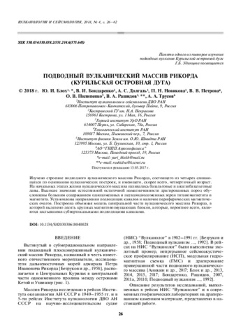
This paper reports a study of the Rikord volcanic massif. The massif consists of four volcanic edifices that coalesce in their bases, and is most likely Quaternary. The massif discharged basaltic and basaltic andesite lavas during its earlier life. The observed high natural remanent magnetization that was found in dredged rocks is due to high concentrations of single-domain and pseudo-single-domain grains of titanomagnetite and magnetite. We have identified the directions of the conduits and the presence of peripheral magma chambers. A 3D model has been developed for the central part of the Rikord volcanic massif; the model includes ten large disturbing magnetic blocks that are most likely cooled, nearly vertical, conduits.