Гришин С.Ю., Перепелкина П.А., Бурдуковский М.Л., Яковлева А.Н. Начало восстановления лесной растительности после воздействия пирокластической волны вулкана Шивелуч (Камчатка) 27 февраля 2005 г. // Вестник КРАУНЦ. Серия: Науки о Земле. 2017. Вып. 36. № 4. С. 28-38.
Annotation
In the spruce forest destroyed by a powerful pyroclastic surge, willow has been reestablishing on the surge deposits. Over a decade, the willow has formed a 6–8 m high canopy. The authors have specified the following factors that contributed to such a rapid reestablishing: a favourable moisture regime of the root zone caused by the deposition of the surge, the resources of the buried soil that feed the willows, and a certain protective role of dead trees. Prospects of further succession are being discussed; the authors have concluded that over about a 50-year-long period the willow will mostly fall out; by the end of the century the spruce will have partially restored its positions, but the stand will be mixed.
Кирюхин А.В., Федотов С.А., Кирюхин П.А., Черных Е.В. Магматические питающие системы Корякско-Авачинской группы вулканов по данным локальной сейсмичности и режима прилегающих термальных источников // Вулканология и сейсмология. 2017. № 5. С. 3-17.
Козлов Д.Н., Дегтерев А.В., Рыбин А.В., Коротеев И.Г., Климанцов И.М., Чаплыгин О.В., Чаплыгин И.В. Первые результаты батиметрической съемки вулканического озера Кольцевое (о. Онекотан, Северные Курильские острова) // Вестник КРАУНЦ. Серия: Науки о Земле. 2017. Вып. 33. № 1. С. 89-95.
Annotation
The paper provides preliminary results from the bathymetric studies of Koltsevoye volcanic lake (Onekotan Island, the Northern Kuriles). We describe the main morphological and morphometric parameters and represent a bathymetric scheme.
Кугаенко Ю.А., Павлов В.М., Иванова Е.И., Абубакиров И.Р., Салтыков В.А. Толудская вспышка сейсмичности и землетрясение 30.11.2012 г. (MС = 5.4, MW = 4.8), сопровождавшие начало Толбачинского извержения 2012-2013 гг. // Вулканология и сейсмология. 2017. № 6. С. 33-48. doi: DOI: 10.7868/S0203030617060049.
Annotation
This paper reports a study of the Tolud earthquake sequence; the sequence was a burst of shallow
seismicity between November 28 and December 7, 2012; it accompanied the initial phase in the Tolbachik
Fissure Eruption of 2012‒2013. The largest earthquake (the Tolud earthquake of November 30, 2012, to be
referred to as the Tolud Earthquake in what follows, with KS = 11.3, ML = 4.9, MС = 5.4, and MW = 4.8) is
one of the five larger seismic events that have been recorded at depths shallower than 10 km beneath the entire Klyuchevskoi Volcanic Cluster in 1961‒2015. It was found that the Tolud earthquake sequence was the foreshock–aftershock process of the Tolud Earthquake. This is one of the larger seismicity episodes ever to have
occurred in the volcanic areas of Kamchatka. Data of the Kamchatka seismic stations were used to compute
some parameters for the Tolud Earthquake and its largest (МL = 4.3) aftershock; the parameters include the
source parameters and mechanisms, and the moment magnitudes, since no information on these is available
at the world seismological data centers. The focal mechanisms for the Tolud Earthquake and for its aftershock are consistent with seismic ruptures at a tension fault in the rift zone. Instrumental data were used to estimate the intensity of shaking due to the Tolud Earthquake. We discuss the sequence of events that was a signature of the time-dependent seismic and volcanic activity that took place in the Tolbachik zone in late November 2012 and terminated in the Tolud burst of seismicity. Based on the current ideas of the tectonics and magma sources for the Tolbachik volcanic zone, we discuss possible causes of these earthquakes.
Кугаенко Ю.А., Салтыков В.А., Абкадыров И.Ф., Воропаев П.В. Временные сейсмологические наблюдения в районе трещинного Толбачинского извержения 2012-2013 гг. И их результаты // Вулканология и сейсмология. 2017. № 4. С. 67-82. doi: 10.7868/S0203030617040058.
Annotation
The seismicity that accompanied the Tolbachik Fissure Eruption was recorded by additional seismic stations that were installed in the southern Klyuchevskoi Volcanic Cluster area in January to October 2013. We used broadband (0.033–50 Hz) three-component digital Guralp CMG-6TD seismometers. This temporary network provided seismicity data at a lower energy level than can be done using the regional seismograph network of Kamchatka. The processing of the resulting digital records supplied data for compiling a catalog of over 700 ML=0–3.5 (КS=1.5–8.5) earthquakes, which is an order of magnitude greater than the number of events located by the regional network for the same period of time. The seismicity in the area of Ploskii Tolbachik Volcano was found to concentrate mostly in spatially isolated areas during the eruption. The main isolated clusters of earthquakes were identified both in the eruption area itself and along the periphery of Ploskii Tolbachik Volcano, in the area of the Zimina volcanic massif, and in the Tolud epicenter zone; the eruption zone was not dominant in the seismicity. The region of a shallow seismicity increase beneath Ploskii Tolbachik before the eruption was not found to exhibit any increased activity during the time the temporary seismograph network was operated, which means that a seismicity inversion took place at the beginning of the eruption. We discuss the question of what the earthquake-generating features are that we have identified.
Латышев А.В., Кушлевич Д.О., Пономарева В.В., Певзнер М.М. Вековые вариации геомагнитного поля последних 4000 лет, записанные в лавах и пирокластике Северной группы вулканов Камчатки: новые данные // Физика Земли. 2017. № 5. С. 1-10.
Annotation
Получены новые палеомагнитные определения по лавовым потокам и вулканическим пеплам Северной группы вулканов Камчатки, удовлетворяющие современным методическим и аппаратурным требованиям к проведению палеомагнитных исследований. В интервале последних 4000 лет исследовано 12 стратиграфических уровней, датированных тефрохронологическим методом. Полученные направления геомагнитного поля восполняют недостаток данных по вековым вариациям для северо-востока Азии и могут быть использованы при разработке глобальных моделей геомагнитного поля. Кроме того, показана перспективность использования вариаций геомагнитного поля для региональной корреляции вулканических событий.
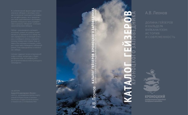
Леонов А.В. Каталог гейзеров Кроноцкого заповедника. Долина гейзеров и кальдера вулкана Узон: история и современность. М.: Изд-во ООО «Реарт». 2017. 384 с.
Annotation
В систематической форме представлено описание гейзеров и некоторых кипящих источников Кроноцкого
заповедника: как действующих, так и прекративших своё существование к настоящему времени. Большая их
часть сосредоточена в долине р. Гейзерной – всемирно известной Долине гейзеров.
Гейзер – разновидность кипящего источника; режим его работы может меняться со временем (т. е. гейзер
может «превратиться» в кипящий источник, и наоборот), потому и провести границу между ними можно лишь
условно. Все кипящие источники, у которых когда-либо наблюдался гейзерный режим, классифицированы
в каталоге как гейзеры.
Каталог содержит также исторический очерк и обзор литературы и будет интересен всем, кто интересуется достопримечательностями Кроноцкого заповедника.
Малик Н.А., Зеленский М.Е., Округин В.М. Температура и состав газа фумарол вулкана Авачинский (Камчатка) в 2013−2016 гг. // Вестник КРАУНЦ. Серия: Науки о Земле. 2017. Вып. 33. № 1. С. 21-33.
Annotation
The article presents data on Avachinsky Volcano fumaroles' temperature and gas composition obtained during the 2013-2016 observations and shows temperature dynamics over this period of the high-temperature Western fumarole and Eastern fumarolic field assigned to the fissure appeared in lava «plug» as a result of the weak explosive eruption in autumn 2001. Temperature of 818°С was registered in the Western fumarole to be the highest ever measured at Avachinsky Volcano. Gas composition of the monitored fumarole on Eastern field and its variation in time were studied. We compared the obtained data with the previous data on gas observations from Avachinsky Volcano and other active volcanoes in Kamchatka and the data on the average values from the volcanoes of the subduction zones.
Мельников Д.В., Крамарева Л.С., Маневич А.Г., Гирина О.А., Уваров И.А., Марченков В.В. Анализ временных рядов яркости термальных аномалий вулканов Камчатки по данным спутника Himawari-8 // Современные проблемы дистанционного зондирования Земли из космоса. Тезисы докладов. Пятнадцатая Всероссийская открытая конференция. 13-17 ноября 2017 г. М.: ИКИ РАН. 2017. С. 106
Мельников Д.В., Маневич А.Г., Гирина О.А. Алгоритм автоматического анализа спутниковых снимков MODIS для мониторинга активности вулканов Камчатки и Курильских островов // Материалы XX региональной научной конференции «Вулканизм и связанные с ним процессы», посвящённой Дню вулканолога, 30-31 марта 2017 г. Петропавловск-Камчатский: ИВиС ДВО РАН. 2017. С. 62-65.