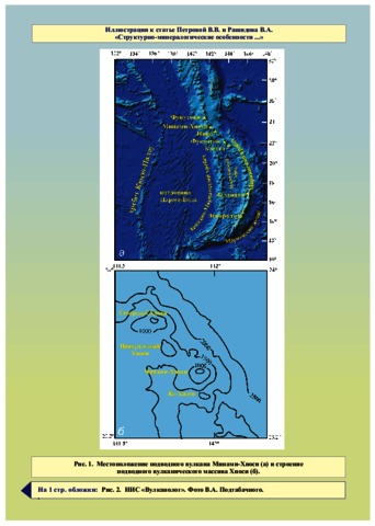
Петрова В.В., Рашидов В.А. Структурно-минералогические особенности и проблема генезиса пород подводного вулкана Минами-Хиоси (Марианская островная дуга) // Вестник КРАУНЦ. Серия: Науки о Земле. 2016. Вып. 32. № 4. С. 35-58.
Annotation
For the first time ever among the Russian papers, this article presents description of material composition of rocks from submarine Minami-Hiyoshi Volcano, which is a part the Hiyoshi Volcanic Complex located in the northern area of the Mariana Island Arc. The investigation provided new data on structure, chemical and mineral composition of rock composing it, as well as genesis of the Minami-Hiyoshi lavas. The investigation revealed genetic affinity of all studied rocks and showed that they originate from one basaltic magma, while structural and petrographic differences are caused by various processes of differentiation and dynamics of melt on its way to the surface.
Пономарев Г.П., Пузанков М.Ю. Распределения породообразующих элементов в системе расплав–шпинель–оливин с участием водного флюида по экспериментальным данным // Вестник КРАУНЦ. Серия: Науки о Земле. 2016. Вып. 32. № 4. С. 59-72.
Annotation
The authors revealed trends of inter-phase distributions of rock-forming elements in the system melt–spinel–olivine based on experimental data obtained under a wide range of conditions. 78 equations allow us to evaluate phases equilibrium in multisystem melt–spinel–olivine, and consequently estimate equilibrium values of temperature, pressure and content of a variety of elements and their ratios in a melt.
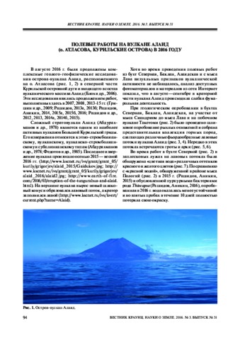
Рашидов В.А., Аникин Л.П. Полевые работы на вулкане Алаид (о. Атласова, Курильские острова) в 2016 году // Вестник КРАУНЦ. Серия: Науки о Земле. 2016. Вып. 31. № 3.
Рашидов В.А., Пилипенко О.В., Петрова В.В. Петромагнитные и петрографо-минералогические исследования горных пород, драгированных на подводных вулканах Охотоморского склона северной части Курильской островной дуги // Физика Земли. 2016. № 4. С. 84-106.
Романова И.М., Гирина О.А. Информация KVERT в сети Интернет // Материалы XVIII региональной научной конференции «Вулканизм и связанные с ним процессы», посвящённой Дню вулканолога, 30 марта - 1 апреля 2015 г. Петропавловск-Камчатский: ИВиС ДВО РАН. 2016. С. 92-96.
Романова И.М., Гирина О.А., Мельников Д.В., Маневич А.Г., Нуждаев А.А. База данных «Активность вулканов Камчатки и Северных Курил». 2016. Свидетельство о регистрации программы для ЭВМ № 2016620357. 17.3.2016.
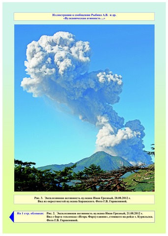
Рыбин А.В., Дегтерев А.В., Чибисова М.В., Гурьянов В.Б., Коротеев И.Г. Вулканическая активность на Курильских островах в 2012-2015 гг. // Вестник КРАУНЦ. Серия: Науки о Земле. 2016. Вып. 30. № 2. С. 77-87.
Annotation
The paper presents data that describe the Kuril Island Arc volcanic activity over the 2012-2015 period collected using satellite monitoring and visual observations, as well as the results of field studies at the active volcanoes. The authors analyzed eruptions of Ivan Grozny, Kudryavy (Iturup Island), Snow (Chirpoi Island), Chirinkotan (Chirinkotan Island), Sinarka (Shiashkotan Island), Chikurachki (Paramushir Island), and Alaid (Atlasov Island) volcanoes.
Савельева О.Л., Савельев Д.П. Происхождение аномалий иридия и других элементов платиновой группы на разных стратиграфических уровнях // Вестник КРАУНЦ. Серия: Науки о Земле. 2016. Вып. 32. № 4. С. 73-87.
Annotation
The article provides the analysis of the published data on anomalies of iridium and other platinum-group elements (PGE) at different Phanerozoic stratigraphical levels and gives evidences of heterogeneity of these anomalies and arguments of different authors about their relation with impact, volcanic, paleoclimatic and biotic events. Most of iridium anomalies coincide with large extinctions of sea organisms. The authors revealed in Cretaceous paleoceanic deposits of Eastern Kamchatka (Kamchatsky Mys peninsula) PGE anomalies at two levels corresponding to oceanic anoxic events OAE2 and MCE.
Салтыков В.А. Формализованная методика прогноза извержений вулкана Безымянный (Камчатка) на основе статистической оценки уровня сейсмичности // Геофизические исследования. 2016. Т. 17. № 3. С. 45-59. doi: 10.21455/gr2016.3-4.
Annotation
The paper proposes a formalized technique of probabilistic forecast by applying statistical estimation of seismicity level and a number of additional functions that characterize the predictive situation. The possibilities of this method are illustrated by the example of seismic activation before the eruptions of Bezymianny Volcano (Klyuchevskaya group, Kamchatka).
The initial data is the catalog of earthquakes of the Klyuchevskaya group of volcanoes during 1999-2014, compiled by the Kamchatka Branch of the Geophysical Survey, RAS. During this time there were 21 eruptions of Bezymianny Volcano. The precursor is defined as a threshold function associated with the current seismicity level and its characteristic form before the eruption.
The values of parameters characterizing the precursor are given including validity, reliability and efficiency, calculated by two methods. It is shown that the reliability of the precursor decreases with the increase in threshold values, and its validity increases.
The reliability of the method is 0.38–0.95, i.e., from 38 % to 95 % of eruptions had the precursor depending on the threshold level; and the validity is 0.3–0.6, i.e., from 30 % to 60 % of the identified precursors are realized also depending on the threshold level. Values of efficiency confirm the non-random nature of the precursor appearance.
The method includes determination of the probability of the forecast realization. The nomogram for probabilities depending on the duration of the forecast and the values of the prognostic parameter is designed.
Сорокин А.А., Королев С.П., Гирина О.А., Балашов И.В., Ефремов В.Ю., Романова И.М., Мальковский С.И. Интегрированная программная платформа для комплексного анализа распространения пепловых шлейфов при эксплозивных извержениях вулканов Камчатки // Современные проблемы дистанционного зондирования Земли из космоса. 2016. Т. 13. № 4. С. 9-19. https://doi.org/10.21046/2070-7401-2016-13-4-9-19.
Annotation
Analysis of the spread of ash clouds and plumes from volcano eruptions is a complex interdisciplinary task, hence implementation of the necessary methods and technologies exclusively on a single platform is extremely difficult. A more efficient approach is associated with the organization of interaction between already existing information systems and services developed on the basis of particular scientific competence and specialized data archives formed and built in the corresponding supporting software and hardware infrastructure. Based on this approach, a software platform was implemented integrating three information systems: Signal, VOKKIA and VolSatView. The platform provides computer modeling of ash clouds and plumes from the volcanoes of Kamchatka, and joint analysis of modeling calculation results with remote sensing data. The paper describes the platform, and the architecture of interaction of specialized applications and information systems, tools and technologies used for computer modeling, exchange of scientific data and working with them. The article includes examples of user interfaces for setting computing tasks and conduct joint analysis of modeling results using the data obtained by remote sensing of the Earth from space.