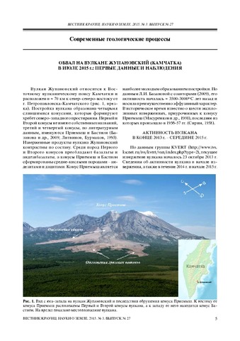
Горбач Н.В., Самойленко С.Б., Плечова А.А., Мельников Д.В. Обвал на вулкане Жупановский (Камчатка) в июле 2015 г.: первые данные и наблюдения // Вестник КРАУНЦ. Серия: Науки о Земле. 2015. Вып. 27. № 3. С. 5-11.
Гордеев Е.И., Гирина О.А., Лупян Е.А. , Кашницкий А.В., Уваров И.А., Ефремов В.Ю., Мельников Д.В., Маневич А.Г., Сорокин А.А., Верхотуров А.Л., Романова И.М., Крамарева Л.С., Королев С.П. Изучение продуктов извержений вулканов Камчатки с помощью гиперспектральных спутниковых данных в информационной системе VolSatView // Современные проблемы дистанционного зондирования Земли из космоса. 2015. Т. 12. № 1. С. 113-128.
Annotation
Annually in Kamchatka from three to eight volcanoes are in eruptions or in a state of unrest. Multidisciplinary study of each eruption encompassing the history and evaluation of geological effect with the detailed examination of volcanogenic products is needed to assess the dynamics of volcanic activity and hazard to population. The combined efforts of experts from IVS FEB RAS, IKI RAS, CC FEB RAS and FEC FSI RCSH “Planeta” led to the development of the information system called Monitoring of Activity of Kamchatkan Volcanoes (VolSatView, http://volcanoes.smislab.ru). The system allows working with various satellite data of mid to high resolution, meteorological and instrumental information from on-ground observation networks and to conduct combined analyses of diverse data. Currently, the VolSatView features an advanced instrumental base for the analyses of hyperspectral data that could be applied for the examination of volcanic activity. This paper illustrates application of the VolSatView in studying eruptive products of the Northern group of Kamchatka volcanoes (ex. pyroclastic and lava formations) based on hyperspectral satellite data. It is found that spectral reflectivity is indicative of pyroclastic rocks of andesitic composition, whereas spectral brightness is more informative in examination of fresh hot lava. Basaltic and andesitic lavas differ in spectral parameters, for example, in profile configurations of spectral brightness and their values.
Гришин С.Ю. Воронки взрывов у края лавового потока Толбачинского извержения (Камчатка, 2012-2013 гг.) // Вестник КРАУНЦ. Серия: Науки о Земле. 2015. Вып. 28. № 4. С. 72-79.
Annotation
Investigation of place of contact between the fresh lava flow from the 2012-2013 Tolbachik eruption and forest vegetation revealed an unusual phenomenon such as craters from explosions, partially destroyed old lava cover and soil-pyroclastic cover. Besides, traces of powerful scorching on the trunks of alder thickets adjacent to the craters were also found. Most likely, these craters have resulted from explosions that occurred due to the concentration of methane in the cracks and cavities in the old lava. The methan was caused by wood pyrolysis, buried by red-hot lava of 2012 eruption.
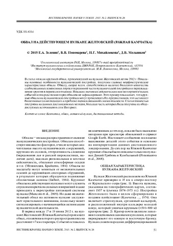
Зеленин Е.А., Пономарева В.В., Михайлюкова П.Г., Мельников Д.В. Обвал на действующем вулкане Желтовский (Южная Камчатка) // Вестник КРАУНЦ. Серия: Науки о Земле. 2015. Т. 26. № 2. С. 51-59.
Annotation
This paper describes a large landslide that occurred on Zheltovsky Volcano in summer 2012. The article describes main features of the volcanic edifice and considers parameters of the landslide. The landslide was likely caused by the altered rocks in the summit area as well as water infiltration during snow melting. No significant seismic or meteorological events had been registered immediately prior to the landslide. This example shows that large landslides at the volcanic edifices may occur without catastrophic precursors, which makes the hazard assessment more difficult. The paper is based exclusively on the remote sensing data most of which are available online from open sources.
Карданова О.Ф., Дубровская И.К., Муравьев Я.Д. Термоаномалии конуса Савича (вулкан Кихпиныч, Камчатка): результаты данных ИК-съемки и наземных наблюдений за 30 лет (1982-2012) // Вулканология и сейсмология. 2015. № 6. С. 24-33.
Коваленко Д.В., Петров В.А., Полуэктов В.В., Агеева О.А. Геодинамическая позиция мезозойских мантийных пород Стрельцовской кальдеры (Восточное Забайкалье), мантийные домены Центральной Азии и Китая // Вестник КРАУНЦ. Серия: Науки о Земле. 2015. Вып. 28. № 4. С. 24-39.
Annotation
New isotope-geochemical data for Jurassic-Cretaceous volcanic rocks from Streltsovkaya caldera allowed us to reveal the existence of several sources of the melts from which caldera igneous rocks were formed. Mantle melts (basalts and trachybasalts) were melted from mantle garnet lherzolites characterized by εNd(T) = -0.9 — 3.4, ISr(T) = 0.7056-0.707, Zr/Nb = 14-30, Nb/U = 4-8, Th/Ta = 5-15. The Streltsovskaya caldera magmatism began 160 million years ago. Apparently, it was genetically related to the onset of stretching in China and Mongolia. The mantle region from which were melted the late Jurassic-early Cretaceous melts in the Streltsov caldera, Bolshoj Khingan belt, Eastern China, southern Mongolia by isotope-geochemical characteristics can be combined into a single domain that differs from other mantle domains in China.
Кугаенко Ю.А., Воропаев П.В. Вариации статистической оценки уровня сейсмичности по шкале СОУС’09: вулкан Безымянный (Камчатка) // Вестник КРАУНЦ. Серия: Науки о Земле. 2015. Вып. 25. № 1. С. 31-40.
Annotation
We use SESL’09 technique for a unified estimation of seismicity level in a given space-time regions. The application of the distribution function of radiated seismic energy permits the formalization of qualitative description of seismicity. We present the results from statistical estimations of seismicity level before the 2000- 2012 Bezymianny Volcano eruptions. The state of seismicity was describes by the monogram, constructed according the SESL’09 technique. By processing the Klyuchevskoy volcano group seismic catalog, we estimated variations of seismicity and detected background level. Statistically significant variations of the seismicity level preceded the eruptions were detected and discussed.
Кугаенко Ю.А., Салтыков В.А., Горбатиков А.В., Степанова М.Ю. Развитие модели района Узон-Гейзерной вулкано-тектонической депрессии и вулкана Кихпиныч (Камчатка) по результатам совместного анализа данных микросейсмического зондирования и локальной геодинамической активности // Физика Земли. 2015. № 3. С. 89-101. doi: 10.7868/S0002333715030096.
Annotation
По данным микросейсмического зондирования построена глубинная модель среды под районом Узон-Гейзерной вулкано-тектонической депрессии и прилежащего к ней вулканического массива Кихпиныч (Камчатка) до глубины 30 км. Для этого была осуществлена регистрация естественного фонового микросейсмического поля переносными широкополосными сейсмометрами Guralp CMG-6TD в точках специально спланированной наблюдательной сети: в 60-ти точках вдоль трех профилей общей длиной около 28 км. Выявленные структурные неоднородности проинтерпретированы с учетом известных ранее результатов геологических, геолого-морфологических и петрологических исследований. Идентифицирована и пространственно локализована область малоглубинного закристаллизовавшегося магматического очага под депрессией. Выявлены области предположительной концентрации базальтовых расплавов, с которыми может быть связана наблюдающаяся в последние ~ 15 лет локальная геодинамическая активизация исследуемого района: периферический магматический очаг вулканического массива Кихпиныч на глубине 5-12 км, более глубокая (15-20 км) магматическая камера. Получено согласие геометрии обнаруженных глубинных структур с локальной микросейсмичностью и моделью современного магматического внедрения в верхние горизонты коры, разработанной по данным спутниковой интерферометрии.