Рычагов С.Н., Нуждаев А.А., Степанов И.И. Ртуть как индикатор cовременной рудообразующей газо-гидротермальной системы // Геохимия. 2014. № 2. С. 145-157. doi: 10.7868/S001675251312008X.
Аннотация
Обсуждаются новые данные о распределении ртути во вмещающих вулканогенно-осадочных и магматических горных породах, гидротермально-метасоматических породах и всех типах современных новообразований (гидротермальных глинах, аргиллизированных почвенно-пирокластических отложениях, кремнистых и лимонит-гематитовых плащах, донных осадках, солевых выпотах различного состава, и др.), характерных для зоны гипергенеза геотермальных месторождений. На примере Нижне-Кошелевского (пародоминирующего) и Паужетского (водного типа) геотермальных месторождений, термальных полей Кошелевского вулканического массива и Камбального вулканического хребта (Южная Камчатка) показано значение ртути как элемента-индикатора температуры, фазового состояния и динамики гидротерм, интенсивности процессов аргиллизации пород, относительного возраста (зрелости) геотермальных месторождений и термоаномалий.
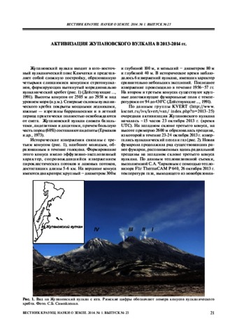
Самойленко С.Б., Мельников Д.В., Чирков С.А., Маневич Т.М. Активизация Жупановского вулкана в 2013-2014 гг. // Вестник КРАУНЦ. Серия: Науки о Земле. 2014. Вып. 23. № 1. С. 21-26.
Флеров Г.Б., Ананьев В.В., Пономарев Г.П. Минералогия пород вулканов Острый и Плоский Толбачиков, исторических извержений и первого этапа формирования зоны шлаковых конусов // Вулканизм и связанные с ним процессы. Материалы региональной конференции, посвященной Дню вулканолога, 27-28 марта 2014 г. Петропавловск-Камчатский: ИВиС ДВО РАН. 2014. С. 135-139.
Флеров Г.Б., Перепелов А.Б., Пузанков М.Ю., Колосков А.В., Философова Т.М., Щербаков Ю.Д. Пространственно-временные соотношения вулканических ассоциаций разной щелочности Белоголовского массива (Срединный хребет Камчатки). Часть 1. Геология, минералогия и петрология вулканических пород // Вулканология и сейсмология. 2014. Т. 2014. № 3. С. 3-23. doi:10.7868/S020303061403002X.
Аннотация
Предложена геолого-петрологическая модель формирования Белоголовского вулканического массива позднеплиоценового–раннеплейстоценового времени. Выделено две петрохимические серии пород разной щелочности: нормальной и умеренно-щелочной. Характер эволюции продуктов вулканизма и минералогический состав пород разной щелочности свидетельствуют о пространственной независимости и разной глубине очагов родительских магм их продуцирующих. Ведущим процессом, ответственным за образование расплавов, исходных для спектра пород внутри каждой серии, является кристаллизационная дифференциация. Эволюция щелочно-базальтовой магмы проходила ступенчато с образованием автономных дочерних расплавов состава: трахибазальты–трахиандезиты–трахиты–трахириолиты, комендиты, локализованных в разноглубинных промежуточных очагах.
Almeev Renat R., Kimura Jun-Ichi, Ariskin Alexei A., Ozerov Alexey Yu. Decoding crystal fractionation in calc-alkaline magmas from the Bezymianny Volcano (Kamchatka, Russia) using mineral and bulk rock compositions // Journal of Volcanology and Geothermal Research. 2013. Vol. 263. P. 141 - 171. doi: 10.1016/j.jvolgeores.2013.01.003.
Аннотация
We present a new dataset for whole-rock major, trace, isotopic, and phenocryst compositions indicating a genetic link between andesites of the Holocene eruptions of the Bezymianny stratovolcano (the Bezymianny stage), the andesitic to dacitic Late Pleistocene lava dome complex (the pre-Bezymianny stage), and the magnesian to high-alumina basalts of the adjacent Kliuchevskoi Volcano. We demonstrate that volcanic products from the Bezymianny stage of volcano evolution are most likely the products of magma mixing between silicic products of the earliest stages of magma fractionation and the less evolved basaltic andesite parental melts periodically injected into the magma reservoir. In contrast, the intermediate and silicic magmas of the pre-Bezymianny stage together with basalts from Kliuchevskoi much more closely resemble the liquid line of descent and may represent a unique prolonged and continuous calc-alkaline trend of magma evolution from high-magnesian basalt to dacite. As a result of the geothermobarometry, we recognize variable conditions of magma fractionation and magma storage beneath Bezymianny for different magma types during its evolution since the Late Pleistocene: (1) 1100–1150 °C, 500–640 MPa, 1–2.5 wt. H2O for parental basaltic andesite; (2) 1130–1050 °C, 700–600 MPa, 2.5–5 wt. H2O for two-pyroxene andesites; (3) 1040–990 °C, 560–470 MPa, 5–6.5 wt. H2O for orthopyroxene-bearing andesites; (4) 950–1000 °C, 450–150 MPa, 3.5–5.5 wt. H2O for hornblende-bearing andesites; and (5) 950–900 °C, 410–250 MPa, 6–7 wt. H2O for dacites. Repeated basalt injections and magma fractionation combined with internal mixing in the magma chamber are the main processes responsible for both the complex petrography and the geochemical trends observed in the lavas of Bezymianny Volcano.
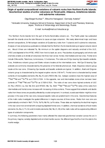
Bergal-Kuvikas Olga, Nakagawa Mitsuhiro, Avdeiko Gennady Origin of spatial compositional variations of volcanic rocks from Northern Kurile Islands: Geochemical studies of active volcanoes on Paramushir, Atlasova, Antsiferova islands and submarine volcanoes // International Association of Volcanology and Chemistry of the Earth's Interior (IAVCEI). 2013, Kagoshima. Japan.. 2013.
Churikova T.G., Ivanov B.V., Eichelberger J., Wörner G., Browne B., Izbekov P. Major and trace element zoning in plagioclase from Kizimen Volcano (Kamchatka): Insights into magma-chamber processes // Journal of Volcanology and Seismology. 2013. Vol. 7. № 2. P. 112-130. doi:10.1134/S0742046313020024.
Аннотация
The data on the geochemistry of the rocks of Kizimen Volcano and results of microprobe studies of major and trace elements in plagioclase grains from acid lavas and basalt inclusions are presented. The characteristics of the Kizimen Volcano are the following: (1) basalt inclusions are abundant in acid lavas; (2) banded, mixed lavas occur; (3) the distribution curves of rare earth elements of acidic lavas and basalt inclusions intersect; (4) Sr–Nd isotope systematics of the rocks and inclusions do not indicate mixture with crustal material; (5) plagioclase phenocrysts are of direct and reverse zonation; (6) olivine and hornblende, as well as acid and mafic plagioclases, coexist in the rocks. The studies revealed that the rocks are of a hybrid nature and originated in the course of repeated mixture of acid and mafic melts either with chemical and ther mal interaction of melts or exclusively thermal ones. Study of the major and trace element distribution in zonal minerals provides an informative tool for understanding the history of the generation and evolution of melts in a magma chamber
Churikova Tatiana G., Gordeychik Boris N., Ivanov Boris V., Wörner Gerhard Relationship between Kamen Volcano and the Klyuchevskaya group of volcanoes (Kamchatka) // Journal of Volcanology and Geothermal Research. 2013. Vol. 263. P. 3 - 21. doi: 10.1016/j.jvolgeores.2013.01.019.
Аннотация
Abstract Data on the geology, petrography, mineralogy, and geochemistry of rocks from Kamen Volcano (Central Kamchatka Depression) are presented and compared with rocks from the neighbouring active volcanoes. The rocks from Kamen and Ploskie Sopky volcanoes differ systematically in major elemental and mineral compositions and could not have been produced from the same primary melts. The compositional trends of Kamen stratovolcano lavas and dikes are clearly distinct from those of Klyuchevskoy lavas in all major and trace element diagrams as well as in mineral composition. However, lavas of the monogenetic cones on the southwestern slope of Kamen Volcano are similar to the moderately high-Mg basalts from Klyuchevskoy and may have been derived from the same primary melts. This means that the monogenetic cones of Kamen Volcano represent the feeding magma for Klyuchevskoy Volcano. Rocks from Kamen stratovolcano and Bezymianny form a common trend on all major element diagrams, indicating their genetic proximity. This suggests that Bezymianny Volcano inherited the feeding magma system of extinct Kamen Volcano. The observed geochemical diversity of rocks from the Klyuchevskaya group of volcanoes can be explained as the result of both gradual depletion over time of the mantle N-MORB-type source due to the intense previous magmatic events in this area, and the addition of distinct fluids to this mantle source.
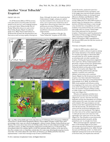
On 27 November 2012 at 1715 local time, a focused swarm of earthquakes was interpreted as the start of a new ongoing eruption on the south flank (Tolbachinsky Dol) of Plosky Tolbachik volcano in east central Kamchatka, Russia (Figure 1a) [Samoylenko et al., 2012]. Visual observations on 29 November showed ash shooting from two fractures as well as long, rapidly moving lava flows. Although the initial ash clouds reached 6 kilometers in height, subsequent ashfall has been limited to the area around the main vents, and no permanent settlements are in danger from advancing lava flows (the closest settlements are about 40 kilometers from the volcano). Including this eruption, six different volcanoes are presently active in Kamchatka.
Gavrilenko M., Carr M., Herzberg C., Ozerov A. Pyroxenite is a possible cause of enriched magmas in island arc settings: Gorely volcano (Kamchatka) // Abstract V31A-2666 presented at 2013 Fall Meeting, AGU, San Francisco, Calif., 9-13 Dec.. 2013.