Гирина О.А., Мельников Д.В., Маневич А.Г., Нуждаев А.А., Романова И.М., Лупян Е.А., Кашницкий А.В., Сорокин А.А., Крамарева Л.С. Эксплозивное извержение вулкана Безымянный 21 октября 2020 г. // Вулканизм и связанные с ним процессы. Материалы XXIV ежегодной научной конференции, посвящённой Дню вулканолога, 29-30 марта 2021 г. Петропавловск-Камчатский: ИВиС ДВО РАН. 2021. С. 29-31.
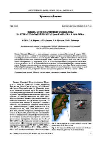
Гирина О.А., Озеров А.Ю., Цветков В.А., Демянчук Ю.В. Выжимание пластичных блоков лавы на вулкане Молодой Шивелуч (п-ов Камчатка) в 2020–2021 гг. // Вестник КРАУНЦ. Серия: Науки о Земле. 2021. Вып. 51. № 3. С. 77-83. https://doi.org/10.31431/1816-5524-2022-3-51-77-83.
Аннотация
Вулкан Молодой Шивелуч — один из самых активных вулканов Камчатки. С августа 1980 г. по настоящее время в кратере вулкана происходит рост экструзивного купола. Пластичные лавы в виде крупных лент отмечались на куполе уже в 1980–1981 гг., первый лавовый поток наблюдался после пароксизмального извержения 9 мая 2004 г. Очередной крупный блок лавы начал выжиматься с конца апреля — начала мая 2020 г., к 11 июня он поднимался над куполом на 50–80 м, к концу октября — до 120 м. 28 сентября было отмечено, что блок лавы приобрел гладкие поверхности. Порции лавы, выдавленные из недр вулкана в августе–сентябре, были пластичными. К 8 декабря блок разрушился. В феврале 2021 г. из разрушенного блока начал подниматься новый блок пластичной лавы, в марте его высота над куполом превысила 50–60 м, в июне — 200 м.
Гришин С.Ю., Белоусов А.Б, Белоусова М.Г., Ауэр A., Koзырев И.А. Эксплозивное извержение острова-вулкана Райкоке (Курилы) в 2019 г.: пирокластические отложения и их воздействие на рельеф и экосистемы // Вулканология и сейсмология. 2021. № 6. С. 30-42.
Аннотация
В июне 2019 г. на небольшом острове-вулкане Райкоке, расположенном в центральной части Курильской дуги, произошло короткое, но сильное эксплозивное извержение, кульминационная стадия которого продолжалась 3.5 ч, высота пеплового облака достигла 13 км. Анализ серии спутниковых изображений в сочетании с наземными исследованиями позволили охарактеризовать пирокластические отложения извержения и определить масштаб их воздействия на экосистемы острова. Установлено, что извержение имело фреатомагматический субплинианский–плинианский характер.
Калачева Е.Г. Экспедиционные исследования Курильских островов в 2021 г. // Вестник КРАУНЦ. Серия: Науки о Земле. 2021. Вып. 51. № 3. С. 101-110. doi: 10.31431/1816-5524-2022-3-51-101-110.
Аннотация
В данном сообщении приводится краткая характеристика экспедиционных работ на Курильских островах, выполненных сотрудниками Института вулканологии и сейсмологии ДВО РАН в рамках темы НИР и проектов РНФ и РФФИ летом 2021 г. С целью изучения химической эрозии вулканических островов и для оценки гидротермального выноса магматических летучих, проведены гидрологические и гидрохимические работы на реках, дренирующих склоны и термальных поля вулкана Баранского, вулканического массива Богдан Хмельницкий (о. Итуруп). Выполнены детальные гидрохимические исследования с отбором водных проб на разных глубинах и батиметрическая съемка оз. Кипящее, расположенного в кальдере вулкана Головнина (о. Кунашир). Продолжены работы по изучению диффузионного потока СO2 сквозь термальные поля и вулканические озера. В ходе продолжающихся режимных наблюдений на вулкане Эбеко (о. Парамушир) выполнена аэрофото- и инфракрасная съемка его прикратерной части. Впервые после начала извержения в 2016 г. с помощью квадрокоптера проведено опробование озера, расположенного в Среднем кратере вулкана. Для дальнейших аналитических исследований в ходе экспедиционных работ отобрано большое число водных и газовых проб, пополнена коллекция осадков.
Камчатские экспедиции вулканолога Бориса Пийпа (дневники 1931-1954 гг.) / Отв. ред. Белоусова М.Г., Белоусов А.Б. М.: Тов-во научных изданий КМК. 2021. 509 с.
Аннотация
В книге публикуются полевые дневники известного советского вулканолога,
основателя и первого директора Института вулканологии ДВО РАН на Камчатке,
члена-корреспондента Академии наук СССР Бориса Ивановича Пийпа (6.11.1906–10.03.1966), а также воспоминания о нем и его переписка. В книге описаны экспедиции 1931–1954 гг. на Ключевскую группу вулканов, на вулканы Авачинский, Шивелуч, Толбачик, в кальдеру Узон, на термальные ключи
Центральной и Северной Камчатки и на Курильские острова для изучения последствий цунами 1952 г.
Книга приурочена к 115-летию с даты рождения Б.И. Пийпа.
Нуждаев И.А., Озеров А.Ю., Нуждаев А.А., Мельников Д.В. Фумарола «Ледовая» вулкана Ичинский (Камчатка) в 2020 г. // Вестник КРАУНЦ. Серия: Науки о Земле. 2021. Вып. 52. № 4. С. 108-112. doi: 10.31431/1816-5524-2021-4-52-108-112.
Аннотация
Вулкан Ичинский — крупнейшее вулканическое сооружение Срединного хребта Камчатки. Проявление фумарольной деятельности на северном склоне вулкана известно с 1956 г. Спустя 64 года после открытия фумаролы «Ледовая» она была обследована с помощью квадрокоптера. Установлено, что фумарола находится на высоте 2725 м и представляет собой крупную воронку размером до 60 м, засыпанную в средней части снегом. В верхней части воронки имеется отверстие в ледовой толще в форме колодца диаметром 9.8 м, над кромкой которого до 5–10 м поднимаются парогазовые клубы. Стенки ледового колодца покрыты серо-желтым налетом возгонов. Авторы полагают, что вероятная температура парогазовой смеси фумаролы на выходе из пород вулкана существенно выше 100°С.
Федоров П.И., Цуканов Н.В., Гептнер А.Р., Петрова В.В. Вулканизм ранней стадии формирования острова Итуруп (Курильская островная дуга) // Вестник КРАУНЦ. Серия: Науки о Земле. 2021. Вып. 49. № 1. С. 87-98. doi: 10.31431/1816-5524-2021-1-49-87-98.
Аннотация
Представлены новые петрогеохимические данные по среднемиоцен-раннеплиоценовым вулканическим породам центральной части о. Итуруп. Показано, вулканизм среднемиоцен-раннеплиоценового возраста в центральной части о. Итуруп происходил в надсубдукционной обстановке. Распределение высокозарядных некогерентных элементов (HFSE) в базальтоидах свидетельствует об их формировании при частичном плавлении истощенной верхней мантии, тогда как обогащение пород крупноионными литофильными элементами (LILE) свидетельствует как о флюидной мантийной добавке, привнесенной в расплавы в ходе эволюции первичной магмы, так и об участии низкотемпературного надсубдукционного флюида. Установленные различия состава базальтоидов фронтальной и тыловой зон из-за ограниченного количества проанализированных образцов рассматриваются как предварительные. Так, базальтоиды тыловой зоны отличаются более высокими концентрациями Th, Pb, HFSE (Nb, Zr, Y, Hf), относительным обогащением LREE, выраженными негативными Zr- и Hf-аномалиями, и положительной Еu.
Фирстов П.П., Шакирова А.А., Максимов А.П., Черных Е.В. Активизация Авачинского вулкана в 2019 г. // Вулканология и сейсмология. 2021. № 3. С. 1-15. doi: 10.31857/S0203030621030032.
Аннотация
На основании изучения волновых форм и спектрального состава землетрясений, зарегистрированных в период активизации Авачинского вулкана в 2019 г., были выделены три общепринятых типа вулканических землетрясений (ВЗ): вулкано-тектонические, гибридные и длиннопериодные, а также четвертый – “особый” тип ВЗ, отличающийся особенностями волновых форм. Выделены 15 плоско-ориентированных кластеров и определены характеристики сейсмогенных площадок. Анализ сейсмических событий, зафиксированных осенью 2019 г. в Молодом конусе Авачинского вулкана, позволил предположить связь активизации с магматическими телами извержения 1991 г. в теле конуса и их взаимодействием с атмосферными осадками. Наиболее вероятной причиной световых вспышек над кратером, наблюдавшихся 8 декабря, представляется взаимодействие обогащенного водородом вулканического газа при контакте с кислородом воздуха.