Solubility of H2O- and CO2-bearing fluids in tholeiitic basalts at pressures up to 500 MPa (2010)
Shishkina T.A., Botcharnikov R.E., Holtz F., Almeev R.R., Portnyagin M.V. Solubility of H2O- and CO2-bearing fluids in tholeiitic basalts at pressures up to 500 MPa // Chemical Geology. 2010. Vol. 277. вДЦ 1вАУ2. P. 115 - 125. doi: 10.1016/j.chemgeo.2010.07.014.
–Р–љ–љ–Њ—В–∞—Ж–Є—П
The solubility of H2O- and CO2-bearing fluids in tholeiitic basalts has been investigated experimentally at temperature of 1250 ¬∞C and pressures of 50, 100, 200, 300, 400 and 500 MPa. The concentrations of dissolved H2O and CO2 have been determined using FTIR spectroscopy with an accurate calibration of the absorption coefficients for hydrogen- and carbon-bearing species using synthesized standards of the same tholeiitic composition. The absorption coefficients are 0.65 ¬± 0.08 and 0.69 ¬± 0.08 L/(mol cm) for molecular H2O and OH groups by Near-Infrared (NIR), respectively, and 68 ¬± 10 L/(mol cm) for bulk H2O by Mid-Infrared (MIR). The carbonate groups determined by MIR have an absorption coefficient of 317 ¬± 23 L/(mol cm) for the band at 1430 cmвИТ1.The solubility of H2O in the melt in equilibrium with pure H2O fluid increases from about 2.3 ¬± 0.12 wt.% at 50 MPa to about 8.8 ¬± 0.16 wt.% at 500 MPa, whereas the concentration of CO2 increases from about 175 ¬± 15 to 3318 ¬± 276 ppm in the melts which were equilibrated with the most CO2-rich fluids (with mole fraction of CO2 in the fluid, XflCO2, from 0.70 to 0.95). In melts coexisting with H2O- and CO2-bearing fluids, the concentrations of dissolved H2O and CO2 in basaltic melt show a non-linear dependence on both total pressure and mole fraction of volatiles in the equilibrium fluid, which is in agreement with previous studies. A comparison of new experimental data with existing numerical solubility models for mixed H2OвАУCO2 fluids shows that the models do not adequately predict the solubility of volatiles in basaltic liquids at pressures above 200 MPa, in particular for CO2, implying that the models need to be recalibrated.
The experimental dataset presented in this study enables a quantitative interpretation of volatile concentrations in glass inclusions to evaluate the magma storage conditions and degassing paths of natural island arc basaltic systems. The experimental database covers the entire range of volatile compositions reported in the literature for natural melt inclusions in olivine from low- to mid-K basalts indicating that most melt inclusions were trapped or equilibrated at intermediate to shallow levels in magmatic systems (< 12вАУ15 km).
Some Procedural Aspects of Comprehensive Prediction of Flank Eruptions of Klyuchevskoi Volcano (Kamchatka) (1989)
Shirokov V.A. Some Procedural Aspects of Comprehensive Prediction of Flank Eruptions of Klyuchevskoi Volcano (Kamchatka) // Volcanology and Seismology. 1989. Vol. 7. вДЦ 6. P. 921-942.
Some result of seismometric investigations at the Kamchatka Volcanological Station (1960)
Gorshkov G.S. Some result of seismometric investigations at the Kamchatka Volcanological Station // Bulletin Volcanologique. 1960. Vol. 23. Vol. 1. P. 121-128. doi: 10.1007/BF02596636.
Sources and Fluids in the Mantle Wedge below Kamchatka, Evidence from Across-arc Geochemical Variation (2001)
Churikova T., Dorendorf F., W√ґrner G. Sources and Fluids in the Mantle Wedge below Kamchatka, Evidence from Across-arc Geochemical Variation // Journal of Petrology. 2001. Vol. 42. вДЦ 8. P. 1567-1593. doi:10.1093/petrology/42.8.1567.
–Р–љ–љ–Њ—В–∞—Ж–Є—П
Major and trace element and SrвАУNdвАУPb isotopic variations in mafic volcanic rocks hve been studied in a 220 km transect across the Kamchatka arc from the Eastern Volcanic Front, over the Central Kamchatka Depression to the Sredinny Ridge in the back-arc. Thirteen volcanoes and lava fields, from 110 to 400 km above the subducted slab, were sampled. This allows us to characterize spatial variations and the relative amount and composition of the slab fluid involved in magma genesis. Typical Kamchatka arc basalts, normalized for fractionation to 6% MgO, display a strong increase in large ion lithophile, light rare earth and high field strength elements from the arc front to the back-arc. Ba/Zr and Ce/Pb ratios, however, are nearly constant across the arc, which suggests a similar fluid input for Ba and Pb. La/Yb and Nb/Zr increase from the arc front to the back-arc. Rocks from the Central Kamchatka Depression range in 87Sr/86Sr from 0¬Ј70334 to 0¬Ј70366, but have almost constant Nd isotopic compositions (143Nd/144Nd 0¬Ј51307вАУ0¬Ј51312). This correlates with the highest U/Th ratios in these rocks. Pb-isotopic ratios are mid-ocean ridge basalt (MORB)-like but decrease slightly from the volcanic front to the back-arc. The initial mantle source ranged from N-MORB-like in the volcanic front and Central Kamchatka Depression to more enriched in the back-arc. This enriched component is similar to an ocean-island basalt (OIB) source. Variations in (CaO)6¬Ј0вАУ(Na2O)6¬Ј0 show that degree of melting decreases from the arc front to the Central Kamchatka Depression and remains constant from there to the Sredinny Ridge. Calculated fluid compositions have a similar trace element pattern across the arc, although minor differences are implied. A model is presented that quantifies the various mantle components (variably depleted N-MORB-mantle and enriched OIB-mantle) and the fluid compositions added to this mantle wedge. The amount of fluid added ranges from 0¬Ј7 to 2¬Ј1%. The degree of melting changes from вИЉ20% at the arc front to <10% below the back-arc region. The rocks from volcanoes of the northern part of the Central Kamchatka DepressionвАФto the north of the transect considered in this studyвАФare significantly different in their trace element compositions compared with the other rocks of the transect and their source appears to have been enriched by a component derived from melting of the edge of the ruptured slab.
Space-Time and Dinamic Characteristics of Earthquakes Associated with the 1974 Eruption of Klyuchevskoi (1989)
Gorelchik V.I., Levina V.I. Space-Time and Dinamic Characteristics of Earthquakes Associated with the 1974 Eruption of Klyuchevskoi // Volcanology and Seismology. 1989. Vol. 7. вДЦ 6. P. 943-974.
Spaceborne and field-based observations of Bezymianny Volcano, Kamchatka from 2000-2008 (2008)
Carter A.J., Ramsey M.S., Girina O.A., Belousov A.B., Durant A., Skilling I., Wolfe A. Spaceborne and field-based observations of Bezymianny Volcano, Kamchatka from 2000-2008 // Abstracts. AGU Fall Meeting, 14-19 December. San-Francisco, USA: AGU. 2008. doi: V43A-2140.
Spaceborne observations of the 2000 Bezymianny, Kamchatka eruption: the integration of high-resolution ASTER data into near real-time monitoring using AVHRR (2004)
Ramsey Michael, Dehn Jonathan Spaceborne observations of the 2000 Bezymianny, Kamchatka eruption: the integration of high-resolution ASTER data into near real-time monitoring using AVHRR // Journal of Volcanology and Geothermal Research. 2004. Vol. 135. вДЦ 1-2. P. 127-146. doi:10.1016/j.jvolgeores.2003.12.014.
–Р–љ–љ–Њ—В–∞—Ж–Є—П
Since its launch in December 1999, the Advanced Spaceborne Thermal Emission and Reflection Radiometer (ASTER) instrument has been observing over 1300 of the world's volcanoes during the day and night and at different times of the year. At the onset of an eruption, the temporal frequency of these regularly scheduled observations can be increased to as little as 1вАУ3 days at higher latitudes. However, even this repeat time is not sufficient for near real-time monitoring, which is on the order of minutes to hours using poorer spatial resolution (>1 km/pixel) instruments. The eruption of Bezymianny Volcano (Kamchatkan Peninsula, Russia) in March 2000 was detected by the Alaska Volcano Observatory (AVO) and also initiated an increased observation frequency for ASTER. A complete framework of the eruptive cycle from April 2000 to January 2001 was established, with the Advanced Very High Resolution Radiometer (AVHRR) data used to monitor the large eruptions and produce the average yearly background state for the volcano. Twenty, nearly cloud-free ASTER scenes (2 days and 18 nights) show large thermal anomalies covering tens to hundreds of pixels and reveal both the actively erupting and restive (background) state of the volcano. ASTER short-wave infrared (SWIR) and thermal infrared (TIR) data were also used to validate the recovered kinetic temperatures from the larger AVHRR pixels, as well as map the volcanic products and monitor the thermal features on the summit dome and surrounding small pyroclastic flows. These anomalies increase to greater than 90 ¬∞C prior to a larger eruption sequence in October 2000. In addition, ASTER has the first multispectral spaceborne TIR capability, which allowed for the modeling of micrometer-scale surface roughness (vesicularity) on the active lava dome. Where coupled with ongoing operational monitoring programs like those at AVO, ASTER data become extremely useful in discrimination of small surface targets in addition to providing enhanced volcanic mapping capabilities.
Spatial Data Infrastructure for information support of volcanological investigations (2018)
Romanova I.M., Girina O.A. Spatial Data Infrastructure for information support of volcanological investigations // 10th Biennual workshop on Japan-Kamchatka-Alaska subduction processes (JKASP-2018). Petropavlovsk-Kamchatsky, Russia, August 20-26. // 10th Biennual workshop on Japan-Kamchatka-Alaska subduction processes (JKASP-2018). Petropavlovsk-Kamchatsky: IVS FEB RAS. 2018. P. 193-195.
Spatial and morphometric analyses of Anaun monogenetic volcanic field (Sredinny Range, Kamchatka) (2018)
Melnikov D.V., Volynets Anna Spatial and morphometric analyses of Anaun monogenetic volcanic field (Sredinny Range, Kamchatka) // 7th International Maar Conference, Olot, Catalonia, Spain. 2018. P. 61
–Р–љ–љ–Њ—В–∞—Ж–Є—П
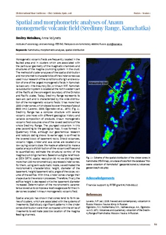
Monogenetic volcanic fields are frequently located in the faulted area and in clusters which are associated with the particular geometry of the magmatic chambers and structures of the magma plumbing system in the crust. The method of cluster analyses of the spatial distribution and morphometric characteristics of the cinder cones was used in our research of the conditions of origin and evolution of one of the largest monogenetic fields in Kamchat-ka back-arc-the Anaunsky Dol, or Anaun MVF. Kamchat-ka subduction system is located at the northwestern part of the Pacific at the convergent boundary of the Okhotsk and Pacific plates. Today, Sredinny Range represents its back-arc part and is characterized by the wide distribution of the monogenetic volcanic fields: it has more than 1000 cinder cones, which deposits cover the area of about 8500 km2 (Laverov, 2005; Ogorodov et al., 1972) (Fig. 1). Sredinny Range has a complex structure with several volcanic provinces with different geological history and variable composition of products. Anaun monogenetic volcanic field occupies one of the lowest sections of the whole Sredinny Range. The youngest volcanism in this area (according to the geological map, it was formed in Quaternary times, although our geochemical research and isotopic dating shows its earlier age) is confined to the lowered block of basement rocks. Shield volcanoes, volcanic ridges, cinder and lava cones are located on a low-laying volcanic dale. We made an attempt to make a spatial analysis of distribution of the volcanic edifices and to quantitatively estimate the structural control of the magma plumbing channels. Based on a digital relief model (DEM SRTM, spatial resolution 30 m) we distinguished more than 100 morphometrically expressed cinder cones. For them, using semi-automatic mode, we estimated the morphometric characteristics: height, diameter of the basement, height/basement ratio, angle of the slope, volume of the edifice. With time, cinder cones change their shape due to the erosion processes. Therefore, finally the edifice height is decreased while the basement diameter increased. Determination of the morphometric parameters allowed us to compose a relative age scale for the cinder cones located in Anaun monogenetic volcanic field. Spatial analysis has shown that cones tend to form series of clusters, which are associated with the systems of lineaments. Statistically significant patterns in the cinder cones distribution were then compared with the strike of lineaments to estimate possible location of the magma feeding channels.
Spatial compositional variations in Quaternary volcanic from the Northern Kuril Islands, Russia. (2011)
Bergal-Kuvikas Olga, Nakagawa Mitsuhiro, Avdeiko Gennady, Rashidov V.A. Spatial compositional variations in Quaternary volcanic from the Northern Kuril Islands, Russia. // 7th Biannual workshop on JKASP 2011: Mitigating risk through international volcano, earthquake and tsunami science.. 2011, Petropavlovsk-Kamchatsky. 2011.