Певзнер М.М., Пономарева В.В., Мелекесцев И.В. Черный Яр - реперный разрез голоценовых маркирующих пеплов северо-восточного побережья Камчатки // Вулканология и сейсмология. 1997. № 4. С. 3-18.
Annotation
Tephrochronological and radiocarbon investigations of soil-pyroclastic depositsalong the line Shiveluch Volcano - Chernyi Yar - Bering I. have detected and identified the ashes oflargest (for the past 6500 years) eruptions on Shiveluch Volcano in the southeastern sector of the ashabundance area, as well as the ashes of Bezymyannyi, Ksudach, Klyuchevskoi, Avacha and Khangarvolcanoes. A detailed radiocarbon dating of peat deposits in Chernyi Yar has not only improved the agedeterminations of the eruptions themselves but also helped in the determination of ash fall rate for thelower Kamchatka R. valley, namely, once in 191 years. Apart from the 1964 tephra, we suggest for useas regional geochronological markers the ash horizons of Shiveluch Volcano having the followingrounded radiocarbon dates: 265 (SH1), 965 (SH2), 1450, 2800, 3600 (SP), 4105 (SHDV), 4800, as well asthe ashes from Ksudach 1806 (KS1) and Avacha 5489 (AV2) volcanoes.
Перепелов А.Б., Пузанков М.Ю., Колосков А.В., Иванов А.В., Флеров Г.Б., Балуев Э.Ю., Философова Т.М. Происхождение щелочно-базальтовых магм с конвергенцией «внутриплитных» и островодужных» геохимических признаков (вулкан Большой Паялпан, Срединный хребет Камчатки) / Вулканизм и геодинамика.. 2006. Т. 3. С. 578-583.
Петров В.И. Петрографический облик игнимбритов и туфовых лав и их место среди горных пород, промежуточных между лавами и туфами // Труды Лаборатории вулканологии АН СССР. 1961. Вып. 20. С. 24-38.
Петров В.С., Цикунов А.Г., Пронин А.А. Стратиграфия отложений вулканогенно-кремнистой и терригенной формаций Валагинского хребта / Стратиграфия вулканогенных формаций Камчатки. Труды Института вулканологии СО АН СССР. М.: Наука. 1966. Вып. 23. С. 15-24.
Петров Л.Л., Кирсанов И.Т., Дубик Ю.М. Распределение Be и летучих (B,F) в продуктах последовательных извержений некоторых вулканов Камчатки и Курил // Геохимия магматических пород океана и зон сочленения океан-континент. Новосибирск: 1984. С. 162-170.
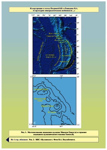
Петрова В.В., Рашидов В.А. Структурно-минералогические особенности и проблема генезиса пород подводного вулкана Минами-Хиоси (Марианская островная дуга) // Вестник КРАУНЦ. Серия: Науки о Земле. 2016. Вып. 32. № 4. С. 35-58.
Annotation
For the first time ever among the Russian papers, this article presents description of material composition of rocks from submarine Minami-Hiyoshi Volcano, which is a part the Hiyoshi Volcanic Complex located in the northern area of the Mariana Island Arc. The investigation provided new data on structure, chemical and mineral composition of rock composing it, as well as genesis of the Minami-Hiyoshi lavas. The investigation revealed genetic affinity of all studied rocks and showed that they originate from one basaltic magma, while structural and petrographic differences are caused by various processes of differentiation and dynamics of melt on its way to the surface.
Петрографический кодекс России. Магматические, метаморфические, метасоматические, импактные образования / Отв. ред. Шарпенок Л. П. СПб: Изд-во ВСЕГЕИ. 2009. 200 с.
Annotation
Petrographic Code of Russia is a set of fundamental rules and recommendations approving and confirming the unified and standardized petrographic terminology and nomenclature of endogenic and coptogenic formations, as well as the taxonomy of petrographic units. The unified notional base, which forms the basis of the Petrographic Code, is used during compilation of the State Geological Maps at different scales, serial legends to them, during forecast-prospecting works, thematic investigations, as well as during map compilation in the framework of international projects.
The Code of the second and third editions has a new structure as compared to the first one, new appendices are prepared. Taking into account new requirements of the geological practice, new sections on sedimentary-volcanogenic formations, migmatites etc. are added. Sections related to metamorphic and metasomatic formations are reworked; distinguishing of fluid-explosive rocks bearing different mineral types into an individual genetic type is substantiated. The content of most of previous provisions is changed; many articles are reworked or abbreviated, new ones are included. Recommendations of the Commission on Systematics in Petrology of the International Union of Geological Sciences are taken into account during development of the Code.
Петухов С.И., Анохин В.М., Мельников М.Е. Особенности геодинамических обстановок в районе Северо-Западного звена Магеллановых гор (Тихий океан) // Вестник КРАУНЦ. Серия: Науки о Земле. 2012. Вып. 20. № 2. С. 78-88.
Annotation
A lineament analysis of the relief was made using a detailed bathymetry map of the region drawn according to the results of multi-beam echo-sounding. The authors separated linear objects of the relief, measured their course azimuths, plotted the rose diagram of the lineament directivities of the region, and built the models of the surface and subsurface deformation field of the region at separating the blocks of dominant stress and strain. The blocks travel along the lines of alternation of stress sign (block borders). The directivities
of the block borders were compared with the lineaments directivities resulting in conclusion that they both have spatial and generic relations. The systems of linear forms directivities of the relief and the borders of surface and subsurface blocks partially correspond to the four main systems of the global disjunctive network (planetary fracturing), which suggests a considerable influence of the latter on the structural plan of the region.Redistribution of stresses is associated with the modern geological processes leading to the formation of new
configurations of seabed relief and partial destruction of the old surfaces of guyots.